
Plate boundaries of the Middle East

Detailed Description
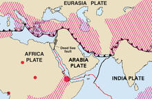
Generalized plate boundaries from This Dynamic Planet (USGS, 2006). Red lines are spreading boundaries, where new crust is generated as plates move away from one another; black lines are transform faults where plates slide past one another. Black lines with sawteeth are convergent boundaries, where one plate dives beneath another in direction of sawteeth. Hatched red lines are broad belts of deformation. Red dots are hotspots, where material from the Earth’s mantle wells up into the crust.
Sources/Usage
Public Domain.
Geologic Investigations Map I-2800: This Dynamic Planet
This Dynamic Planet: World Map of Volcanoes, Earthquakes, Impact Craters, and Plate Tectonics, Third Edition (Published 2006)