
Point misclassification lidar error
By NGP Standards and Specifications
2021 (approx.)

Detailed Description
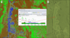
Lidar error dictionary figure 28. Elevation profile (B, along yellow double line shown in classified point cloud, A) shows ground points that have been misclassified as water (blue points) and inappropriately hydroflattened as seen in the digital elevation model (C) showing breakline (yellow line).
Sources/Usage
Public Domain.