
Potential Marine Benthic Habitats of Monterey Canyon and Vicinity

Detailed Description
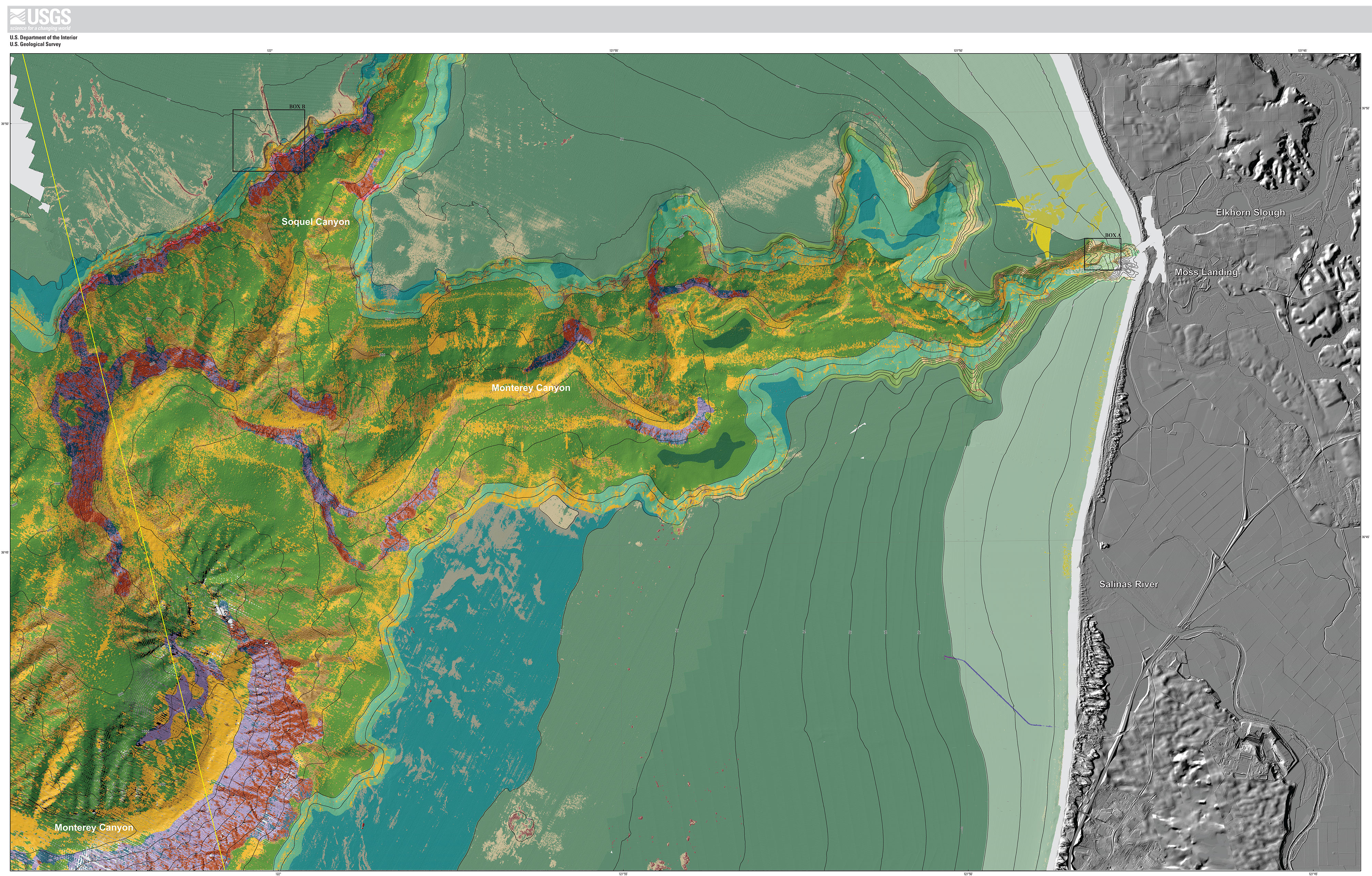
The map on sheet 7 shows “potential” marine benthic habitats in the Monterey Canyon and Vicinity map area, representing a substrate type, geomorphology, seafloor process, or any other attribute that may provide a habitat for a specific species or assemblage of organisms. This map, which is based largely on seafloor geology, also integrates information displayed on several other thematic maps of the Monterey Canyon and Vicinity map area. High-resolution sonar bathymetry data, converted to depth grids (seafloor DEMs), are essential to development of the potential marine benthic habitat map, as is shaded-relief imagery, which allows visualization of seafloor terrain and provides a foundation for interpretation of submarine landforms.
Backscatter maps also are essential for developing potential benthic habitat maps. High backscatter is further indication of “hard” bottom, consistent with interpretation as rock or coarse sediment. Low backscatter, indicative of a “soft” bottom, generally indicates a fine sediment environment. Habitat interpretations also are informed by actual seafloor observations from ground-truth surveying, by seafloor-character maps that are based on video-supervised maximum-likelihood classification, and by seafloor-geology maps. The habitat interpretations are further informed by the usSEABED bottom-sampling compilation of Reid and others (2006).
Broad, generally smooth areas of seafloor that lack sharp and angular edge characteristics are mapped as “sediment;” these areas may be further defined by various sedimentary features (for example, erosional scours and depressions) and (or) depositional features (for example, dunes, mounds, or sand waves). In contrast, many areas of seafloor bedrock exposures are identified by their common sharp edges and high relative relief; these may be contiguous outcrops, isolated parts of outcrop protruding through sediment cover (pinnacles or knobs), or isolated boulders. In many locations, areas within or around a rocky feature appear to be covered by a thin veneer of sediment; these areas are identified on the habitat map as “mixed” induration (that is, containing both rock and sediment). The combination of remotely observed data (for example, high-resolution bathymetry and backscatter, seismic-reflection profiles) and directly observed data (for example, camera transects, sediment samples) translates to higher confidence in the ability to interpret broad areas of the seafloor.
To avoid any possible misunderstanding of the term “habitat,” the term “potential habitat” (as defined by Greene and others, 2005) is used herein to describe a set of distinct seafloor conditions that in the future may qualify as an “actual habitat.” Once habitat associations of a species are determined, they can be used to create maps that depict actual habitats, which then need to be confirmed by in situ observations, video, and (or) photographic documentation.
Learn more!
Dartnell, P., Maier, K.L., Erdey, M.D., Dieter, B.E., Golden, N.E., Johnson, S.Y., Hartwell, S.R., Cochrane, G.R., Ritchie, A.C., Finlayson, D.P., Kvitek, R.G., Sliter, R.W., Greene, H.G., Davenport, C.W., Endris, C.A., and Krigsman, L.M. (P. Dartnell and S.A. Cochran, eds.), 2016, California State Waters Map Series—Monterey Canyon and Vicinity, California: U.S. Geological Survey Open-File Report 2016–1072, 48 p., 10 sheets, scale 1:24,000, https://doi.org/10.3133/ofr20161072.
Sources/Usage
Public Domain.