
San Francisco Bay and Delta DEM

Detailed Description
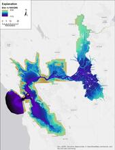
High-resolution (10-meter per pixel) digital elevation model (DEM) of the Sacramento-San Joaquin Delta, using both bathymetry and topography data relative to current modern datum of North American Vertical Datum of 1988 (NAVD88). This DEM is the result of collaborative efforts of the U.S. Geological Survey (USGS) and the California Department of Water Resources (DWR).
Sources/Usage
Public Domain.
San Francisco Bay-Delta bathymetric/topographic digital elevation model (DEM)
Fregoso, T.A., Wang, R-F, Alteljevich, E., and Jaffe, B.E., 2017, San Francisco Bay-Delta bathymetric/topographic digital elevation model (DEM): U.S. Geological Survey data release, https://doi.org/10.5066/F7GH9G27.