
San Joaquin Valley Land Subsidence Monitoring Network (2000s - 2010s)
By Land Subsidence in California
2015 (approx.)

Detailed Description
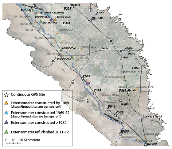
History of the San Joaquin Valley Land Subsidence Monitoring Network
California has experienced three droughts thus far in the 21st century (2001-2002, 2007-2009, and 2012-2016), bringing renewed subsidence to the San Joaquin Valley and the revitalization of the Monitoring Network. Four extensometers were refurbished in 2011-2012, which involved new reference tables and instrumentation, and the construction of new shelters. These were added to the six extensometers that were operating at five sites. Spirit-leveling and campaign GPS networks were generally maintained on major water-conveyance canals and highways only, and 13 Continuous GPS sites (maintained by various agencies/groups) are in operation on the Valley floor.
Sources/Usage
Public Domain.
Related

Land Subsidence in the San Joaquin Valley
The San Joaquin Valley is one of the most productive agricultural regions in the nation. Beginning around the 1920's, farmers relied upon groundwater for water supply. Over time, overpumping caused groundwater-level declines and associated aquifer-system compaction and land subsidence that resulted in permanent aquifer-system storage loss.
Related
Land Subsidence in the San Joaquin Valley
The San Joaquin Valley is one of the most productive agricultural regions in the nation. Beginning around the 1920's, farmers relied upon groundwater for water supply. Over time, overpumping caused groundwater-level declines and associated aquifer-system compaction and land subsidence that resulted in permanent aquifer-system storage loss.