
Scanning surface rupture from Searles Valley earthquake

Detailed Description
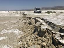
USGS Earthquake Science Center Mobile Laser Scanning truck operated by Ben Brooks and Todd Ericksen scanning the surface rupture near the zone of maximum surface displacement of the M7.1 Searles Valley earthquake.
Sources/Usage
Public Domain.