
Screenshot of FDST flood damage estimate reports

Detailed Description
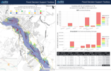
Screenshot of FDST flood damage estimate reports
Updated flood damage estimate reports - with maps, graphs, and data - can be viewed, downloaded, and printed from the tool. These reports are related to selected inundation levels at specific sites across the state where inundation map libraries are currently available. To access flood damage estimate reports, first click a river station of interest on the Texas map. This will open the flood map library and the current conditions for that station. Turn on the “buildings” slider and then select a “Simulated River Stage” level from the Flood Map Library.
Sources/Usage
Public Domain.