
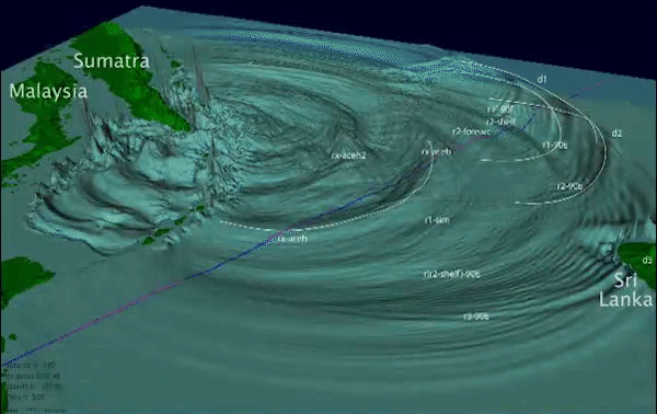
Simulated view of the tsunami wavefield looking southeast
Detailed Description
This animation shows the evolution of tsunami waves caused by the December 26, 2004 earthquake. A detailed depiction of the different tsunami waves (phases) is shown in this animation. Phases d1, d2, and d3 are direct arrivals from source regions located from south to north along the Sumatra-Andaman subduction zone. The phases beginning with the letter r originate as reflections from various coastlines and bathymetric features. The animation ends two hours after the earthquake when the Jason-1 satellite passes through the Bay of Bengal. The Jason-1 trackline is colored pink where the model amplitudes are positive and colored blue where they are negative.
Sources/Usage
Public Domain.
Related

Tsunami Generation from the 2004 M=9.1 Sumatra-Andaman Earthquake
The December 26, 2004 magnitude (M) 9.1 Sumatra-Andaman earthquake occurred along a tectonic subduction zone in which the India Plate, an oceanic plate, is being subducted beneath the Burma micro-plate, part of the larger Sunda plate. The boundary between the downgoing and overriding plates of the subduction zone is marked by the Sunda Trench above. Here we provide a brief overview of the tectonic...
Related
Tsunami Generation from the 2004 M=9.1 Sumatra-Andaman Earthquake
The December 26, 2004 magnitude (M) 9.1 Sumatra-Andaman earthquake occurred along a tectonic subduction zone in which the India Plate, an oceanic plate, is being subducted beneath the Burma micro-plate, part of the larger Sunda plate. The boundary between the downgoing and overriding plates of the subduction zone is marked by the Sunda Trench above. Here we provide a brief overview of the tectonic...