
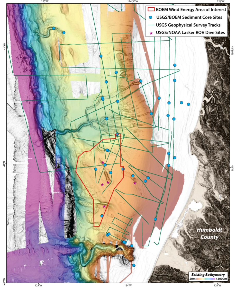
Southern Cascadia bathymetry
By Pacific Coastal and Marine Science Center
2018 (approx.)

Detailed Description
High-resolution bathymetric data of southern Cascadia showing the BOEM Northern California Call Area for offshore wind energy, USGS/BOEM sediment coring sites, USGS geophysical survey tracks, and NOAA Lasker ROV dive sites.
Sources/Usage
Public Domain.
Related

Cascadia Subduction Zone Marine Geohazards
Societal Issue: Uncertainty related to rupture extent, slip distribution, and recurrence of past subduction megathrust earthquakes in the Pacific Northwest (northern CA, OR, WA, and southern BC) leads to ambiguity in earthquake and tsunami hazard assessments and hinders our ability to prepare for future events.
By
Natural Hazards Mission Area, Coastal and Marine Hazards and Resources Program, Pacific Coastal and Marine Science Center, Santa Cruz Core Scanning Laboratory, Santa Cruz Core Laboratories, Santa Cruz Core Splitting Laboratory, Deep Sea Exploration, Mapping and Characterization, Subduction Zone Science

EXPRESS: Expanding Pacific Research and Exploration of Submerged Systems
EXPRESS is a multi-year, multi-institution cooperative research campaign in deep sea areas of California, Oregon, and Washington, including the continental shelf and slope. EXPRESS data and information are intended to guide wise use of living marine resources and habitats, inform ocean energy and mineral resource decisions, and improve offshore hazard assessments.
Related
Cascadia Subduction Zone Marine Geohazards
Societal Issue: Uncertainty related to rupture extent, slip distribution, and recurrence of past subduction megathrust earthquakes in the Pacific Northwest (northern CA, OR, WA, and southern BC) leads to ambiguity in earthquake and tsunami hazard assessments and hinders our ability to prepare for future events.
By
Natural Hazards Mission Area, Coastal and Marine Hazards and Resources Program, Pacific Coastal and Marine Science Center, Santa Cruz Core Scanning Laboratory, Santa Cruz Core Laboratories, Santa Cruz Core Splitting Laboratory, Deep Sea Exploration, Mapping and Characterization, Subduction Zone Science
EXPRESS: Expanding Pacific Research and Exploration of Submerged Systems
EXPRESS is a multi-year, multi-institution cooperative research campaign in deep sea areas of California, Oregon, and Washington, including the continental shelf and slope. EXPRESS data and information are intended to guide wise use of living marine resources and habitats, inform ocean energy and mineral resource decisions, and improve offshore hazard assessments.