
Uranium in Private Wells in Connecticut

Detailed Description
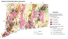
The colors on this map identify the estimated percentage of private wells in Connecticut with water containing uranium concentrations greater than 30 micrograms per liter, the U.S. Environmental Protection Agency’s maximum contaminant level for uranium in drinking water supplies. These percentages were determined based on an analysis of water samples from more than 2,000 private wells in the state as well as underlying geology, with bedrock types indicative uranium concentrations in groundwater. The green symbols identify uranium concentrations in water from sampled wells. White areas on the map, representing 2.3% of the state, indicate geologic units from which no uranium samples are available. Well locations are approximate.
Sources/Usage
Public Domain.