
USGS 21st Century Science - WILDLAND FIRE (landscape)
Detailed Description
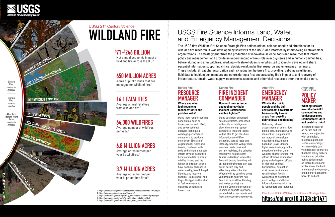
\$71-\$246 BILLION
Net annual economic impact of wildland fire across the U.S.1
650 MILLION
Acres of public lands that are managed for wildland fire.2
16.1 FATALITIES
Average annual fatalities from wildland fire.3
64,000 WILDFIRES
Average number of wildfires per year.4
6.8 MILLION
Average acres burned per year by wildfires.4
3.7 MILLION
Average acres burned per year in prescribed fires.5
USGS Fire Science Informs Land, Water, and Emergency Management Decisions
The USGS first Wildland Fire Science Strategic Plan defines critical science needs and directions for its wildland fire research. It was developed by scientists at the USGS and informed by interviewing 40 stakeholder organizations. The strategy prioritizes the production of innovative science, tools and resources that inform policy and management and provide an understanding of fire’s role in ecosystems and in human communities, before, during and after wildfires. Working with stakeholders is emphasized to identify, develop and share essential information supporting critical decision-making by fire, resource and emergency managers. These include: threat characterization and risk reduction before a fire; providing real-time satellite and field data to incident commanders and others during a fire; and assessing fire’s impact to and recovery of infrastructure, terrain, water supply, ecosystems, species and other vital resources after the smoke clears.
Before Fire
RESOURCE MANAGERDuring Fire
FIRE INCIDENT COMMANDERAfter Fire
EMERGENCY MANAGERAfter and Before Fire
POLICY MAKERWhere and what fuel treatments reduce wildfire and post-fire risks?
Using new remote-sensing capabilities, such as hyperspectral and LiDAR, and advanced data analysis techniques with high-performance computers, to produce the current 3D state of vegetation (or fuels) and terrain, combined with soils and climate data can inform physics-based fire behavior models to predict wildfire hazard and the follow-on threat of debris flow, flooding, changes in water quality, harmful algal blooms, and invasive species. Products will help target the type and location of fuel treatments to maximize benefits and lower risks.How will new science and technology help Incident Commanders and fire fighters?
Using data from advanced satellite systems, processed with artificial intelligence algorithms on high speed computers, Incident Teams will be able to get real-time information on wildfire detection, spread rates and intensity. Coupled with precise weather predictions and current fuel data, fire behavior models will help Incident Teams understand where the fires will be and how they will spread so firefighters can stay out of harm’s way and effectively attack the fires. When the fires burn into areas vulnerable to post-fire risk (such as debris flow, flooding, and water quality), the Incident Commander can call in science experts to provide detailed risk assessments and input on response alternatives.What is the risk to people and the built environment downstream from recently burned areas from post-fire debris flows and flooding?
Delivering refined assessments of debris-flow timing, size, inundation, and momentum using updated surface/soil mineralogy, new debris-flow models based on LiDAR-derived high-resolution topography, severity of the burn, and weather characteristics, will inform effective evacuation plans and mitigation efforts in high-risk settings. Furthermore, evaluation of airborne particulates resulting from fires in wildlands and developed areas will give additional information on health risks to responders and residents.What options are available to make communities and landscapes more resilient to wildfire and post-fire risks?
Integrated research on hazard and risk trends, in conjunction with ecological, meteorological, and surface mineralogy/ terrain models can yield forecast scenarios that help policy makers identify and prioritize policy options such as fuel reduction and protection of the built and natural environment, and plan for cascading hazards and risk.
Check out USGS Wildland Fire Science Strategic Plan
https://pubs.er.usgs.gov/publication/cir1471
Sources:
- https://nvlpubs.nist.gov/nistpubs/SpecialPublications/NIST.SP.1215.pdf
- https://viewer.nationalmap.gov/datasets/
- https://www.nifc.gov/safety/safety_documents/Fatalities-by-Year.pdf
- https://www.nifc.gov/fireInfo/fireInfo_stats_totalFires.html
- https://www.nifc.gov/fireInfo/fireInfo_stats_prescribed.html
Sources/Usage
Public Domain.