
USGS Collects Sediments Samples at Pascagoula Beach

Detailed Description
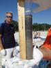
U.S. Geological Survey (USGS) scientists collected environmental data and samples at beach, barrier island, and wetland sites in response to the 2010 Deepwater Horizon oil spill in the Gulf of Mexico. The USGS Florida, Alabama, Mississippi, Louisiana, and Texas Science Centers collaborated to collect samples of water and sediments for analysis of inorganic and organic constituents, benthic invertebrates, and oil and microorganism fingerprints before and after petroleum-associated product arrived on shore.
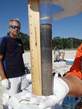
Sediment cores like the one in this photo allow scientists to see and analyze layers of sediment along the Gulf of Mexico shoreline. This core was collected in the swash zone at Pascagoula Beach, Pascagoula, MS, by the USGS Mississippi Water Science Center. This core intersected the water table; the blackened areas may indicate oil-impacted zones. USGS analyses of the sediment will be used to identify chemical and biological changes that may have been caused by the arrival of crude oil product from the failure of the Deepwater Horizon well. (The swash zone is the zone that is alternately covered and exposed by waves.)
You can view a map of related USGS sampling locations or access the data for sampling site MS-45.
Sources/Usage
Public Domain.