
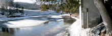
USGS gage 01135300, Sleepers River near St. Johnsbury

Detailed Description
The W-5 weir, USGS gage 01135300, Sleepers River near St. Johnsbury, at the Sleepers River Research Watershed, Danville, Vermont, looking upstream from the weir during an early snowmelt pulse.
Sources/Usage
Courtesy: Stephen Sebestyen
Related
Hydrologic Interpretive Branch
The Hydrologic Interpretive Branch collaborates with stakeholders to design, execute, and publish scientific studies that address issues associated with water resources at local, regional, and national scales. This branch has three sections that focus on watershed and urban hydrology, integrated modeling of hydrologic systems, and the development of new statistical and geospatial tools.

Sleepers River Research Watershed
The Sleepers River Research Watershed in Danville, Vermont has been the site of active hydrologic research since 1959, when the Agricultural Research Service (ARS) of the U.S. Department of Agriculture (USDA) established a research program in the watershed. The Sleepers River site is now operated by the USGS, in cooperation with several other Federal agencies and universities.
Related
Hydrologic Interpretive Branch
The Hydrologic Interpretive Branch collaborates with stakeholders to design, execute, and publish scientific studies that address issues associated with water resources at local, regional, and national scales. This branch has three sections that focus on watershed and urban hydrology, integrated modeling of hydrologic systems, and the development of new statistical and geospatial tools.
Sleepers River Research Watershed
The Sleepers River Research Watershed in Danville, Vermont has been the site of active hydrologic research since 1959, when the Agricultural Research Service (ARS) of the U.S. Department of Agriculture (USDA) established a research program in the watershed. The Sleepers River site is now operated by the USGS, in cooperation with several other Federal agencies and universities.