
Using drones to study groundwater

Detailed Description
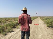
Did you know that plants can sometimes help us understand what is happening underground? Studying plants in an area can provide information about soil conditions, water availability, and water quality. In this photo, USGS Oregon Water Science Center hydrologist Brandon Overstreet is using a small unoccupied aircraft system – sUAS or "drone" – to collect information about vegetation on Malheur National Wildlife Refuge in Oregon in August 2018. The data will be used to improve our understanding of water resources in the Harney Basin, including groundwater availability.
The project is part of a demonstration and evaluation effort by the USGS Hydrogeophysics Branch in collaboration with USGS Water Science Centers to evaluate the integration of sUAS into USGS hydrogeophysical studies.
Sources/Usage
Public Domain.