In scattered places in the United States, carbonate rocks are interbedded with almost equal amounts of water-yielding sandstone. In most places where these two rock types are interbedded, the carbonate rocks yield much more water than the sandstone.

In scattered places in the United States, carbonate rocks are interbedded with almost equal amounts of water-yielding sandstone. In most places where these two rock types are interbedded, the carbonate rocks yield much more water than the sandstone.
Most carbonate rocks originate as sedimentary deposits in marine environments. Compaction, cementation, and dolomitization processes might act on the deposits as they lithify and greatly change their porosity and permeability. However, the principal postdepositional change in carbonate rocks is the dissolution of part of the rock by circulating, slightly acidic groundwater. Solution openings in carbonate rocks range from small tubes and widened joints to caverns that may be tens of meters wide and hundreds to thousands of meters long. Where they are saturated, carbonate rocks with well-connected networks of solution openings yield large amounts of water to wells that penetrate the openings, although the undissolved rock between the large openings may be almost impermeable.
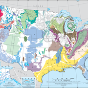
This map of sandstone and carbonate-rock aquifers in the United States shows the shallowest principal aquifer. In some places, other, sometimes more productive, aquifers underlie those mapped. Only small areas of some aquifers may be shown on the map because they are covered in many places by other aquifers closer to the land surface. In other places, local aquifers, such as those along stream valleys, might overlie the aquifers mapped. Local aquifers are not shown because of the scale of the map. Some aquifers in sedimentary rocks are overlain by confining units, and the aquifers extend into the subsurface beyond the areas shown on the map.

Sandstone and carbonate-rock aquifers include:
Edwards-Trinity aquifer system (Texas and Oklahoma)

- Oklahoma and Texas (Chapter E)
- Arkansas, Louisiana, and Mississippi (Chapter F)
Valley and Ridge aquifers (eastern U.S.)

- Delaware, Maryland, New Jersy, North Carolina, Pennsylvania, Virginia (Chapter L)
- Alabama, Florida, Georgia, and South Carolina (Chapter G)
Mississippian aquifers (central and eastern U.S.)

- Iowa, Michigan, Minnesota, and Wisconsin (Chapter J)
- Illinois, Indiana, Kentucky, Ohio, and Tennessee (Chapter K)
- Delaware, Maryland, New Jersy, North Carolina, Pennsylvania, Virginia (Chapter L)
Paleozoic aquifers (northern Great Plains)

- Montana, North Dakota, South Dakota, and Wyoming (Chapter I)
Below are other web pages related to principal aquifers.
Principal Aquifers of the United States
Unconsolidated and semiconsolidated sand and gravel aquifers
Sandstone aquifers
Carbonate-rock aquifers
Igneous and metamorphic-rock aquifers
Minor aquifers, confining units, and areas identified as "not a principal aquifer"
Below are publications associated with principal aquifers.
Ground Water Atlas of the United States Ground Water Atlas of the United States
Principal aquifers [of the United States] Principal aquifers [of the United States]
In scattered places in the United States, carbonate rocks are interbedded with almost equal amounts of water-yielding sandstone. In most places where these two rock types are interbedded, the carbonate rocks yield much more water than the sandstone.

In scattered places in the United States, carbonate rocks are interbedded with almost equal amounts of water-yielding sandstone. In most places where these two rock types are interbedded, the carbonate rocks yield much more water than the sandstone.
Most carbonate rocks originate as sedimentary deposits in marine environments. Compaction, cementation, and dolomitization processes might act on the deposits as they lithify and greatly change their porosity and permeability. However, the principal postdepositional change in carbonate rocks is the dissolution of part of the rock by circulating, slightly acidic groundwater. Solution openings in carbonate rocks range from small tubes and widened joints to caverns that may be tens of meters wide and hundreds to thousands of meters long. Where they are saturated, carbonate rocks with well-connected networks of solution openings yield large amounts of water to wells that penetrate the openings, although the undissolved rock between the large openings may be almost impermeable.
This map of sandstone and carbonate-rock aquifers in the United States shows the shallowest principal aquifer. In some places, other, sometimes more productive, aquifers underlie those mapped. Only small areas of some aquifers may be shown on the map because they are covered in many places by other aquifers closer to the land surface. In other places, local aquifers, such as those along stream valleys, might overlie the aquifers mapped. Local aquifers are not shown because of the scale of the map. Some aquifers in sedimentary rocks are overlain by confining units, and the aquifers extend into the subsurface beyond the areas shown on the map.

Sandstone and carbonate-rock aquifers include:
Edwards-Trinity aquifer system (Texas and Oklahoma)

- Oklahoma and Texas (Chapter E)
- Arkansas, Louisiana, and Mississippi (Chapter F)
Valley and Ridge aquifers (eastern U.S.)

- Delaware, Maryland, New Jersy, North Carolina, Pennsylvania, Virginia (Chapter L)
- Alabama, Florida, Georgia, and South Carolina (Chapter G)
Mississippian aquifers (central and eastern U.S.)

- Iowa, Michigan, Minnesota, and Wisconsin (Chapter J)
- Illinois, Indiana, Kentucky, Ohio, and Tennessee (Chapter K)
- Delaware, Maryland, New Jersy, North Carolina, Pennsylvania, Virginia (Chapter L)
Paleozoic aquifers (northern Great Plains)

- Montana, North Dakota, South Dakota, and Wyoming (Chapter I)
Below are other web pages related to principal aquifers.
Principal Aquifers of the United States
Unconsolidated and semiconsolidated sand and gravel aquifers
Sandstone aquifers
Carbonate-rock aquifers
Igneous and metamorphic-rock aquifers
Minor aquifers, confining units, and areas identified as "not a principal aquifer"
Below are publications associated with principal aquifers.


