
Electromagnetic Surveys in the Sky and on Land Give a View of What’s Below Earth’s Surface
Electromagnectic surveying is helping the California Water Science Center to study geology and groundwater throught California.
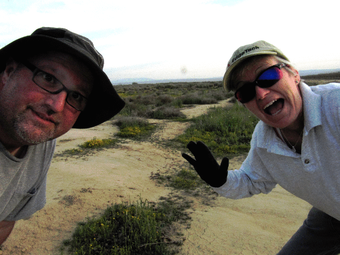
It’s like something out of a science-fiction movie: in an empty field in the middle of nowhere, hundreds of feet of wire hum with barely audible electricity. A group of scientists take a peek under the Earth’s surface, all without disturbing a speck of soil; what is revealed to them will forever change their understanding of this part of the planet. On a 1950s silver screen, mad-scientists in impeccable lab coats would have discovered an underground colony or remnants of a long-lost civilization. In the 21st century, actual real-life scientists in dusty clothes uncover the geological secrets stored underground, secrets that shape their knowledge of an area’s geological history and groundwater resources.
The technique is called electromagnetic surveying, and scientists at the California Water Science Center are using it to study geology and groundwater throughout California.

Geophysical electromagnetic (EM) surveys are something like an x-ray machine – able to create a visual of what’s beneath the skin without puncturing it. Using specialized equipment, scientists transmit an electromagnetic field (radio waves) into the ground, then measure the response that returns from the ground to a receiver. The strength of the response indicates how easily the electric current travels through the ground. This measurement is called "resistivity," and changes as the geology changes because certain minerals, rock formations, and water conduct electricity more readily than others. The data collected are processed into mapped images that give geophysicists a composition model of the earth’s subsurface.
Dr. Lyndsay Ball knows the benefits of EM surveying well. Ball is a research geophysicist at the U.S. Geological Survey Crustal Geophysics and Geochemistry Science Center in Denver, Colorado, and has been conducting EM surveys for the USGS since 2004. In September 2016, Ball was in California, heading up a geophysical study in Kern County in the Central Valley (data from this study are still in review as of July 2017).
"EM methods are non-invasive," Ball said. "They don’t disturb the ground or have minimal disturbance. They can typically be used quickly. Changes in resistivity can often be used to interpret changes in subsurface hydrogeologic conditions – so that we can map aquifer geometry, variations in groundwater salinity, and potential changes in aquifer properties like how easily water can move though the ground."

Resistivity maps can be used to understand a number of different things about geology, ranging from the 3D location of different kinds of rocks, to how much clay is present underground, to the relative salinity of the groundwater in a surveyed area. The geological structure of an area can affect groundwater in countless ways, including impeding groundwater flow into or out of aquifers, or influencing the water-quality of a basin through exposure to different rocks, minerals, or constituents below the earth’s surface. This data is useful for local water managers to better understand their groundwater resources and aquifer systems. Comprehensive understanding of groundwater resources and aquifer systems contributes to managers being better able to address current and potential future issues that may affect their water supply system, and gives them tools and data they need to create plans to ensure the long-term sustainability of groundwater resources in their basin.
The geophysical technology was originally developed for use in the mining industry to locate and map ore bodies. The technique is safely used worldwide for mineral exploration, and in the evaluation of land features and natural resources. The electromagnetic signals generated by EM systems are considerably weaker than the signals generated by natural and man-made sources (i.e. lightening, broadcast radio stations) that surround us every day.
In the past two decades, the USGS has used EM surveys to map groundwater resources throughout the world. EM surveys can be conducted either on land or from the sky! Each method shares the same technique of using a transmitter and receiver, but the process by which data is collected has its unique modus operandi and scientific benefits.
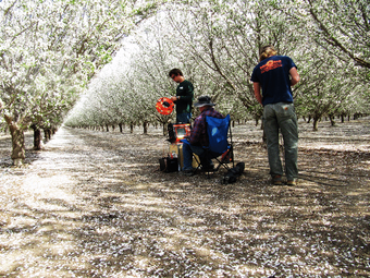
The first – and easiest – way to take geophysical measurements is to make them with two feet (and lots of equipment) solidly on the ground. To make ground-based EM measurements, scientists lay a transmitter wire on the ground in a large square, measuring up to 300 feet across. They then place the receiver system and a data logger in the center of the square. An electric current generated by small generator (batter) is pulsed through the transmitter wire. The receiver measures the returning EM fields, and the data logger records resulting data.
This method allows USGS scientists to measure electrical properties of the underground materials below the transmitter square to depths up to 1,000 feet, all without drilling a well or disturbing the ground.
"With ground-based geophysics, we can use different types of surveys to measure resistivity in different ways," Ball said. "Comparing results from different methods can help us develop better interpretations about the hydrogeologic conditions we’re really interested in knowing more about, and also helps us learn about how different hydrogeologic conditions affect the resistivity."
There are limiting factors to this technology, however. "Most electrical and EM methods are sensitive to electrical noise from infrastructure, so working in urban areas or places with lots of powerlines and pipelines, like oil fields, can be challenging," Ball said.
Electromagnetic surveys can also be conducted from the air, using low-flying aircraft and the same transmitter/receiver set up as a ground-based EM survey. The system creates a striking silhouette against the sky, with an aircraft like a plane or helicopter towing a large wire frame (imagine a gigantic hula hoop). The hoop is suspended about 100-feet below the helicopter, gliding only 100-feet above the ground. This hoop acts as the transmitter and receiver. The helicopter travels at an average of 70 miles per hour in closely-spaced parallel lines across the study area.
Using this method, scientists can cover up to 100 miles per day, collecting nearly continuous data over large areas. Signals can potentially penetrate depths up to 1,500 feet.
Because the survey is taking place in the air, AEM can cover larger areas than ground-based EM surveys, allowing scientists to see the continuity between features. This data gives scientists a more complete picture of the subsurface, allowing them to connect the dots across large areas. This large-scale dataset helps support watershed- or regional-scale studies, where single-site ground-based surveys only provide information about one site.

"Airborne platforms can also cover large areas that are difficult to access on the ground, such as wetlands, sand dunes, or other ecologically sensitive or logistically difficult areas where ground surveys aren’t feasible," Ball said. "AEM surveys do, however, require quite a bit of planning and coordination, and they take much longer to get ‘off the ground’ than a ground survey. We typically pair ground geophysics with AEM, both as part of survey planning and data analysis, so ground and airborne geophysics are a good team, not necessarily an either-or choice."
Whether in the air or on land, it’s clear that electromagnetic surveys are technologies that benefit scientific understanding of subsurface geology and aquifer systems. "Geophysical systems are evolving all the time," Ball said. "We can do a lot of things with AEM data today that we couldn’t do 10 years ago because of improved sensors – which are essentially for groundwater types of application. The limitations that we have today could be different next year, or in 10 years."