An official website of the United States government
Here's how you know
Official websites use .gov
A .gov website belongs to an official government organization in the United States.
Secure .gov websites use HTTPS
A lock () or https:// means you’ve safely connected to the .gov website. Share sensitive information only on official, secure websites.
Ten years ago, in the early afternoon of August 23, 2011, millions of people throughout the eastern U.S. felt shaking from a magnitude 5.8 earthquake near Mineral, Virginia. No lives were lost, something experts called “lucky” given the extent of shaking, but property damage was estimated to be in the range of $200 to $300 million.
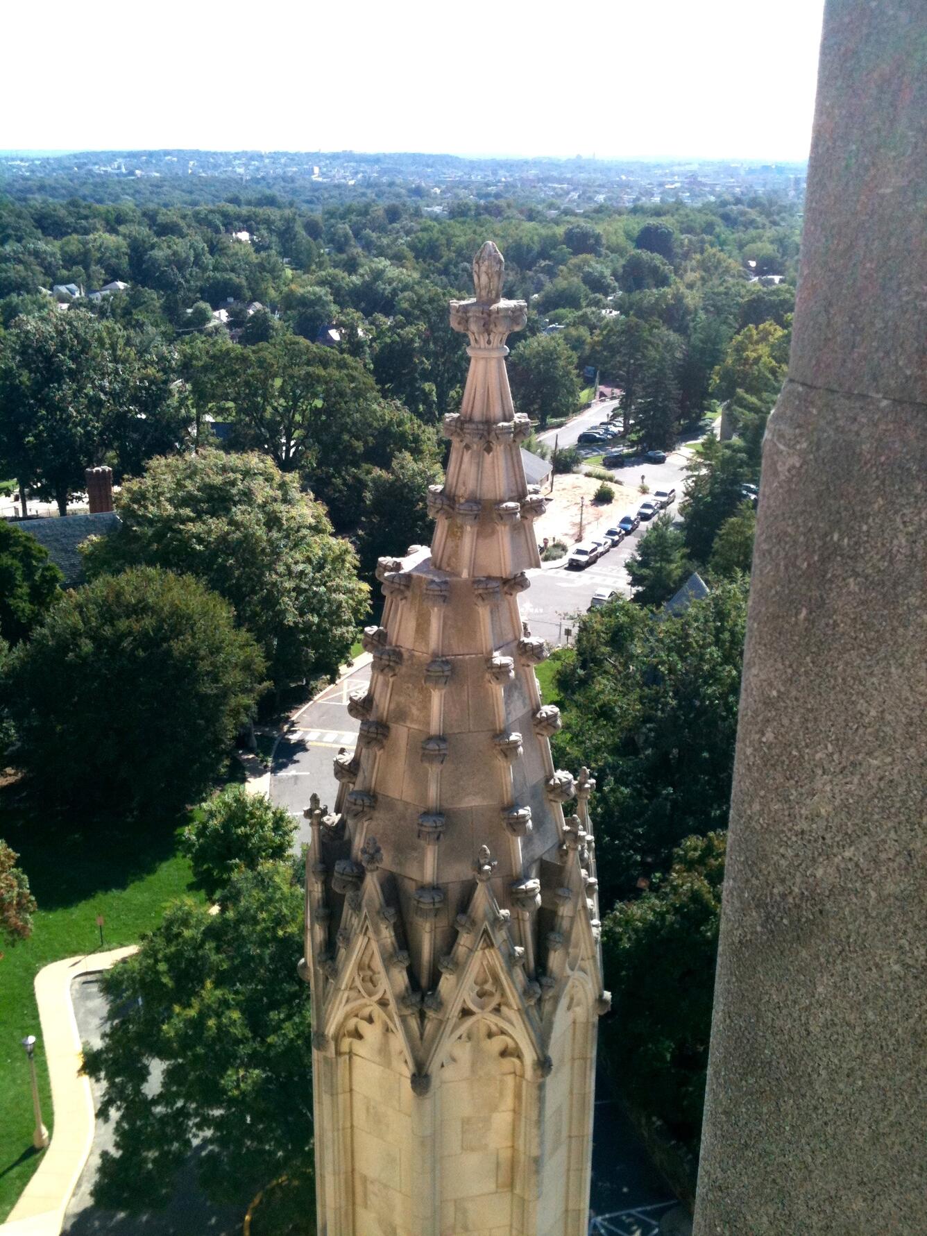
Damage to the Washington National Cathedral in D.C. from the earthquake in central Virginia on August 23, 2011. (Credit: William Leith, USGS. Public domain.)
Although not the strongest earthquake to have occurred in the eastern U.S., let alone the western U.S., the Virginia earthquake was likely felt by more people than any earthquake in North America’s history. This is due to the large distances at which people felt ground shaking and because of the density of the population in the eastern U.S.
“The 2011 earthquake in Virginia was significant in raising awareness of east coast earthquake hazards and the importance of research to understand when and where earthquakes can occur,” said David Applegate, associate director for Natural Hazards exercising the delegated authority of the Director, U.S. Geological Survey. “Damaging earthquakes do not strike the eastern U.S. often, but the potential consequences of not understanding and planning for such events with their widely distributed shaking could be severe. The next significant earthquake on an eastern U.S. fault may not occur for hundreds of years, yet there is a small chance it could happen at any time.”
Scientific studies by the USGS and partners played a critical role in helping prepare for and respond to this earthquake. The USGS is the federal government’s lead agency for assessing seismic hazards before, during and after earthquakes, providing critical information used to reduce risks to lives and property nationwide. Over the past decade, scientists have continued building on their knowledge of eastern U.S. earthquakes, specifically focusing on what can be learned from this Virginia earthquake.
“One of the fascinating things we discovered was heightened ground shaking in Washington, D.C., resulting in damage to buildings in the city at distances that would not ordinarily be expected,” said Thomas Pratt, who is a USGS research geophysicist and expert in eastern earthquakes.
Science Since the Earthquake
Heightened Shaking in Washington, D.C.
Amplified shaking was initially documented from the Mineral earthquake through detailed analyses of USGS “Did You Feel It?” reports. Each of those reports is from a member of the public describing their earthquake experience. Analyses showed that people in Washington noted stronger shaking than scientists would have expected.
“Subsequent research identified that the underlying sediment is what led to amplified shaking,” Pratt said. “We were familiar with that phenomena on the West Coast of the U.S. and internationally, but the Mineral earthquake showed the significance of this effect in the eastern U.S. The areas on sediment received significantly stronger shaking than nearby locations on firmer rock.”
The Washington Monument was damaged in the 2011 earthquake in central Virginia, but has since been repaired. (Credit: Alex Demas, USGS. Public domain.)
The USGS and partners installed temporary seismometers in the city following the earthquake to better understand the variation in the strength of shaking and its relationship to sediments beneath the city. Sediments are weaker than the underlying bedrock and therefore move more, while also trapping more energy.
Amplification by sediments has been seen in earthquakes in other areas, for example in the concentration of damage in the Marina district of San Francisco during the 1989 Loma Prieta earthquake, but the strength of this effect was not as well known for the sediments along the East Coast. It is now recognized that this amplification can be severe in the eastern U.S.
Direction of Shaking
USGS scientists found that the strength of ground shaking from the Mineral earthquake was substantially greater to the northeast than in other directions. This direction is nearly parallel to the orientation of the Appalachian Mountains and the eastern edge of the continent, which shows the influence of large-scale features like mountain ranges on ground shaking. A similar pattern was observed in the magnitude 5.1 earthquake in Sparta, N.C. in 2020, which also showed stronger shaking along the trend of the Appalachians.
Informing Decisions
Knowing the amplification caused by these sediments and the direction of shaking will help emergency managers identify communities that may be more vulnerable to shaking. This knowledge will help the USGS refine its seismic hazard maps, which estimate the strength of ground shaking that can be expected during earthquakes in each area of the country.
These insights can also be used by emergency managers when planning for and responding to disasters; state and local governments as they refine building codes; and architects and engineers as they design and renovate buildings to mitigate the effects of future earthquakes. In addition, the science helps inform planning for major infrastructure investments such as dams and reservoirs.
Earthquakes magnitude 3.5 and greater in eastern North America from 1971 to August 2, 2021. The yellow star marks the epicenter of the magnitude 5.8 earthquake August 23, 2011, near Mineral, Virginia. (Public domain.)
The earthquake occurred in what is known by scientists as the Central Virginia Seismic Zone, which has a long history of occasional earthquakes. Identifying the locations and magnitudes of past earthquakes and the likelihood of future earthquakes in the region is an area of active research.
The USGS and partners deployed portable seismographs immediately after the Mineral earthquake to supplement existing seismometers in the region for recording aftershocks. More than 450 aftershocks, including six greater than magnitude 3, were identified in the year after the earthquake, and nearly 4,000 have been recognized from subsequent analyses so far. This knowledge is helping to better understand fault lines and earthquake sources and refine estimates on the number of aftershocks that can be expected.
Within minutes of the earthquake, the USGS “Did You Feel It?” website registered nearly 150,000 responses ranging from Florida to much of southeast Canada and west to the Mississippi River Valley. The locations and strength of ground shaking were also measured on established seismic stations throughout the U.S. These data inform understanding of the distances at which ground shaking can occur from earthquakes in this seismic zone.
East Versus West Coast Earthquakes
The Mineral earthquake demonstrated how much farther ground shaking can extend in the eastern U.S. than in the western U.S. The eastern U.S. has older rocks that are harder and often denser, and faults on those older rocks have had more time to heal, allowing seismic waves to cross them more efficiently when an earthquake occurs. Another factor that increases potential risk in the eastern U.S. is that many older structures, such as buildings and bridges built before the 1970s, were not designed to endure strong shaking from earthquakes.
Map showing where ground shaking was felt from the magnitude 5.8 earthquake August 23, 2011, near Mineral, Virginia, compared to the similar sized magnitude 6 earthquake September 28, 2004, near Napa, California. Stars show earthquake epicenters, and the blue and red dots show ground shaking reported from the public to the USGS "Did You Feel It?" website. (Public domain.)
Impacts and Damage from the Virginia Earthquake
Damage caused by the earthquake was extensive. In Louisa County, Virginia, near the earthquake’s epicenter, numerous homes and buildings were damaged, with two schools being damaged badly enough to need replacement. Houses and other buildings were damaged as far away as Washington, approximately 80 miles from the epicenter. Several well-known historical structures were badly damaged, notably the Washington National Cathedral, Washington Monument and Smithsonian Institution Building, known as the Castle.
Following the earthquake, many buildings were temporarily evacuated throughout the mid-Atlantic region. The North Anna nuclear power station, located about 12 miles from the main shock epicenter, was shut down as a result of strong shaking from the earthquake. The shaking caused rockfalls as far as 150 miles away and water-level changes in wells up to 340 miles away.
Looking Ahead
The eastern U.S. is not immune to damaging earthquakes. This hazard has been known since colonial days when damaging earthquakes occurred off Cape Ann, Massachusetts, in 1755 and near Petersburg, Virginia, in 1774. The largest earthquake in the eastern U.S. was the magnitude 7 earthquake in 1886 near Charleston, South Carolina, and significant earthquakes have occurred in more recent years, such as in Delaware in 2017 and North Carolina and Puerto Rico in 2020, confirming that earthquakes can strike unexpectedly in many areas of the eastern U.S. and its territories.
There is clear geologic evidence of large earthquakes in the ancient past in eastern North America. For example, an ancient earthquake with a magnitude likely in the high 6 to 7 range ruptured a fault at the surface beneath Washington, D.C., leaving geologic evidence that is still visible in a road cut near the National Zoo. This earthquake may have occurred as much as 400,000 years ago, and the chances of a repeat in the near future are extremely small, but a similar or even smaller earthquake today could greatly impact the city and nation.
While earthquakes in this region occur less frequently than other natural hazards such as severe storms and floods, the impact of a large earthquake could equal or exceed the damage inflicted by other natural disasters. Check out FEMA’s Ready campaign for tips on earthquake preparedness.
A Historical Precedent
August 2021 also happens to be 135 years to the month since the largest historical earthquake in the eastern U.S. struck Charleston in the late evening of August 31, 1886. This earthquake was felt throughout most of the central and eastern U.S. It caused the loss of more than 100 lives and many buildings collapsed or were heavily damaged. Afterwards, the newly established USGS conducted one of its first post-earthquake investigations, resulting in the publication of a scientific description of extensive damage throughout the area. The 2011 Mineral earthquake raises the question of whether, or more precisely when, a repeat of the 1886 earthquake will occur near Charleston, or whether a similar earthquake might strike another major city in the central or eastern U.S.
The Next East Coast Earthquake – Are You Ready?
Mark your calendar and participate in The Great SouthEast ShakeOut, part of one of the biggest earthquake drills in history. On October 21, 2021, at 10:21 a.m. participants will “drop, cover and hold on.” This will be a chance to become better prepared and practice what to do if an earthquake happens in your community.
USGS infographic on the magnitude 5.8 earthquake that struck central Virginia in 2011, east coast earthquake hazards and how the USGS is helping inform critical decisions to protect lives and property. (Public domain.)
Photo of chimney damage at a house in Louisa County, Virginia. This was a result from a magnitude 5.8 earthquake in Virginia August 23, 2011. (Credit: Francis Ashland, USGS. Public domain.)
Damage to the Washington National Cathedral in D.C. from the earthquake in central Virginia August 23, 2011. (Credit: William Leith, USGS. Public domain.)
USGS scientists inspect rocks in Louisa County, Virginia, near the epicenter of the 2011 earthquake. Scientists analyze rock features to help identify past earthquakes and movements along the Central Virginia seismic zone. (Credit: Mark Carter, USGS. Public domain.)
USGS infographic on the magnitude 5.8 earthquake that struck central Virginia August 23, 2011, east coast earthquake hazards and how the USGS is helping inform critical decisions to protect lives and property.
Full Text Description:
10-YEAR ANNIVERSARY OF THE M5.8 EARTHQUAKE IN VIRGINIA America’s Most Widely Felt Earthquake