
2018 Anchorage Earthquake
This is a developing story, so please keep checking for updates
A magnitude 7.0 earthquake struck north of Anchorage, Alaska, on November 30, 2018, at 8:29 a.m. local time (17:29:28 UTC). For the most up-to-date information, please visit the USGS event page, and for estimates of casualties and damage, visit the USGS Prompt Assessment of Global Earthquakes for Response (PAGER) website.
U.S. Geological Survey scientists continue to investigate the magnitude 7.0 earthquake that rocked south-central Alaska on Friday, now being referred to as the "2018 Anchorage Earthquake." A team of earthquake and landslide geologists from multiple USGS science centers is mobilizing to conduct field reconnaissance in Anchorage in the aftermath of this most recent event, and they are coordinating their activities with state and university colleagues. Another team will be collecting structural monitoring data from buildings and deploy a temporary network to study basin effects.

The USGS is working closely with Alaskan state scientists and emergency managers. Right now, aftershocks are at the forefront of discussion. USGS scientists know that there will be more aftershocks and some will be larger than others, but the aftershocks will decrease in frequency over time. As of December 3rd, 15:00 UTC, 170 aftershocks of magnitude 3 or above have occurred since the mainshock, including a magnitude 5.7 aftershock at 17:35 UTC on November 30th, just 7 minutes after the magnitude 7.0 mainshock. USGS and other scientists cannot predict the exact time, location and magnitude of any specific earthquake.
This earthquake occurred in the Alaska-Aleutian subduction zone, on a fault within the subducting Pacific slab rather than on the shallower boundary between the Pacific and North American plates. The earthquake was not related to movement of a fault near the Earth’s surface. This earthquake is perhaps most similar in setting to the magnitude 6.8, 2001 Nisqually earthquake, which occurred near Seattle, and caused between 1 and 4 billion dollars in damages.
"Even as we recover from the impact this event had on our families, friends and neighbors, USGS is leading post-earthquake surveys and investigations,” said Aimee Devaris, USGS regional director for Alaska. “This research will allow us to build on our scientific understanding of earthquake hazards and how best to plan for, respond to and recover from large earthquakes."
Since the 1964 Alaskan earthquake, a magnitude 9.2, Alaska has had 144 earthquakes above magnitude 6.

What will happen next?
According to our forecast updated on December 3d, 2018, over the next week there is a 3 percent chance of one or more earthquakes that are larger than magnitude 7.0. It is likely that there will be many smaller earthquakes over the next week, with 47 to 110 magnitude 3 or higher aftershocks expected. Magnitude 3 and above are large enough to be felt. The number of aftershocks will drop off over time, but a large aftershock can temporarily increase the numbers again. The most current forecast can be found on the 2018 Anchorage Earthquake aftershock forecast page, along with other information about this earthquake.
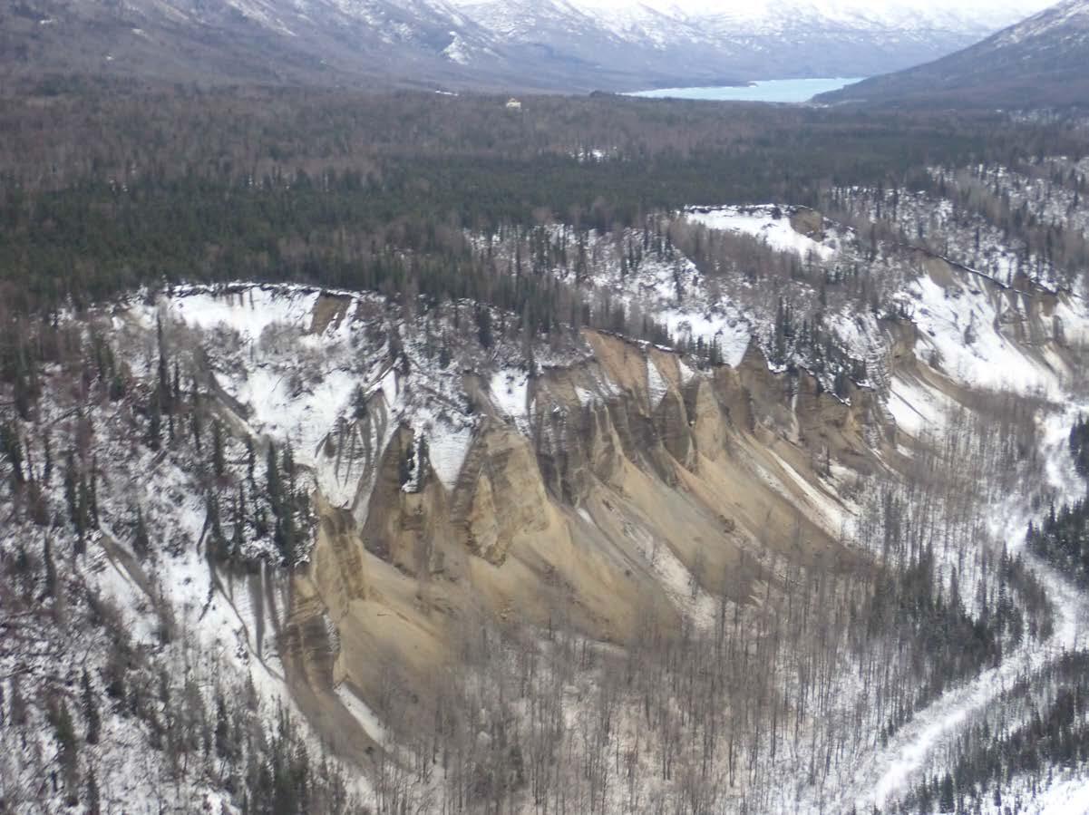
Liquefaction and landslides
Large earthquakes can create many hazards such as liquefaction and landslides. The USGS has added near-real-time estimates of such ground failures for this earthquake event. This is the first major earthquake in the United States for which this product is available. The models indicate that liquefaction and landsliding have likely occurred and may be responsible for damage to infrastructure, with liquefaction potentially being the larger issue. While these models are relatively simple, initial reports support these conclusions.

Dramatic examples of ground failure have occurred in previous earthquakes in Alaska, such as the 1964 magnitude 9.2 Great Alaskan earthquake, and the 2002 magnitude 7.9 Denali earthquake. The shaking intensity of this event is smaller than in those historical events. So although USGS scientists expect ground failure to contribute significantly to the impact of this earthquake, the occurrence of ground failure will not be as severe or extensive as in those events. Liquefaction models suggest potential impacts in localized areas throughout Anchorage and in the Matanuska valley. Liquefaction hazard is also high in low-lying areas of wet sediments elsewhere, though the human population is sparse. Still, ground failure in these areas could cause infrastructure impacts.
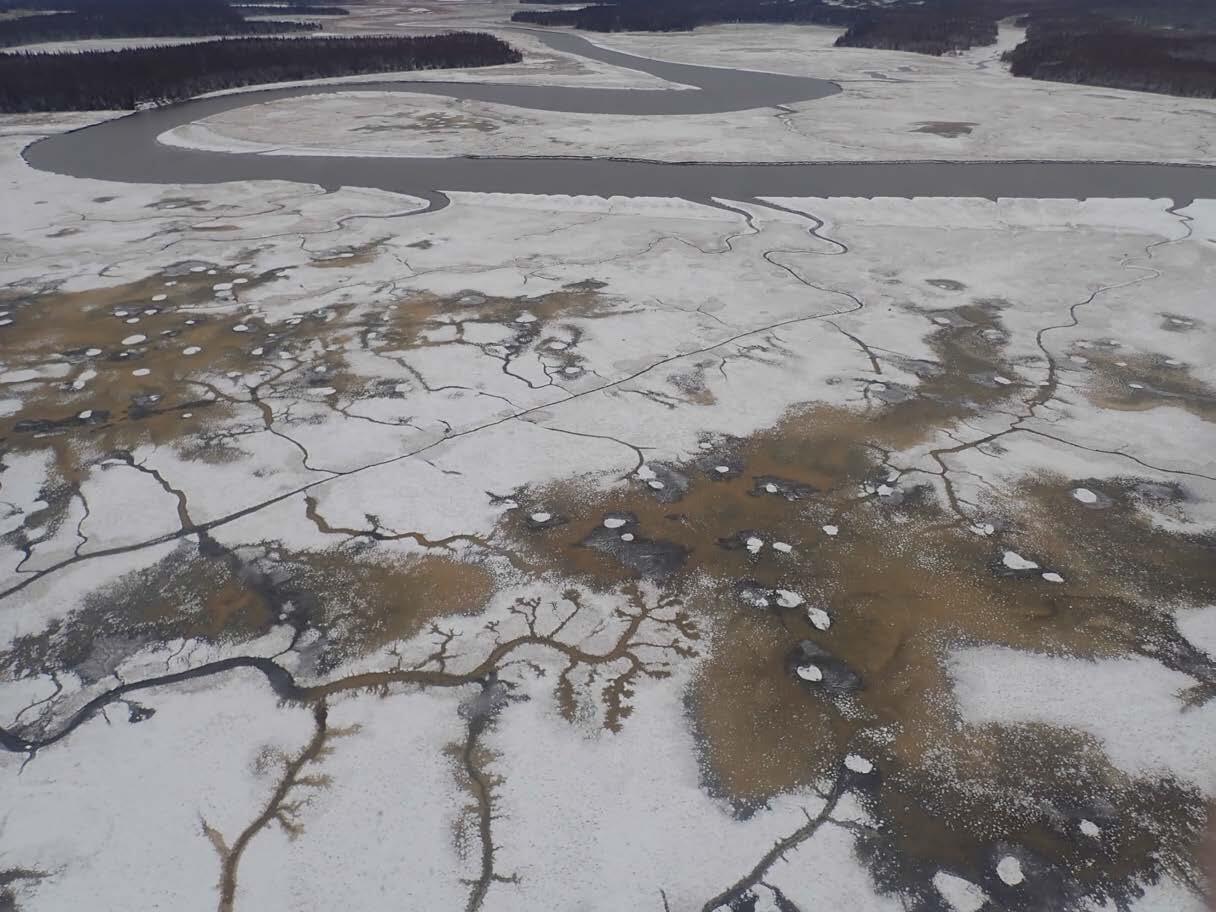
Cracks may form in the ground and the ground may move horizontally, known as lateral spreading. This is possible in areas susceptible to liquefaction that are sloped or near cut banks of waterways. Models suggest landslides likely occurred throughout the western part of the Chugach mountains. Coastal bluffs and other steep areas and manmade fill could also be affected. Ground failures are unlikely to recur after the mainshock, but aftershocks greater than about magnitude 6 could reactivate existing failures or cause new failures in ground that was weakened by the mainshock.

More information
If you felt this earthquake, report your experience on the “USGS Did You Feel It?” website for this event.
For information about tsunami watches, warnings or advisories, visit the National Oceanic and Atmospheric Administration (NOAA) tsunami website.
The USGS operates a 24/7 National Earthquake Information Center in Colorado that can be reached for more information at 303-273-8500.
Learn more about the USGS Earthquake Hazards Program.
The Alaska Earthquake Center (AEC) at the University of Alaska Fairbanks is a regional seismic network that participates in the USGS Advanced National Seismic System. AEC contributes seismic monitoring data and conducts analyses that are used in characterizing the 2018 Anchorage earthquake and its aftershocks.