Seeing Water from Space
Satellites Empower Flood Preparedness
Picture a remote Alaskan town connected to the outside world by a single bridge spanning a wild river. When massive ice blocks dam up rivers and then suddenly break free, the resulting floods can surge without warning and wash out that critical crossing, leaving an entire community stranded — cut off from supplies, medical care, and emergency services.
This scenario plays out across Alaska's rugged wilderness, where the Department of Transportation manages over 5,600 miles of highways and 839 bridges. Most of these wild lands don’t have flood monitoring capabilities.
Now, new satellite technology is changing that reality.
Satellites are helping remote communities like these protect themselves from flooding disasters by providing reliable access to water level data. For the first time, vulnerable neighborhoods can monitor their local waterways with comprehensive information that was previously unavailable, giving them critical insights to improve flood preparedness.
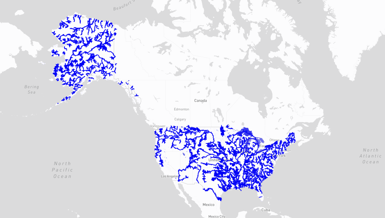
This breakthrough comes through a new web application called Water Information from Space, or WISP, recently launched by the U.S. Geological Survey. The satellite-powered tool is transforming how communities understand and analyze their water systems, providing valuable data for flood recovery, infrastructure planning and long-term water resource management across America.
"When communities have better information about their water resources, they are empowered to better protect themselves—whether that's through improved emergency plans, smarter development decisions, or more resilient infrastructure design," said Merritt Harlan, USGS scientist and WISP program lead.
Unveiled in November 2024, WISP harnesses data from NASA's Surface Water Ocean Topography satellite to monitor water levels across more than 467,000 lakes and reservoirs and approximately 93,000 miles of river networks throughout the United States. The SWOT mission was jointly developed by NASA and Centre National D'Etudes Spatiales with contributions from the Canadian Space Agency and United Kingdom Space Agency.
Revealing Hidden Flood Impacts Across America
The system has already proven its value during recent flooding events. Between February and April 2025, satellites detected water level rises of 5.7 feet in a pond near Tushka, Oklahoma, helping to monitor the extent of recent flooding in the area.
"For the first time in history, we can track water levels on large rivers and lakes anywhere in the nation—seeing water level changes in remote areas where we've never had monitoring capabilities before," Harlan explained. "The USGS-NASA partnership brings space-age technology down to Earth in ways that directly benefit remote communities."
The technology is especially valuable for monitoring high-hazard dams—structures where failure could lead to loss of life in downstream communities. By incorporating WISP's satellite observations, engineers can improve spillway warning systems, reducing both false alarms and dangerous oversight
failures.
Seeing the Invisible: Tracking Water Where No Gauges Exist
Back in Alaska, where traditional monitoring has been impossible across vast wilderness areas, WISP is revolutionizing infrastructure protection. Engineers previously had to design critical crossings with significant knowledge gaps, working with limited information in landscapes where water can be the difference between connection and isolation.
"For projects in remote areas, water data useful to hydraulic design tasks is often limited,” said said Michael Knapp, Statewide Hydraulic Engineer at the Alaska Department of Transportation & Public Facilities. “With the USGS WISP application, we're gaining insights into river systems never before monitored in Alaska's history.”
This satellite data helps create more resilient infrastructure that can withstand Alaska's extreme seasonal water conditions—ultimately providing safer travel for communities dependent on these vital transportation lifelines.
Global Implications for Water Security
While currently focused on U.S. waterways, the technology behind WISP represents a potential breakthrough for global water resource monitoring. In developing nations where ground-based monitoring infrastructure is limited, satellite observation could provide crucial data for flood warnings, drought monitoring and water resource management.
Your Water Data at Your Fingertips
The free, publicly accessible tool makes it easy for anyone to track water conditions in their community. Users can browse water data through an interactive map, search by location or water body name, and download time series information for research or planning purposes.
To get started, simply visit the WISP website, enter your location or a nearby water body in the search function, and explore real-time and historical water level data. The intuitive interface allows users to zoom in on specific areas, view data trends over time, and access downloadable datasets for deeper analysis.
To discover how WISP can help track real-time water levels in your community, visit the USGS WISP application website.