
Tracking down commodity sources: The surprising role geoscience can play in assisting U.S. foreign policy
Since 2006, the USGS has collaborated with several international organizations working to track and monitor illegal mining and armed groups funded by mineral resources around the world.
Faced with armed conflicts that challenged American interests across Africa, the State Department turned to a surprising ally: science. In 2006, African civil wars were fueled by “blood diamonds” as rebels and non-state actors seized control of mining and rough diamonds. That’s what prompted officials at the State Department to request USGS expertise to track down mineral sources, production, and exports to help trace the source of diamonds and legality of their production.
“The USGS science is essential to the diplomacy work we do at the State Department,” said Foreign Affairs Officer Rebecca Nolan, who worked with USGS staff on compliance with the Kimberley Process to reduce conflict diamonds.
The Kimberley Process is an international initiative to increase transparency and oversight in the diamond industry to eliminate trade in conflict diamonds.
“The science was agnostic, but it showed the value of the minerals, which advanced conversations with the Kimberley Process about how to move forward,” Nolan added.
Since 2006, the USGS has collaborated with several international organizations working to track and monitor illegal mining and armed groups funded by mineral resources around the world. As armed groups turned to other minerals to fund their activities, USGS expertise was tapped to trace illegal trade in additional commodities including gold, tin, tantalum, tungsten, rubies, and jade. It’s also been applied to industrial minerals like sand and gravel.
Here’s where the science comes in: USGS scientists help detect where illegal mining is likely taking place and develop realistic production numbers to determine a country’s true capacity for mining and exporting mineral resources. This knowledge helps identify differences between what can be produced versus what is being exported and whether miners are crossing borders to illegally mine and sell resources.
Ben Wiselogle, the State Department’s Desk Officer for the Central African Republic, worked with Dr. Peter Chirico, Associate Director of the USGS Florence Bascom Geoscience Center, to gain a better understanding of natural resources in the Central African Republic.
The USGS satellite imagery, analyzed with knowledge of geology and geography, can help countries understand their natural resources. Wiselogle shared more on his perspective of the benefit of the USGS science: “The USGS science unlocks the ability to develop and ground good policy in facts and informs helpful political frameworks.”
In 2013, the rough diamond trade provided resources that fueled a civil war in the Central African Republic (CAR). The State Department requested that the USGS conduct an assessment to monitor mining activity and diamond exports. In 2018, the USGS scientists calculated that more than 330,000 carats of diamonds are mined annually, and more than 80 percent are illegally exported or smuggled from territory not controlled by the CAR government.
Wiselogle explained, “The goal is not to get countries in trouble, but to ensure the supply chains are legitimate. The idea is for CAR to benefit from the natural resources it has, and to protect human and environmental health in the process. The USGS science can help map and understand those resources.”

Dr. Chirico and the USGS studied the geomorphology and mineral deposits of CAR to determine where small informal diamond mines were located and how much was being mined or produced from each of those mines. This information helps the State Department understand mining and trading of diamonds throughout different regions in CAR – some in the midst of conflict and others not. The State Department was able to determine where the diamond trade was most susceptible to armed conflict concerns and illegitimate trading of diamonds that might fuel conflict.
The USGS science has improved transparency of artisanal mining in CAR and beyond.
CAR is not the only country where the USGS science is informing diplomatic efforts related to resources. As referenced in this USGS Featured Story, the USGS also works in Guyana, Guinea, Côte d'Ivoire, and additional countries throughout Africa, South America, and Asia.
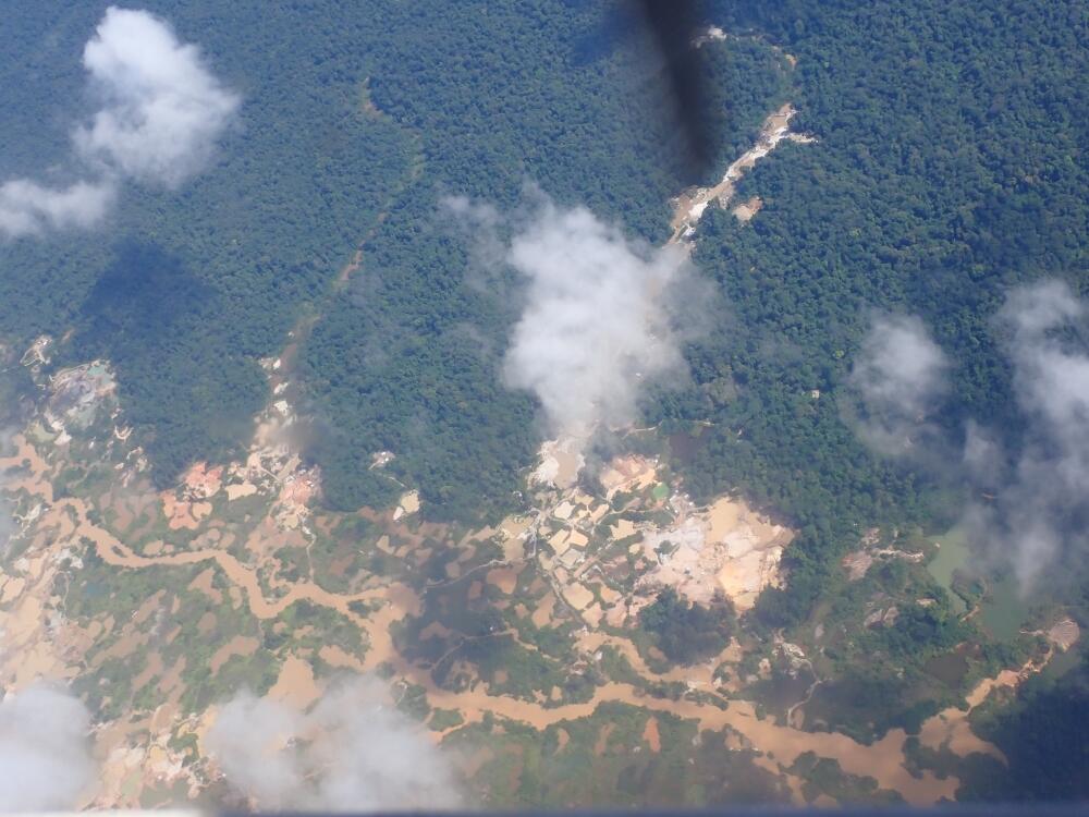
In Guyana, illegal mining and export of gold are concerns. At the Guyanese government’s request, the USGS and the U.S. Embassy, in collaboration with Guyana’s Ministry of Natural Resources, began a project in 2021 to help document nationwide artisanal and small-scale gold mining. They identified mining sites and associated deforestation using satellite imagery and field studies. Identifying unpermitted mining locations helps the Guyanese government address illegal mining and mercury contamination, as mercury is often used in the gold mining process but can negatively impact human and environmental health.
The USGS science is able to inform policymakers’ decisions about human and environmental health in these scenarios.
“The USGS expertise is helping our embassy achieve three priority goals, which are to encourage good governance, enhance security, and promote prosperity,” said Sarah-Ann Lynch, former U.S. Ambassador to Guyana.
New high-tech mineral mapping in Guyana aims to reduce the barriers to gold prospecting and also to help preserve the environment. The project harnesses the USGS technology and “could support strategies to rehabilitate and restore areas already affected by mining, ensuring Guyana’s ecosystems are preserved for future generations,” said Nicole Theriot, U.S. Ambassador to Guyana.
The efforts could also support further economic development in Guyana, without fueling conflict or more seriously degrading natural resources.
The State Department, the USGS, and additional collaborators have come a long way in supporting ethical mineral supply chains, but there is always room for additional work. Rebecca Nolan from the State Department explained that she would like to see future studies in which the USGS scientists use their expertise, in an ongoing basis, to identify where minerals mined by artisanal miners are coming from, especially if there are conflict or criminal concerns in those areas. That way, the countries of mining origin will benefit from their mineral exports, and the companies who rely on the minerals for their products will know the origin when they make the purchase.
To learn more about conflict mining, readers can visit the National Museum of American Diplomacy, and in particular, the conflict minerals section of the museum. There is a virtual display, and the museum is open to the public via educational group tours.
This story is part of a series showcasing how bureaus within the Department of the Interior produce and apply science to ensure better outcomes for the American people.