
When Ice Yields Fire
How USGS Explores the Cutting Edge of Gas Hydrates
When can ice yield fire? That’s the burning question at the heart of one of USGS’s longest-running research programs to date: the exploration of gas hydrates.
What are Gas Hydrates?
Gas hydrate forms when water and natural gas combine under specific pressure and temperature conditions to make an ice-like solid. The water forms a crystalline cage that traps the gas in such a way that the hydrate can contain quite a lot of gas. Gas hydrates are known to be widespread in permafrost regions and beneath the sea in sediments of outer continental margins.
Methane, the primary component of natural gas, is the most common of the gases that form gas hydrate. In fact, the amount of natural gas within the world’s gas hydrate accumulations is estimated to greatly exceed the volume of all known conventional gas reserves. Because of that potential, the USGS and academic, government, and private industry scientists and engineers have for many decades been studying how to produce natural gas from hydrate formations.

Foundations of Gas Hydrate Research
The potential for water to form hydrates with a gas was first discovered in the early 1800s, but the natural occurrence of gas hydrates wasn’t discovered until the 1960s in Siberia. In the 1980s the U.S. Geological Survey (USGS) and the U.S. Department of Energy (DOE) began a partnership to explore the possibility of producing natural gas on a large scale from hydrate deposits.
Since then, USGS, DOE, and many other domestic and international groups have conducted a growing number of field tests, laboratory studies, and geophysical analyses in many places around the world to determine the distribution of gas hydrate and the conditions under which production of natural gas from hydrate would be possible.

Probing the Permafrost
The U.S. Arctic has been a particular focus for USGS and its partners due to relative accessibility of the widespread gas hydrate deposits within the permafrost of the Alaskan North Slope. Following involvement in test wells drilled at Mallik in Canada’s Mackenzie River Delta, USGS participated in the development of a research consortium to drill the Mt. Elbert prospect near the giant oil fields of Prudhoe Bay in 2007. The USGS used samples retrieved during the drilling to conduct exhaustive research on the sediment properties controlling the distribution of gas hydrates on the North Slope.
With the support of the U.S. Bureau of Land Management (BLM), the USGS used the results of the Mt. Elbert test well to complete the first-ever assessment of natural gas resources that are technically recoverable from hydrate deposits. A technically recoverable deposit is one from which gas can be produced using current technology.

In 2008, USGS announced that the Alaska North Slope contained an estimated 85.4 trillion cubic feet of technically recoverable natural gas resources in the form of gas hydrate. Although no commercial production has begun, the underlying approach to geophysical and geological analyses for that assessment has been used by private companies and other government and academic scientists to guide gas hydrate research in other parts of the world.
The USGS is in the process of updating the assessment of gas hydrate resource potential for the Alaska North Slope based on advances that have occurred since 2008. In parallel with the resource assessments being led and supported by the USGS, BLM, and the U.S. Bureau of Ocean Energy Management (BOEM), the USGS is performing a life-cycle analysis of five North Slope gas hydrate fields, modeling how much natural gas might be produced, the potential impacts of production on the environment, and the economic implications of such production.
Analyzing the Abyss
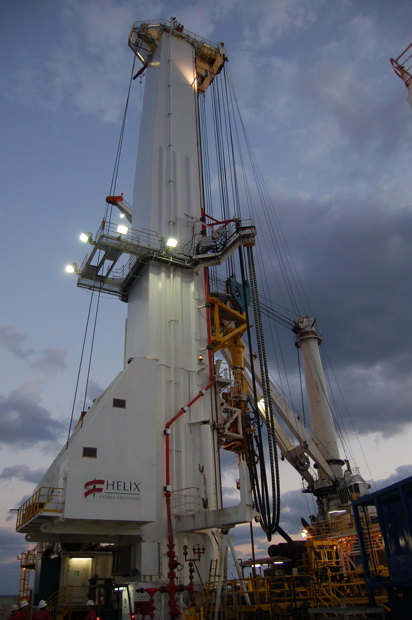
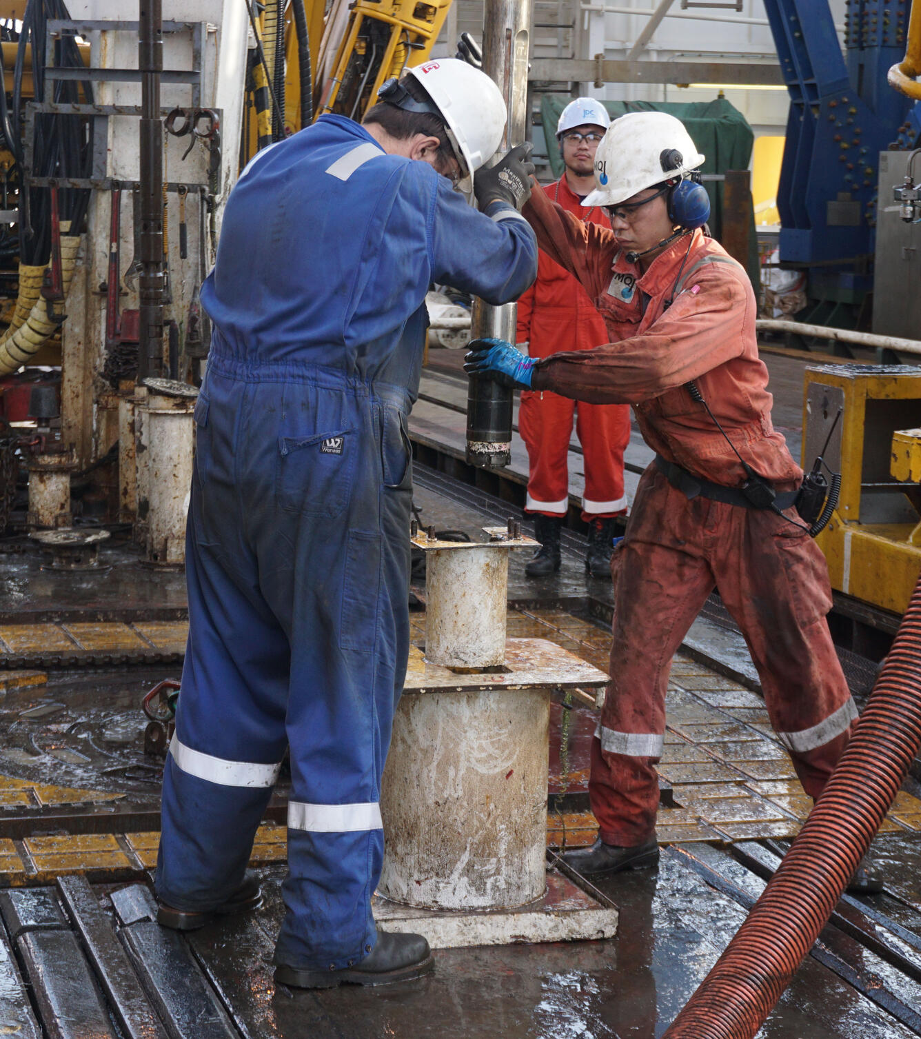
In deepwater gas hydrate settings, the USGS has since 2005 participated in three major expeditions to drill test wells in the northern Gulf of Mexico. These research test wells have provided details about the formation and concentration of gas hydrates in deep ocean sediments and about the potential of gas production from such deposits. In 2005 and 2009, the research test wells were drilled by a group led by the DOE, USGS, BOEM, and U.S. and international energy industry partners under the direction of Chevron. These test wells confirmed that high-concentration gas hydrate deposits that could potentially produce recoverable gas existed in the northern Gulf of Mexico.
In 2017, DOE sponsored a follow-up expedition led by the University of Texas at Austin in the northern Gulf of Mexico and tested pressure coring equipment to recover hydrate-bearing sediments at their in situ (deep seafloor) pressures in order to maintain the gas hydrate intact. Pressure coring technology has advanced rapidly since the mid-1990s and has previously been used for both U.S. and international gas hydrates drilling programs. The 2017 expedition marked the first extensive use of pressure coring in the northern Gulf of Mexico and involved researchers from the USGS, Geotek, Ltd., and other organizations.

A Partner under Pressure
The Hydrate Pressure Core Analysis Laboratory (HyPrCAL) is the newest USGS Gas Hydrates Project facility and supports some of the Project’s energy research at the Woods Hole Coastal and Marine Science Center. HyPrCAL was the first facility in the U.S. solely designed for and dedicated to the analysis of pressure cores. The laboratory is currently analyzing hydrate-bearing pressure cores from the Indian Ocean. Pressure coring not only retrieves hydrate-bearing samples at their seafloor pressure conditions, but also allows the recovered cores to be held at high pressure in cold storage, thereby preventing breakdown or dissociation of the gas hydrate. The USGS HyPrCAL facility is studying the strength, permeability, electrical and thermal properties of pressure cores and conducting benchtop tests to monitor gas production during controlled dissociation of gas hydrate.
Gas Hydrates around the Globe
USGS scientists contribute geological, geophysical, and geochemical expertise to U.S. and international gas hydrate research and have accumulated decades of experience as participants in and leaders of field expeditions, laboratory research, and modeling efforts. For these reasons, the USGS is often a partner in international gas hydrates research, contributing to projects on the U.S. and Canadian Pacific margins, offshore South Korea, in the Nankai Trough offshore Japan, and in the Indian Ocean.
Beginning in 2006, USGS scientists partnered with the Indian Government, as well as other scientists and engineers from the United States and Japan, to evaluate the gas hydrate potential of the northern Indian Ocean. The first expedition found several sites with gas hydrates, but they did not appear likely to be producible. In 2015, the second expedition discovered several large, highly enriched accumulations of gas hydrate that are likely to be producible. As noted above, several pressure cores obtained during that expedition are being analyzed at the new USGS Hydrate Pressure Core Analysis Laboratory.
Another highlight was USGS involvement in the 2010 Ulleung Basin gas hydrates project in the East Sea of Korea. The expedition not only confirmed that gas hydrates existed there, but also identified several accumulations that hold promise for production. The USGS is currently collaborating with South Korean scientists to study properties of sediments obtained during that expedition’s coring program.

Start with Science
Substantial resources are required to study gas hydrate prospects in deepwater and Arctic settings, and years of effort must be expended to prepare the scientific data used to plan gas hydrate expeditions and then to analyze data and samples collected from these expeditions. Collaboration within the USGS, within the U.S. federal government, and with outside partners is therefore essential to the success of the USGS Gas Hydrates Project.
Within the USGS, the Gas Hydrates Project is jointly supported by the Energy Resources Program and the Coastal and Marine Geology Program, with scientists based at several USGS offices. Beyond the USGS, the U.S. Department of Energy manages the federal Methane Hydrates Research and Development Program. The USGS is a close partner with DOE, as well as with BOEM and BLM within the U.S. Department of the Interior, in many energy-related gas hydrate projects and also works with state agencies in Alaska and numerous universities. The USGS also frequently collaborates with international partners like the Japan Oil, Gas and Metals National Corporation, the Geological Survey of Canada, the National Gas Hydrate Program of India, and the Korean Gas Hydrate Development Organization to share expertise to advance energy-related gas hydrates objectives.
The lessons learned through USGS involvement with these partners and through a wide range of field, laboratory, and modeling programs inform research on the U.S. domestic gas hydrate resource. Although commercial production of gas from hydrate deposits has not yet begun, if it comes to pass, it will be rooted in the foundation of decades of research led by scientists at the USGS.

Read More