M3.9 earthquake and swarm occur at Mount Hood on June 5, 2021
The M 3.9 earthquake occurred at a depth of 2.7 miles below sea level. At this time, seismologists do not believe the earthquake swarm signifies a change in volcanic hazard at Mount Hood, and will continue to monitor the swarm and issue updates as the situation warrants.
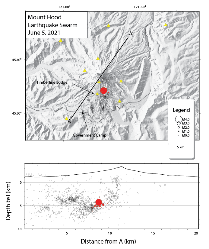
At 20:51 PDT on June 5 (0351 UTC on June 6) a Magnitude 3.9 earthquake occurred about 2.5 mi (~4 km) south of the summit of Mount Hood, Oregon, at a depth of 2.7 mi (4.3 km) below sea level. The earthquake was felt in areas around Mount Hood.
The swarm was preceded by several earthquakes in the hour prior to the M 3.9, and tens of aftershocks have occurred with event rates declining in a manner typical of mainshock-aftershock sequences. The mainshock characteristics and location are consistent with past swarms in the Mount Hood area, including a M 4.5 on June 29, 2002, that was located ~1 mi (~1.6 km) east of the M 3.9. Aftershocks will likely continue for hours or days, some of which may be felt.
At this time, seismologists at the Cascades Volcano Observatory and Pacific Northwest Seismic Network do not believe this swarm signifies a change in volcanic hazard at Mount Hood, but will continue to monitor the swarm and will issue further updates as the situation warrants.
MOUNT HOOD VOLCANO (VNUM #322010)
45°22'26" N 121°41'42" W, Summit Elevation 11240 ft (3426 m)
Current Volcano Alert Level: NORMAL
Current Aviation Color Code: GREEN
Resources:
- USGS CVO Mount Hood Information Statement.
- USGS Did You Feel It event webpage.
- Images, graphics, and general information about Mount Hood.
- Pacific Northwest Seismic Network seismic information about Mount Hood.
- Information on USGS volcano alert levels and notifications.
- Sign up to receive volcano notification emails through the Volcano Notification Service.
- Shake Alert.