
Planetary Mapping an Undeniable Tradition at ASC
Planetary geologic mapping began in 1962 at the U.S. Geological Survey (USGS) and continues today at the Astrogeology Science Center (ASC). Geologic maps depict the distribution of rocks and sediments at the surface of a planet. They provide a standardized, easy-to-interpret format to assist both scientists and enthusiasts in understanding the geologic evolution of a planet.
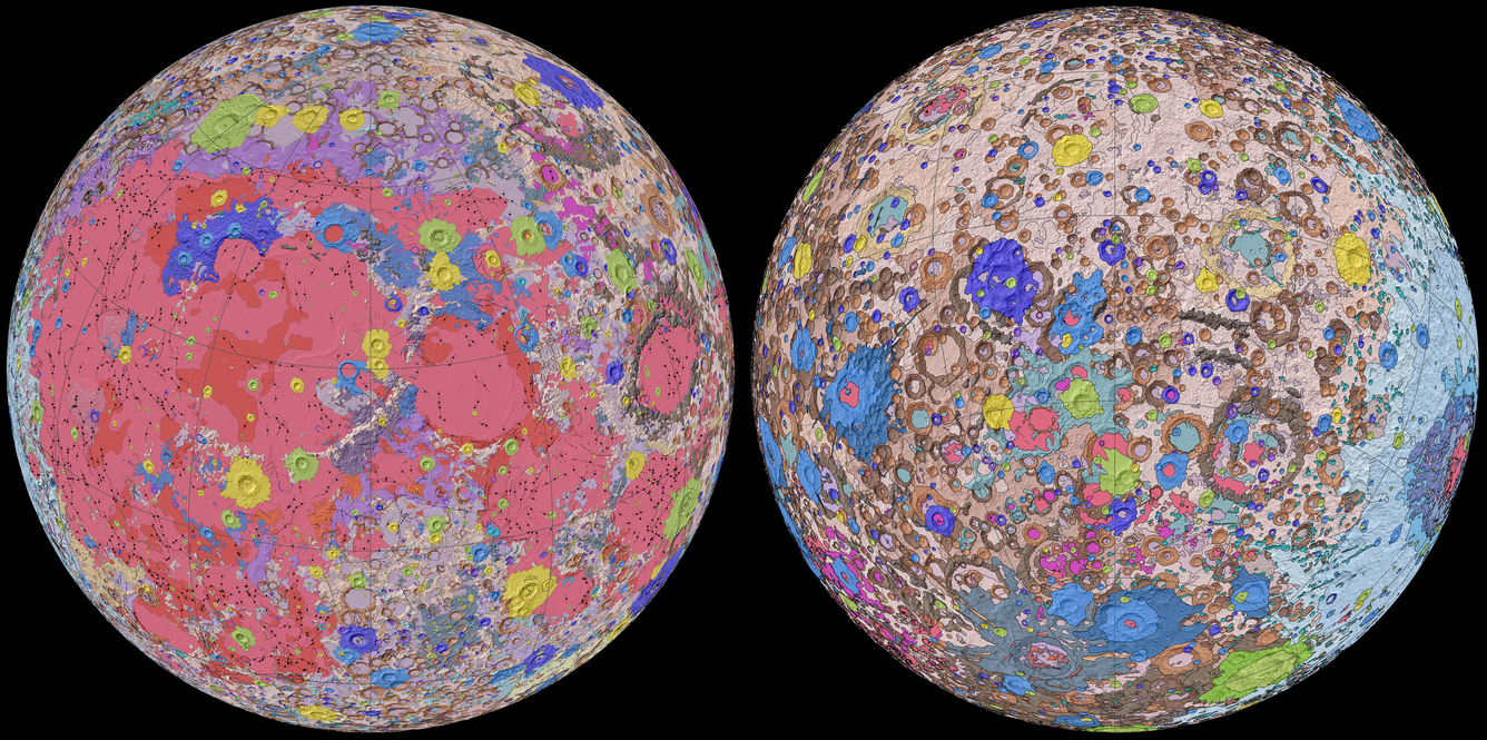
Cartography is the study and practice of making maps. Geologic mapping is a combination of careful science and subjective as well as aesthetic decision-making on the part of the cartographer. Maps are a simplified and imperfect depiction of the real world, so all maps contain some subjectivity. For example, the Unified Geologic Map of the Moon map consists of six complex Apollo-era regional geologic maps that were skillfully combined and updated based on data from recent satellite missions. Another recent product is our surface image map onboard NASA's Mars 2020 spacecraft slated to land in Jezero crater, Mars, on Feb. 18, 2021. The map will help guide the rover to a safe place to land in an automated manner.
How we began:
Astrogeology Science Center’s (ASC) founder, Eugene Shoemaker, mapped the Copernicus region of the Moon, in 1962, using an image captured with a telescope by Francis Pease as a map base. This map was the impetus of initiating a geologic map program. We have mapped numerous planetary bodies since, at a variety of scales and projections using the best available images and topographic bases.

Mapmaking in the distant past:
Until the early 1990s, geologic map bases commonly consisted of hand-mosaicked photographs or airbrushed shaded-relief views. Geologic linework was drawn on a type of transparent film using a pen with a needle-point tip that is suitable for drawing very fine lines. Map publishing required the tedious process of scribing, typesetting, and photo-laboratory work.
Mapmaking today:
Today, mapping is done on computers using digital basemaps created from spacecraft imagery. Geologic maps published by the USGS presently are primarily digital products using geographic information system (GIS) software and file formats. New technology has allowed maps to be published, for example, through a GIS platform. GIS is invaluable for mapping planetary data, and the technological advancement of such software has facilitated and continues to evolve mapmaking.
Recent Planetary Maps:
Earlier this year, ASC released a new global geologic map called the Unified Geologic Map of the Moon. “So, it’s wonderful to see USGS create a resource that can help NASA with their planning for future missions,” current USGS Director and former NASA astronaut Jim Reilly said of the map. The map will serve as the definitive blueprint of the Moon’s surface geology for future human missions and will be useful to the international scientific community, educators, and the public-at-large.
ASC also produced a precision image map of the surface of Jezero crater, Mars, which will be onboard NASA’s Mars 2020 spacecraft. This map will be used to help the Mars 2020 spacecraft determine a safe landing spot within Jezero. Since Mars is so far away, people cannot command the spacecraft in real time during the landing sequence. So, the entire process must be automated. “As much as we would love to manually steer the spacecraft as it lands, it’s just not possible,” said Robin Fergason, USGS research geophysicist and leader of the team that created the maps. “Mars is so far away -- some 130 million miles at the time of landing -- that it takes several minutes for radio signals to travel between Mars and Earth. By using the maps we created, the spacecraft will be able to safely steer itself instead.”

The creation of planetary geologic maps is supported by NASA funding. For decades to come, ASC will continue to make maps designed to best serve the needs of our customers such as NASA missions and our scientific community.