
Land Treatment Exploration Tool Version 2.1 Launch
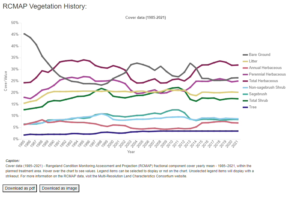
New features include updated data inputs, new data sources, and a new figure that displays annual vegetation cover for planned treatment polygons.
The U.S. Geological Survey partners with the Bureau of Land Management to create and maintain the Land Treatment Exploration Tool to facilitate adaptive management of land treatments. The Exploration Tool taps into the Land Treatment Digital Library, a catalog of information about all known treatments on public lands administered by the BLM in the western United States.
The U.S. Geological Survey launched an updated version (2.1) of the Land Treatment Exploration Tool to improve user experience and incorporate new, cutting-edge data sources.
These sources include:

In addition, a new feature in the Site History tab of the tool displays annual estimates of vegetation cover for the user-drawn or -uploaded polygon. This figure is generated from newly updated data produced by the USGS Rangeland Condition Monitoring Assessment and Projection (RCMAP) program.
Since its launch in 2020, the Exploration Tool has become an important co-produced product for resource managers planning restoration actions. The updates released in version 2.1 improve the utility of the Exploration Tool while maintaining an easy-to-use interface.
The Collaborative Conservation and Adaptation Strategy Toolbox (CCAST), a multi-organizational partnership directed by the U.S. Fish and Wildlife Service and Bureau of Reclamation, published a case study on the Exploration Tool. Read the case study here to learn how this powerful tool was used to plan restoration projects after the 2022 Bray and Wildhorse Fires in Idaho.
Related Content
Visit the Land Treatment Exploration Tool landing page to learn more and view video tutorials.

Land Treatment Exploration Tool
Related Content
Visit the Land Treatment Exploration Tool landing page to learn more and view video tutorials.
Land Treatment Exploration Tool
Get Our News
These items are in the RSS feed format (Really Simple Syndication) based on categories such as topics, locations, and more. You can install and RSS reader browser extension, software, or use a third-party service to receive immediate news updates depending on the feed that you have added. If you click the feed links below, they may look strange because they are simply XML code. An RSS reader can easily read this code and push out a notification to you when something new is posted to our site.