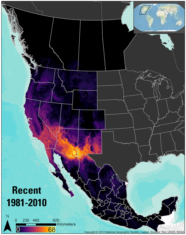
I am an Ecologist at the USGS Forest and Rangeland Ecosystem Science Center.
I work on projects related to restoration ecology in sagebrush ecosystems and reptile distribution modeling across western North America.
Professional Experience
2016 - Present: Ecologist, USGS Forest and Rangeland Ecosystem Science Center, Boise, ID
2013 - 2016: Research Assistant, Department of Biological Sciences, Boise State University, Boise, ID
2012 - 2013: Biological Field Technician, USGS Forest and Rangeland Ecosystem Science Center, Boise, ID
Education and Certifications
M.S., Biology, Boise State University, Boise, ID (2016)
B.S., Biology, Ecology, Boise State University, Boise, ID (2013)
Science and Products
If you are unable to access or download a product, email fresc_outreach@usgs.gov a request, including the full citation, or call (541) 750-1030.
Reestablishing a foundational species: limitations on post-wildfire sagebrush seedling establishment
Protecting restoration investments from the cheatgrass-fire cycle in sagebrush steppe
Reptiles under the conservation umbrella of the greater sage‐grouse
Land treatment exploration tool
Wildland Fire Trends Tool
GIS Clipping and Summarization Tool for Points, Lines, Polygons, and Rasters
The Wildfire Trends Tool: A data visualization and analysis tool to meet land management needs and facilitate scientific inquiry
Integrating short-term climate forecast into a restoration management support tool
Land Treatment Exploration Tool
If you are unable to access or download a product, email fresc_outreach@usgs.gov a request, including the full citation, or call (541) 750-1030.
Reestablishing a foundational species: limitations on post-wildfire sagebrush seedling establishment
Combined wildland fire datasets for the United States and certain territories, 1800s-Present
USGS Land Treatment Digital Library Data Release: A centralized archive for land treatment tabular and spatial data (ver. 5.0, July 2022)
NRCS FY2018 Soil Properties and Interpretations, Derived Using gSSURGO Data and Tools
Combined wildfire datasets for the United States and certain territories, 1878-2019
Reptile Richness in the Range of the Sage-grouse, Derived From Species Range Maps
The Sagebrush Biome Range Extent, as Derived from Classified Landsat Imagery
Western United States 30m Raw Heatload Values
Western US Ruggedness Reclassified into 6 Classes
If you are unable to access or download a product, email fresc_outreach@usgs.gov a request, including the full citation.
Amphibian and Reptile Species Distribution Explorer
The Amphibian and Reptile Species Distribution Explorer provides information about herptile distributions and species richness in an easy-to-understand and accessible format for scientists and natural resource managers, interested landowners, citizen scientists, and anyone interested in amphibians and reptiles.
Interactive Supplement - When and How Often do Seedings Experience a Wildfire?
Interactive Tableau supplement to the paper “Protecting Restoration Investments from the Cheatgrass-fire Cycle in Sagebrush Steppe.”
Wildland Fire Trends Tool
The Wildland Fire Trends Tool (WFTT) is a data visualization and analysis tool that calculates and displays wildfire trends and patterns for the western U.S. based on user-defined regions of interest, time periods, and ecosystem types. Users can use the tool to easily generate a variety of maps, graphs, and tabular data products that are informative for all levels of expertise.
Land Treatment Exploration Tool
The Land Treatment Exploration Tool is designed for resource managers to use when planning land treatments. The tool provides useful summaries of environmental characteristics of planned treatment areas and facilitates adaptive management practices by comparing those characteristics to other similar treatments within a specified distance or area of interest. Provisional Software.
Land Treatment Digital Library
The Land Treatment Digital Library (LTDL) was created by the U.S. Geological Survey to catalog legacy land treatment information on Bureau of Land Management lands in the western United States. The LTDL currently houses thousands of treatments from BLM lands across 10 states.
If you are unable to access or download a product, email fresc_outreach@usgs.gov a request, including the full citation, or call (541) 750-1030.
GIS Clipping and Summarization Toolbox
Science and Products
- Publications
If you are unable to access or download a product, email fresc_outreach@usgs.gov a request, including the full citation, or call (541) 750-1030.
Reestablishing a foundational species: limitations on post-wildfire sagebrush seedling establishment
Improving post-wildfire restoration of foundational plant species is crucial for conserving imperiled ecosystems. We sought to better understand the initial establishment of sagebrush (Artemisia sp.), a foundational shrubland species over a vast area of western North America, in the first 1–2 years post-wildfire, a critical time period for population recovery. Field data from 460 sagebrush populatAuthorsRobert Arkle, David Pilliod, Matthew Germino, Michelle Jeffries, Justin L. WeltyProtecting restoration investments from the cheatgrass-fire cycle in sagebrush steppe
The US federal government has recently committed to the difficult task of slowing and managing the invasive grass-fire cycle in sagebrush steppe, where property, livelihoods, and entire ecosystems are at risk. To safely manage this crisis, the government recently proposed to construct about 17,700 km of fuel breaks and millions of hectares of fuel reduction treatments in six western states. A chalAuthorsDavid Pilliod, Michelle Jeffries, Justin L. Welty, Robert ArkleReptiles under the conservation umbrella of the greater sage‐grouse
In conservation paradigms, management actions for umbrella species also benefit co‐occurring species because of overlapping ranges and similar habitat associations. The greater sage‐grouse (Centrocercus urophasianus) is an umbrella species because it occurs across vast sagebrush ecosystems of western North America and is the recipient of extensive habitat conservation and restoration efforts thatAuthorsDavid Pilliod, Michelle Jeffries, Robert Arkle, Deanna H. OlsonLand treatment exploration tool
OverviewLand managers make decisions regarding restoration and rehabilitation actions that influence landscapes and ecosystems. Many of these decisions involve soil and vegetation manipulations, often known as land treatments. Historically, treatments were planned on a case by case basis with decisions derived from personal experience of past successes or failures. Current adaptive management straAuthorsDavid S. Pilliod, Justin L. Welty, Michelle I. Jeffries, Linda S. Schueck, Thomas J. Zarriello - Science
Wildland Fire Trends Tool
The Wildland Fire Trends Tool (WFTT) is a data visualization and analysis tool that calculates and displays wildfire trends and patterns for the western U.S. based on user-defined regions of interest, time periods, and ecosystem types. Users can use the tool to easily generate a variety of maps, graphs, and tabular data products that are informative for all levels of expertise. The WFTT provides...GIS Clipping and Summarization Tool for Points, Lines, Polygons, and Rasters
Geographic Information System (GIS) analyses are an essential part of natural resource management and research. Calculating and summarizing data within intersecting GIS layers is common practice for analysts and researchers. However, the various tools and steps required to complete this process are slow and tedious, requiring many tools iterating over hundreds, or even thousands of datasets. We prThe Wildfire Trends Tool: A data visualization and analysis tool to meet land management needs and facilitate scientific inquiry
Fighting wildfires and reducing their negative effects on natural resources costs billions of dollars annually in the U.S. We will develop the Wildfire Trends Tool (WTT), a data visualization and analysis tool that will calculate and display wildfire trends and patterns for the western U.S. based on user-defined regions of interest, time periods, and ecosystem types. The WTT will be publicly availIntegrating short-term climate forecast into a restoration management support tool
Natural resources managers are regularly required to make decisions regarding upcoming restoration treatments, often based on little more than business as usual practices. To assist in the decision-making process, we created a tool that predicts site-specific soil moisture and climate for the upcoming year, and provides guidance on whether common restoration activities (i.e. seeding, planting) wilLand Treatment Exploration Tool
The Land Treatment Exploration Tool provides a practical resource for managers who are planning restoration and rehabilitation actions on public lands. The tool generates a variety of spatial products while being user friendly for all levels of GIS expertise, even to those with little or no experience. - Data
If you are unable to access or download a product, email fresc_outreach@usgs.gov a request, including the full citation, or call (541) 750-1030.
Reestablishing a foundational species: limitations on post-wildfire sagebrush seedling establishment
This dataset contains observations used to better understand the initial establishment of sagebrush (Artemisia sp.), in the first 1-2 years post-wildfire. Field data come from 460 sagebrush populations sampled across the Great Basin and many GIS-derived co-variates are included as well.Combined wildland fire datasets for the United States and certain territories, 1800s-Present
First, we would like to thank the wildland fire advisory group. Their wisdom and guidance helped us build the dataset as it currently exists. This dataset is comprised of two different zip files. Zip File 1: The data within this zip file are composed of two wildland fire datasets. (1) A merged dataset consisting of 40 different wildfire and prescribed fire layers. The original 40 layers were all fUSGS Land Treatment Digital Library Data Release: A centralized archive for land treatment tabular and spatial data (ver. 5.0, July 2022)
Across the country, public land managers make hundreds of decisions each year that influence landscapes and ecosystems within the lands they manage. Many of these decisions involve vegetation manipulations known as land treatments. Land treatments include activities such as removal or alteration of plant biomass, seeding burned areas, and herbicide applications. Data on these land treatments histoNRCS FY2018 Soil Properties and Interpretations, Derived Using gSSURGO Data and Tools
These data depict the western United States Map Unit areas as defined by the USDA NRCS. Each Map Unit area contains information on a variety of soil properties and interpretations. The raster is to be joined to the .csv file by the field "mukey." We keep the raster and csv separate to preserve the full attribute names in the csv that would be truncated if attached to the raster. Once joined, the rCombined wildfire datasets for the United States and certain territories, 1878-2019
This dataset is comprised of four different zip files. Zip File 1: A combined wildfire polygon dataset ranging in years from 1878-2019 (142 years) that was created by merging and dissolving fire information from 12 different original wildfire datasets to create one of the most comprehensive wildfire datasets available. Attributes describing fires that were reported in the various source data, inclReptile Richness in the Range of the Sage-grouse, Derived From Species Range Maps
These data depict reptile species richness within the range of the Greater Sage-grouse. Species boundaries were defined as the total extent of a species geographic limits. This raster largely used species range data from "U.S. Geological Survey - Gap Analysis Project Species Range Maps CONUS_2001", however in order for a more complete picture of species richness, additional sources were used for sThe Sagebrush Biome Range Extent, as Derived from Classified Landsat Imagery
This feature estimates the geographic extent of the sagebrush biome in the United States. It was created for the Western Association of Fish and Wildlife Agency's (WAFWA) Sagebrush Conservation Strategy publication as a visual for the schematic figures. This layer does not represent the realized distribution of sagebrush and should not be used to summarize statistics about the distribution or precWestern United States 30m Raw Heatload Values
Heat load, a unitless value from approximately 0 (low incident radiation) to around 1 (high incident radiation), is calculated using aspect, slope, and latitude (McCune and Dylan 2002 ). This raster was generated as a precursor layer to generate a layer used with the Land Treatment Planning Tool. The planning tool uses the binned version of this data, while this raster includes the raw, calculatedWestern US Ruggedness Reclassified into 6 Classes
"Vector Ruggedness Measure (VRM) measures terrain ruggedness as the variation in three-dimensional orientation of grid cells within a neighborhood. Vector analysis is used to calculate the dispersion of vectors normal (orthogonal) to grid cells within the specified neighborhood. This method effectively captures variability in slope and aspect into a single measure. Ruggedness values in the output - Multimedia
- Web Tools
If you are unable to access or download a product, email fresc_outreach@usgs.gov a request, including the full citation.
Amphibian and Reptile Species Distribution Explorer
The Amphibian and Reptile Species Distribution Explorer provides information about herptile distributions and species richness in an easy-to-understand and accessible format for scientists and natural resource managers, interested landowners, citizen scientists, and anyone interested in amphibians and reptiles.
Interactive Supplement - When and How Often do Seedings Experience a Wildfire?
Interactive Tableau supplement to the paper “Protecting Restoration Investments from the Cheatgrass-fire Cycle in Sagebrush Steppe.”
Wildland Fire Trends Tool
The Wildland Fire Trends Tool (WFTT) is a data visualization and analysis tool that calculates and displays wildfire trends and patterns for the western U.S. based on user-defined regions of interest, time periods, and ecosystem types. Users can use the tool to easily generate a variety of maps, graphs, and tabular data products that are informative for all levels of expertise.
Land Treatment Exploration Tool
The Land Treatment Exploration Tool is designed for resource managers to use when planning land treatments. The tool provides useful summaries of environmental characteristics of planned treatment areas and facilitates adaptive management practices by comparing those characteristics to other similar treatments within a specified distance or area of interest. Provisional Software.
Land Treatment Digital Library
The Land Treatment Digital Library (LTDL) was created by the U.S. Geological Survey to catalog legacy land treatment information on Bureau of Land Management lands in the western United States. The LTDL currently houses thousands of treatments from BLM lands across 10 states.
- Software
If you are unable to access or download a product, email fresc_outreach@usgs.gov a request, including the full citation, or call (541) 750-1030.
GIS Clipping and Summarization Toolbox
This tool is being provided free to the public in support of GIS specialists who calculate summary information. - News