
Volcano Watch — NASA practices for Mars exploration on Kīlauea Volcano
A simulated Mars landing mission unfolded on Kīlauea Volcano for two weeks in September 2016.
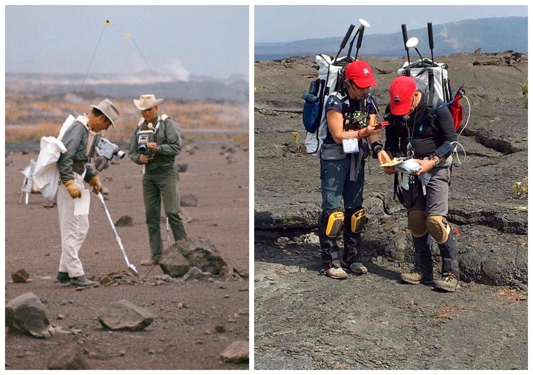
Unknown to thousands of visitors in Hawai‘i Volcanoes National Park, a simulated Mars landing mission unfolded on Kīlauea Volcano for two weeks in September 2016. Sadly, Matt Damon, who starred in the movie "The Martian," was not aboard.
The 2016 work was part of NASA's Biologic Analog Science Associated with Lava Terrains (BASALT) program.
BASALT consists of an international group of scientists, engineers, mission operators, and astronauts dedicated to furthering the human-robotic exploration of our neighboring planet, Mars. One of the main objectives of the BASALT research program is to examine how humans can effectively explore the surface of Mars for life and to understand the geologic history of the Red Planet.
Kīlauea Volcano offers landscapes that are not perfect analogs for Mars, but that come quite close.
Under special permit from Hawai‘i Volcanoes National Park, the BASALT team of 65 scientists, engineers, computer scientists, human-machine engineering experts, and astronauts targeted the Mauna Ulu region on Kīlauea's East Rift Zone as the Mars landing and exploration area.
The BASALT team also set up a Science Mission Control at Kīlauea Military Camp, a facility located in the National Park. Two-way voice, video and data streaming was established between this command center and the field team, which consisted of two crew members who conducted field sampling under simulated Mars mission conditions around Mauna Ulu. These communications were delayed by up to 15 minutes to mimic transmission latencies due to the great distance between Earth and Mars.
In addition to simulating Mars mission conditions, the project also evaluated the use of various mobile science platforms, hand-held devices to determine temperature and composition of rocks, and cutting-edge video and data display technologies.
The USGS Hawaiian Volcano Observatory (HVO) supported the BASALT project by hosting communication relay antennae in our observation tower. Several HVO staff members observed the operation over the course of the project and marveled at the complicated chain of decision-making that guided the astronauts' exploration, sampling, and documentation efforts.
Hawaiian volcanoes have featured prominently in the training of American astronauts for decades. In the 1960s and 1970s, NASA used various locations on Kīlauea and the high slopes of Mauna Kea to teach Apollo astronauts volcanology and prepare them for what they might encounter on the surface of the Moon.
More recently, NASA, along with the University of Hawai‘i and state-sponsored PISCES (Pacific International Space Center for Exploration Systems), has conducted experiments to advance the feasibility of long-term human habitation on Mars.
From 2008 to 2012, international campaigns carried out on Mauna Kea tested methods of extracting oxygen and water from volcanic cinder. Since 2012, the Hawai‘i Space Exploration Analog and Simulation, or HI-SEAS, program has conducted long-duration isolation missions in which crews spend up to a year inside a geodesic dome located at an elevation of 2,500 m (8,200 ft) on the slope of Mauna Loa.
More than a century ago, HVO founder Thomas A. Jaggar enthusiastically promoted the active volcanoes of Hawai‘i as a world-class scientific laboratory. While he may not have imagined Kīlauea as a training ground for future space explorers, he almost certainly would have approved. In fact, we expect he'd argue that the first astronaut to roam the surface of the Red Planet should be a volcanologist trained on the Island of Hawai‘i!
Prior to the BASALT program at Kīlauea Volcano, the NASA team conducted another simulated Mars landing in 2015 at the Craters of the Moon National Monument in Idaho.
The BASALT team hopes to return to Hawai‘i in 2017 to repeat the mission in another area of Kīlauea to further refine their planning for eventual exploration of Mars.
For more information on NASA's BASALT program, please visit: https://spacescience.arc.nasa.gov/basalt/.
Volcano Activity Update
Kīlauea continues to erupt at its summit and East Rift Zone. This past week, the summit lava lake level varied between about 20 and 38 m (66–125 ft) below the vent rim. The 61g flow was still active, with lava entering the ocean near Kamokuna and surface breakouts roughly 5 km (3 mi) from the vent on Pu‘u ‘Ō‘ō and on the coastal plain about 1 km (0.6 mi) inland of the ocean entry, as of Feb. 16. The 61g flows do not pose an immediate threat to nearby communities.
Mauna Loa is not erupting. Rates of deformation and seismicity have not changed significantly in the past week and continue to be above long-term background levels. Only a few small-magnitude earthquakes occurred beneath the volcano, primarily in the upper Southwest Rift and Moku‘āweoweo caldera at depths less than 5 km (3 miles). A few earthquakes also occurred on the west flank of the volcano at depths mostly above 5 km (3 miles). Global Positioning System (GPS) measurements continue to show deformation related to inflation of a magma reservoir beneath the summit and upper Southwest Rift Zone. No significant change in summit fumarole temperature was noted over the past week.
One earthquake was reported felt on the Island of Hawai‘i this past week. On February 13, 2017, at 10:02 p.m., HST, a magnitude-2.5 earthquake occurred 10.0 km (6.2 mi) southwest of Honoka‘a at a depth of 13 km (8 mi).