
Volcano Science Center
Find U.S. Volcano
The Volcano Science Center is the primary center serving the mission of the USGS Volcano Hazards Program — to enhance public safety and minimize social and economic disruption from volcanic unrest and eruption. The center is home to the five US volcano observatories with offices in Anchorage, Alaska; Menlo Park and Mountain View, California; Vancouver, Washington; and Hilo, Hawaii.


News
Volcano Watch — When will Halemaʻumaʻu fill with lava?
Volcano Watch — When will Halemaʻumaʻu fill with lava?
What’s that smell? Tracking Yellowstone’s hydrocarbon history
What’s that smell? Tracking Yellowstone’s hydrocarbon history
Photo & Video Chronology — Kīlauea summit monitoring overflight
Photo & Video Chronology — Kīlauea summit monitoring overflight
Publications
Comprehensive characterization of Mauna Loa basalt rheology based on the 2022 eruption Comprehensive characterization of Mauna Loa basalt rheology based on the 2022 eruption
Rheological data are crucial for the understanding of storage, transport, eruption, and emplacement of magma and lava. While viscosity estimates for lavas from Mauna Loa, the largest active volcano on Earth, exist, no direct rheological measurements have been done to date. This is especially surprising given the role Mauna Loa lavas and resulting landforms play in the interpretation of...
Seeing is believing: Livestream video monitoring of Hawaiian eruptions Seeing is believing: Livestream video monitoring of Hawaiian eruptions
Livestream video has become a crucial tool for volcano monitoring in recent years, building upon the use of webcam snapshots that have been common for the past two decades. In Hawaii, livestream video was first tested in 2018, and today, livestream video is a vital tool for the Hawaiian Volcano Observatory and partner agencies (National Park Service and Hawaiʻi County Civil Defense) as...
Timescales of cumulate mobilization and mixing for the 1868 A.D. eruption of Mauna Loa, Island of Hawai‘i Timescales of cumulate mobilization and mixing for the 1868 A.D. eruption of Mauna Loa, Island of Hawai‘i
The deadly 1868 A.D. eruption of Mauna Loa’s lower Southwest Rift Zone (Island of Hawai‘i) included a M7.9 earthquake and associated tsunami and landslides, demonstrating the severe hazards posed by Earth’s largest active subaerial volcano. To better understand the relationship between intense seismic activity, dike emplacement, magma storage, transport histories, and mobilization of...
Science
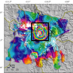
Uplift along the north rim of Yellowstone Caldera
An area on the north rim of Yellowstone caldera, to the south of Norris Geyser Basin, started to uplift slightly in July 2025. Similar deformation occurred in the same area during 1996-2004 and reveals characteristics of the subsurface.
USGS volcano-hydrothermal fluid chemistry data
The USGS has published chemistry data for volcanic and hydrothermal fluids sampled at sites around the United States.

How are lava flows mapped in Hawaii?
Lava flow mapping provides situational awareness of volcanic eruptive hazards in Hawaii. During eruptions, USGS Hawaiian Volcano Observatory (HVO) scientists employ a variety of techniques to collect and disseminate map data depicting key eruptive features, especially lava flows.