
250K OnDemand Topo Cartographic Specifications - Structures
250K OnDemand Topo cartographic specifications including feature symbology and labels for Structures including public services.
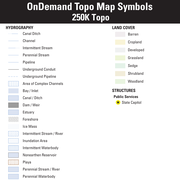
Structures Feature Types
Table of Contents
Public Service
PUBLIC SERVICE
State Capitol
Subtype of Public Service
- FType: Government and Military
- FCode: 83006
- Feature Description: A building occupied by a state legislature.
- Feature Geometry: Point
Graphic Depiction
Media

Sources/Usage: Public Domain. View Media Details
- Point Graphic Depiction:
- Symbol: State Capitol
- Symbol Description: Dark gray star within a yellow circle.
- Linear Graphic Depiction: Not applicable
- Polygon Graphic Depiction: Not applicable
Point Symbology Specifications
- Layer 1 (Shape Marker: Esri Default 94):
- Size: 10.50 pt
- Color (R,G,B): 28,28,28
- Transparency: 0%
- Layer 2 (Shape Marker: Esri Default 33)
- Size: 12.00 pt
- Color (R,G,B): 255,255,0
- Transparency: 0%
Labeling
Media

Sources/Usage: Public Domain. View Media Details
- Labeling Graphic Depiction:
- Label: State Capitol - Label
- Label Description: Gray text with a yellow halo.
- Font Style: Segoe UI
- Font Size: 6.50 pt
- Font Color (R,G,B): 52,52,52
- Font Halo Size: 0.50 pt
- Font Halo Color (R,G,B): 255,255,173
- Placement Properties: Best position around point
US Capitol
Subtype of Public Service
- FType: Government and Military
- FCode: 83004
- Feature Description: A building occupied by a national legislature.
- Feature Geometry: Point
Graphic Depiction
Media
Sources/Usage: Public Domain. View Media Details
- Point Graphic Depiction:
- Symbol: US Capitol
- Symbol Description: Dark gray star within a yellow circle.
- Linear Graphic Depiction: Not applicable
- Polygon Graphic Depiction: Not applicable
Point Symbology Specifications
- Layer 1 (Shape Marker: Esri Default 94):
- Size: 10.50 pt
- Color (R,G,B): 28,28,28
- Transparency: 0%
- Layer 2 (Shape Marker: Esri Default 33)
- Size: 12.00 pt
- Color (R,G,B): 255,255,0
- Transparency: 0%
Labeling
Media
Sources/Usage: Public Domain. View Media Details
- Labeling Graphic Depiction:
- Label: US Capitol - Label
- Label Description: Gray text with a yellow halo.
- Font Style: Segoe UI
- Font Size: 6.50 pt
- Font Color (R,G,B): 52,52,52
- Font Halo Size: 0.50 pt
- Font Halo Color (R,G,B): 255,255,173
- Placement Properties: Best position around point
Related Information
Related Information
-
250K OnDemand Topo Cartographic Specifications - Map Symbol Guide 250K OnDemand Topo Cartographic Specifications - Map Symbol Guide
250K OnDemand Topo cartographic specifications Map Symbol Guide.
250K OnDemand Topo Cartographic Specifications 250K OnDemand Topo Cartographic Specifications
This page and associated links define the U.S. Geological Survey (USGS) 250K OnDemand Topo cartographic specifications including feature symbology and labels. The specifications are organized by data sets and themes listed within.
250K OnDemand Topo Cartographic Specifications - Version History 250K OnDemand Topo Cartographic Specifications - Version History
This page highlights version history and details the refinements made to the published 250K Topo Cartographic Specifications.
250K OnDemand Topo Cartographic Specifications - Elevation 250K OnDemand Topo Cartographic Specifications - Elevation
250K OnDemand Topo cartographic specifications including feature symbology and labels for elevation generated contours and shaded relief.
250K OnDemand Topo Cartographic Specifications - Geographic Names 250K OnDemand Topo Cartographic Specifications - Geographic Names
250K OnDemand Topo cartographic specifications including feature symbology and labels for Natural Features, Landforms, and Populated Places.
250K OnDemand Topo Cartographic Specifications - Government Units 250K OnDemand Topo Cartographic Specifications - Government Units
250K OnDemand Topo cartographic specifications including feature symbology and labels for Government Units including Counties or Equivalent, Designated Areas, Federally Managed Lands (Bureau of Land Management, Forest Service, Fish and Wildlife Service, and National Park Service), International, Military, National Cemetery, and State Boundaries.
250K OnDemand Topo Cartographic Specifications - Hydrography 250K OnDemand Topo Cartographic Specifications - Hydrography
250K OnDemand Topo cartographic specifications including feature symbology and labels for Hydrography NHDArea, NHDFlowline, and NHDWaterbody.
250K OnDemand Topo Cartographic Specifications - Land Cover 250K OnDemand Topo Cartographic Specifications - Land Cover
250K OnDemand Topo cartographic specifications including feature symbology and labels for Land Cover including barren, croplands, developed, grasslands, sedge, shrublands, and woodlands.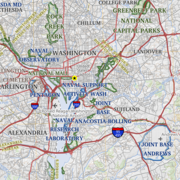
250K OnDemand Topo Cartographic Specifications - Structures 250K OnDemand Topo Cartographic Specifications - Structures
250K OnDemand Topo cartographic specifications including feature symbology and labels for Structures including public services.
250K OnDemand Topo Cartographic Specifications - Transportation 250K OnDemand Topo Cartographic Specifications - Transportation
250K OnDemand Topo cartographic specifications including feature symbology and labels for Transportation including Airports, Roads, and Road Shields.