
250K OnDemand Topo Cartographic Specifications - Transportation
250K OnDemand Topo cartographic specifications including feature symbology and labels for Transportation including Airports, Roads, and Road Shields.
Transportation Feature Types
Table of Contents
Airport
- Airport (Visibility Filter: Pop 250,000–499,999)
- Airport (Visibility Filter: Pop 500,000–999,999)
- Airport (Visibility Filter: Pop 1+ Million)
Roads
Road Shields
AIRPORT
Airport (Visibility Filter: Pop 250,000–499,999)
Subtype of Airport
- FType: 200
- FCode: 20000
- Feature Description: An area of land or a structure used or intended to be used for the landing and takeoff of airplanes, and includes its building and facilities, if any.
- Feature Geometry: Point
Graphic Depiction
Media

Sources/Usage: Public Domain. View Media Details
- Point Graphic Depiction:
- Symbol: Airport (Visibility Filter: Pop 250,000–499,999)
- Symbol Description: Gray airplane symbol.
- Linear Graphic Depiction: Not applicable
- Polygon Graphic Depiction: Not applicable
Point Symbology Specifications
- Layer 1 (Shape Marker: Esri Default 111) (Rotation: 90-Degree Angle)
- Size: 10.00 pt
- Color (R,G,B): 51,51,51
- Transparency: 0%
- Layer 2 (Halo)
- Size: 0.50 pt
- Color (R,G,B): 245,245,245
- Transparency: 0%
Labeling
Media

Sources/Usage: Public Domain. View Media Details
- Labeling Graphic Depiction:
- Label: Airport (Visibility Filter: Pop 250,000–499,999) – Label
- Label Description: Gray text displaying official airport name.
- Font Style: Segoe UI
- Font Size: 7.00 pt
- Font Color (R,G,B): 78,78,78
- Font Halo Size: 0.50 pt
- Font Halo Color (R,G,B): 250,250,250
- Placement Properties: Best position around point
Airport (Visibility Filter: Pop 500,000–999,999)
Subtype of Airport
- FType: 200
- FCode: 20000
- Feature Description: An area of land or a structure used or intended to be used for the landing and takeoff of airplanes, and includes its building and facilities, if any.
- Feature Geometry: Point
Graphic Depiction
Media
Sources/Usage: Public Domain. View Media Details
- Point Graphic Depiction:
- Symbol: Airport (Visibility Filter: Pop 500,000–999,999)
- Symbol Description: Gray airplane symbol.
- Linear Graphic Depiction: Not applicable
- Polygon Graphic Depiction: Not applicable
Point Symbology Specifications
- Layer 1 (Shape Marker: Esri Default 111) (Rotation: 90-Degree Angle)
- Size: 11.00 pt
- Color (R,G,B): 51,51,51
- Transparency: 0%
- Layer 2 (Halo)
- Size: 0.50 pt
- Color (R,G,B): 245,245,245
- Transparency: 0%
Labeling
Media
Sources/Usage: Public Domain. View Media Details
- Labeling Graphic Depiction:
- Label: Airport (Visibility Filter: Pop 500,000–999,999) – Label
- Label Description: Gray text displaying official airport name.
- Font Style: Segoe UI
- Font Size: 7.00 pt
- Font Color (R,G,B): 78,78,78
- Font Halo Size: 0.50 pt
- Font Halo Color (R,G,B): 250,250,250
- Placement Properties: Best position around point
Airport (Visibility Filter: Pop 1+ Million)
Subtype of Airport
- FType: 200
- FCode: 20000
- Feature Description: An area of land or a structure used or intended to be used for the landing and takeoff of airplanes, and includes its building and facilities, if any.
- Feature Geometry: Point
Graphic Depiction
Media
Sources/Usage: Public Domain. View Media Details
- Point Graphic Depiction:
- Symbol: Airport (Visibility Filter: Pop 1+ Million)
- Symbol Description: Gray airplane symbol.
- Linear Graphic Depiction: Not applicable
- Polygon Graphic Depiction: Not applicable
Point Symbology Specifications
- Layer 1 (Shape Marker: Esri Default 111) (Rotation: 90-Degree Angle)
- Size: 12.00 pt
- Color (R,G,B): 51,51,51
- Transparency: 0%
- Layer 2 (Halo)
- Size: 0.50 pt
- Color (R,G,B): 245,245,245
- Transparency: 0%
Labeling
Media
Sources/Usage: Public Domain. View Media Details
- Labeling Graphic Depiction:
- Label: Airport (Visibility Filter: Pop 1+ Million) – Label
- Label Description: Gray text displaying official airport name.
- Font Style: Segoe UI
- Font Size: 7.00 pt
- Font Color (R,G,B): 78,78,78
- Font Halo Size: 0.50 pt
- Font Halo Color (R,G,B): 250,250,250
- Placement Properties: Best position around point
ROADS
Expressway
Subtype of Roads
- FType: Not applicable
- FCode: Not applicable
- Feature Description: Interstates and limited access highways.
- Feature Geometry: Line
Graphic Depiction
Media

Sources/Usage: Public Domain. View Media Details
- Point Graphic Depiction: Not applicable
- Linear Graphic Depiction:
- Symbol: Expressway
- Symbol Description: Dark red line with maroon casing.
- Polygon Graphic Depiction: Not applicable
Line Symbology Specifications
- Layer 1 (Solid Stroke)
- Size: 1.25 pt
- Color (R,G,B): 175,75,76
- Transparency: 0%
- Layer 2 (Solid Stroke)
- Size: 1.75 pt
- Color (R,G,B): 130,41,41
- Transparency: 0%
Labeling
Media

Sources/Usage: Public Domain. View Media Details
- Labeling Graphic Depiction:
- Label: Expressway – Label
- Label Description: Dark gray text displaying official road name.
- Font Style: Segoe UI, Small Caps
- Font Size: 7.00 pt
- Font Color (R,G,B): 52,52,52
- Font Halo Size: 0.50 pt
- Font Halo Color (R,G,B): 250,250,250
- Placement Properties: Street placement
Secondary Highway
Subtype of Roads
- FType: Not applicable
- FCode: Not applicable
- Feature Description: Main arteries and highways that are not limited access, usually in the U.S. Highway or State Highway systems.
- Feature Geometry: Line
Graphic Depiction
Media

Sources/Usage: Public Domain. View Media Details
- Point Graphic Depiction: Not applicable
- Linear Graphic Depiction:
- Symbol: Secondary Highway
- Symbol Description: Red line with a dark red casing.
- Polygon Graphic Depiction: Not applicable
Line Symbology Specifications
- Layer 1 (Solid Stroke)
- Size: 1.00 pt
- Color (R,G,B): 201,103,103
- Transparency: 0%
- Layer 2 (Solid Stroke)
- Size: 1.50 pt
- Color (R,G,B): 175,75,76
- Transparency: 0%
Labeling
Media
Sources/Usage: Public Domain. View Media Details
- Labeling Graphic Depiction:
- Label: Secondary Highway – Label
- Label Description: Dark gray text displaying official road name.
- Font Style: Segoe UI, Small Caps
- Font Size: 7.00 pt
- Font Color (R,G,B): 52,52,52
- Font Halo Size: 0.50 pt
- Font Halo Color (R,G,B): 250,250,250
- Placement Properties: Street placement
Highway Tunnel
Subtype of Roads
- FType: Not applicable
- FCode: Not applicable
- Feature Description: An underground passage that is open at both ends and contains a road. Connects and maintains transportation flow underneath physical or human-built obstructions, such as a mountains or rivers. Spatial representation is generalized and may not accurately depict the real world location of the feature.
- Feature Geometry: Line
Graphic Depiction
Media

Sources/Usage: Public Domain. View Media Details
- Point Graphic Depiction: Not applicable
- Linear Graphic Depiction:
- Symbol: Highway Tunnel
- Symbol Description: Light pink dashed line with a solid red background line.
- Polygon Graphic Depiction: Not applicable
Line Symbology Specifications
- Layer 1 (Stroke – Dash 3 2)
- Size: 1.05 pt
- Color (R,G,B): 250,227,227
- Transparency: 0%
- Layer 2 (Solid Stroke)
- Size: 1.75 pt
- Color (R,G,B): 201,103,103
- Transparency: 0%
Labeling
Media

Sources/Usage: Public Domain. View Media Details
- Labeling Graphic Depiction:
- Label: Highway Tunnel – Label
- Label Description: Dark gray text displaying official road name.
- Font Style: Segoe UI, Small Caps
- Font Size: 7.00 pt
- Font Color (R,G,B): 52,52,52
- Font Halo Size: 0.50 pt
- Font Halo Color (R,G,B): 250,250,250
- Placement Properties: Street placement
Ramp
Subtype of Roads
- FType: Not applicable
- FCode: Not applicable
- Feature Description: A road, sometimes called a “slip road”, that typically allows controlled access from adjacent, not at-grade roads onto a limited access highway, often in the form of a cloverleaf interchange.
- Feature Geometry: Line
Graphic Depiction
Media

Sources/Usage: Public Domain. View Media Details
- Point Graphic Depiction: Not applicable
- Linear Graphic Depiction:
- Symbol: Ramp
- Symbol Description: Pink line.
- Polygon Graphic Depiction: Not applicable
Line Symbology Specifications
- Layer 1 (Solid Stroke)
- Size: 0.75 pt
- Color (R,G,B): 201,103,103
- Transparency: 0%
Labeling
- Labeling: Not applicable
Local Connector
Subtype of Roads
- FType: Not applicable
- FCode: Not applicable
- Feature Description: Roads that collect traffic from local roads and connect smaller towns, subdivisions, and neighborhoods.
- Feature Geometry: Line
Graphic Depiction
Media

Sources/Usage: Public Domain. View Media Details
- Point Graphic Depiction: Not applicable
- Linear Graphic Depiction:
- Symbol: Local Connector
- Symbol Description: Gray line with a white casing.
- Polygon Graphic Depiction: Not applicable
Line Symbology Specifications
- Layer 1 (Solid Stroke)
- Size: 0.80 pt
- Color (R,G,B): 130,130,130
- Transparency: 0%
- Layer 2 (Solid Stroke)
- Size: 1.50 pt
- Color (R,G,B): 245,245,245
- Transparency: 0%
Labeling
Media

Sources/Usage: Public Domain. View Media Details
- Labeling Graphic Depiction:
- Label: Local Connector – Label
- Label Description: Dark gray text displaying official road name.
- Font Style: Segoe UI, Small Caps
- Font Size: 7.00 pt
- Font Color (R,G,B): 52,52,52
- Font Halo Size: 0.50 pt
- Font Halo Color (R,G,B): 250,250,250
- Placement Properties: Street placement
Local Connector Tunnel
Subtype of Roads
- FType: Not applicable
- FCode: Not applicable
- Feature Description: An underground passage that is open at both ends and contains a road. Connects and maintains transportation flow underneath physical or human-built obstructions, such as a mountains or rivers. Spatial representation is generalized and may not accurately depict the real world location of the feature.
- Feature Geometry: Line
Graphic Depiction
Media

Sources/Usage: Public Domain. View Media Details
- Point Graphic Depiction: Not applicable
- Linear Graphic Depiction:
- Symbol: Local Connector Tunnel
- Symbol Description: Gray dashed line with a solid white background line.
- Polygon Graphic Depiction: Not applicable
Line Symbology Specifications
- Layer 1 (Stroke – Dash 3 2)
- Size: 0.80 pt
- Color (R,G,B): 130,130,130
- Transparency: 0%
- Layer 2 (Solid Stroke)
- Size: 1.50 pt
- Color (R,G,B): 245,245,245
- Transparency: 0%
Labeling
Media

Sources/Usage: Public Domain. View Media Details
- Labeling Graphic Depiction:
- Label: Local Connector Tunnel – Label
- Label Description: Dark gray text displaying official road name.
- Font Style: Segoe UI, Small Caps
- Font Size: 7.00 pt
- Font Color (R,G,B): 52,52,52
- Font Halo Size: 0.50 pt
- Font Halo Color (R,G,B): 250,250,250
- Placement Properties: Street placement
Ferry
Subtype of Roads
- FType: Not applicable
- FCode: Not applicable
- Feature Description: A route that connects and maintains transportation flow over a body of water. Conveys vehicles, people, and cargo over a waterbody in a boat. Excludes commuter ferry (ferry taxis) routes and routes used by sightseeing watercraft. Spatial representation is generalized and may not accurately depict the real world location of the feature.
- Feature Geometry: Line
Graphic Depiction
Media

Sources/Usage: Public Domain. View Media Details
- Point Graphic Depiction: Not applicable
- Linear Graphic Depiction:
- Symbol: Ferry
- Symbol Description: Gray dashed line.
- Polygon Graphic Depiction: Not applicable
Line Symbology Specifications
- Layer 1 (Stroke – Dash 4 2)
- Size: 0.60 pt
- Color (R,G,B): 155,155,155
- Transparency: 0%
Labeling
Media

Sources/Usage: Public Domain. View Media Details
- Labeling Graphic Depiction:
- Label: Ferry – Label
- Label Description: Gray text displaying official ferry route name.
- Font Style: Segoe UI, Small Caps
- Font Size: 7.00 pt
- Font Color (R,G,B): 78,78,78
- Font Halo Size: 0.50 pt
- Font Halo Color (R,G,B): 250,250,250
- Placement Properties: Street placement
ROAD SHIELDS
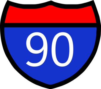
Interstate Route
Subtype of Road Shields
- FType: Not applicable
- FCode: Not applicable
- Feature Description: Fast, wide roads that traverse states and connect important cities. Part of the Interstate Highway System.
- Feature Geometry: Point
Graphic Depiction
Media
Sources/Usage: Public Domain. View Media Details
- Point Graphic Depiction:
- Symbol: Interstate Route
- Symbol Description: Interstate shield shown in the traditional red and blue coloring with a white number identifying the road segment.
- Linear Graphic Depiction: Not applicable
- Polygon Graphic Depiction: Not applicable
Point Symbology Specifications
- Layer 1 (Shape Marker: Esri Default 166)
- Size: 24.00 pt
- Color (R,G,B): 0,0,0
- Transparency: 0%
- Layer 2 (Shape Marker: Esri Default 168)
- Size: 24.00 pt
- Color (R,G,B): 20,51,204
- Transparency: 0%
- Layer 3 (Shape Marker: Esri Default 167)
- Size: 24.00 pt
- Color (R,G,B): 255,0,0
- Transparency: 0%
Labeling
Media
Sources/Usage: Public Domain. View Media Details
- Labeling Graphic Depiction:
- Label: Interstate Route – Label
- Label Description: Interstate shield shown in the traditional red and blue coloring with a white number identifying the road segment.
- Font Style: Segoe UI
- Font Size: 6.00 pt
- Font Color (R,G,B): 255,255,255
- Font Halo Size: Not applicable
- Font Halo Color (R,G,B): Not applicable
- Placement Properties: Regular placement; Centered horizontal on line
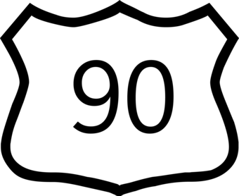
U.S. Route
Subtype of Road Shields
- FType: Not applicable
- FCode: Not applicable
- Feature Description: Also known as “U.S. Highways,” these are numbered highways that connect populated places across the country and can sometimes be limited-access via onramps and offramps.
- Feature Geometry: Point
Graphic Depiction
Media
Sources/Usage: Public Domain. View Media Details
- Point Graphic Depiction:
- Symbol: U.S. Route
- Symbol Description: U.S. Highway road shield with a white fill and black outline and black number identifying the road segment.
- Linear Graphic Depiction: Not applicable
- Polygon Graphic Depiction: Not applicable
Point Symbology Specifications
- Layer 1 (Shape Marker: Esri Default 164)
- Size: 22.00 pt
- Color (R,G,B): 0,0,0
- Transparency: 0%
- Layer 2 (Shape Marker: Esri Default 163)
- Size: 22.00 pt
- Color (R,G,B): 255,255,255
- Transparency: 0%
Labeling
Media
Sources/Usage: Public Domain. View Media Details
- Labeling Graphic Depiction:
- Label: U.S. Route – Label
- Label Description: U.S. Highway road shield with a white fill and black outline and black number identifying the road segment.
- Font Style: Segoe UI
- Font Size: 6.00 pt
- Font Color (R,G,B): 0,0,0
- Font Halo Size: Not applicable
- Font Halo Color (R,G,B): Not applicable
- Placement Properties: Regular placement; Centered horizontal on line
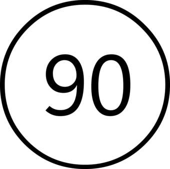
State Route
Subtype of Road Shields
- FType: Not applicable
- FCode: Not applicable
- Feature Description: Numbered routes designated and maintained by local state governments.
- Feature Geometry: Point
Graphic Depiction
Media
Sources/Usage: Public Domain. View Media Details
- Point Graphic Depiction:
- Symbol: State Route
- Symbol Description: State Highway symbol with a rounded white fill, black outline and black number identifying the road segment.
- Linear Graphic Depiction: Not applicable
- Polygon Graphic Depiction: Not applicable
Point Symbology Specifications
- Layer 1 (Shape Marker: Esri Default 171)
- Size: 22.00 pt
- Color (R,G,B): 0,0,0
- Transparency: 0%
- Layer 2 (Shape Marker: Esri Default 172)
- Size: 22.00 pt
- Color (R,G,B): 255,255,255
- Transparency: 0%
Labeling
Media
Sources/Usage: Public Domain. View Media Details
- Labeling Graphic Depiction:
- Label: State Route – Label
- Label Description: State Highway symbol with a rounded white fill, black outline and black number identifying the road segment.
- Font Style: Segoe UI
- Font Size: 6.00 pt
- Font Color (R,G,B): 0,0,0
- Font Halo Size: Not applicable
- Font Halo Color (R,G,B): Not applicable
- Placement Properties: Regular placement; Centered horizontal on line
Related Information
Related Information
-
250K OnDemand Topo Cartographic Specifications - Map Symbol Guide 250K OnDemand Topo Cartographic Specifications - Map Symbol Guide
250K OnDemand Topo cartographic specifications Map Symbol Guide.
250K OnDemand Topo Cartographic Specifications 250K OnDemand Topo Cartographic Specifications
This page and associated links define the U.S. Geological Survey (USGS) 250K OnDemand Topo cartographic specifications including feature symbology and labels. The specifications are organized by data sets and themes listed within.
250K OnDemand Topo Cartographic Specifications - Version History 250K OnDemand Topo Cartographic Specifications - Version History
This page highlights version history and details the refinements made to the published 250K Topo Cartographic Specifications.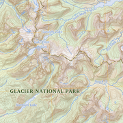
250K OnDemand Topo Cartographic Specifications - Elevation 250K OnDemand Topo Cartographic Specifications - Elevation
250K OnDemand Topo cartographic specifications including feature symbology and labels for elevation generated contours and shaded relief.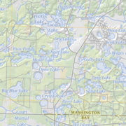
250K OnDemand Topo Cartographic Specifications - Geographic Names 250K OnDemand Topo Cartographic Specifications - Geographic Names
250K OnDemand Topo cartographic specifications including feature symbology and labels for Natural Features, Landforms, and Populated Places.
250K OnDemand Topo Cartographic Specifications - Government Units 250K OnDemand Topo Cartographic Specifications - Government Units
250K OnDemand Topo cartographic specifications including feature symbology and labels for Government Units including Counties or Equivalent, Designated Areas, Federally Managed Lands (Bureau of Land Management, Forest Service, Fish and Wildlife Service, and National Park Service), International, Military, National Cemetery, and State Boundaries.
250K OnDemand Topo Cartographic Specifications - Hydrography 250K OnDemand Topo Cartographic Specifications - Hydrography
250K OnDemand Topo cartographic specifications including feature symbology and labels for Hydrography NHDArea, NHDFlowline, and NHDWaterbody.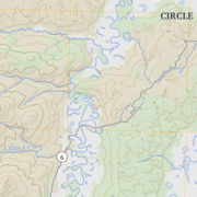
250K OnDemand Topo Cartographic Specifications - Land Cover 250K OnDemand Topo Cartographic Specifications - Land Cover
250K OnDemand Topo cartographic specifications including feature symbology and labels for Land Cover including barren, croplands, developed, grasslands, sedge, shrublands, and woodlands.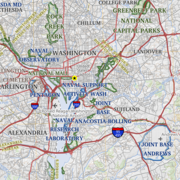
250K OnDemand Topo Cartographic Specifications - Structures 250K OnDemand Topo Cartographic Specifications - Structures
250K OnDemand Topo cartographic specifications including feature symbology and labels for Structures including public services.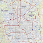
250K OnDemand Topo Cartographic Specifications - Transportation 250K OnDemand Topo Cartographic Specifications - Transportation
250K OnDemand Topo cartographic specifications including feature symbology and labels for Transportation including Airports, Roads, and Road Shields.