
250K OnDemand Topo Cartographic Specifications - Version History
This page highlights version history and details the refinements made to the published 250K Topo Cartographic Specifications.
Click a version number to jump to the associated history notes:
1.0 | 2.0 | 2.01 | 2.02 |
2026:
Version 2.02
Published: 3/30/2026
Summary: Standardized Hydrography feature descriptions.
Hydrography
- Added clarifying statements for hydrography feature descriptions where symbols exist across multiple subtypes as a point, line, and/or polygon.
Version 2.01
Published: 2/17/2026
Summary: Completed conversion of remaining cartographic themes to a bullet-list format including Government Units, Hydrography, Land Cover, Structures, and Transportation.
Government Units (Boundaries)
- Reformatted cartographic specifications to a bullet-list format
Hydrography
- Reformatted cartographic specifications to a bullet-list format
- Corrected spelling and format errors for consistency across pages
Land Cover
- Reformatted cartographic specifications to a bullet-list format
Structures
- Reformatted cartographic specifications to a bullet-list format
Transportation
- Reformatted cartographic specifications to a bullet-list format
Version 2.0
Published: 2/3/2026
Summary: Refinements to Elevation, Geographic Names, Hydrography, Land Cover, and Transportation cartographic specifications and Map Symbol Guide.
Elevation
- Reformatted cartographic specifications to a bullet-list format
Geographic Names
- Reformatted cartographic specifications to a bullet-list format
Hydrography
Removal of NHDLine features including:
- Flume
- Levee
- Nonearthen Shore
- Waterfall
- Tunnel
- Reef
Refinements to NHDArea cartographic specifications including:
- Inundation Area
- Tailings Pond
- Wash
Land Cover
Addition of Land Cover class including:
- Developed
Transportation
Removal of Road features including:
- Local Road
- Local Road Tunnel
- 4WD
Map Symbol Guide
- Version 3.0 released
- Updated symbols for Inundation Area, Tailings Pond and Wash features
- Removal of Flume, Levee, Nonearthen Shore, Waterfall, Tunnel, Reef, Local Road, Local Road Tunnel and 4WD
Version History
- New Version History tracking page publicly released for 250K Topo
Data Sources
- The Protected Areas Database of the United States (PAD-US) is now being used as the official source of federal lands shown in OnDemand Topo products.
2025:
Version 1.0
Published: 9/30/2025
Summary: Complete set of cartographic specifications for Elevation, Geographic Names, Government Units (Boundaries), Hydrography, Land Cover, Structures, and Transportation published on 9/30/2025 concurrent with product release in topoBuilder, including a Map Symbol Guide.
Related Information
Related Information
-
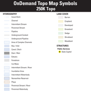
250K OnDemand Topo Cartographic Specifications - Map Symbol Guide 250K OnDemand Topo Cartographic Specifications - Map Symbol Guide
250K OnDemand Topo cartographic specifications Map Symbol Guide.
250K OnDemand Topo Cartographic Specifications 250K OnDemand Topo Cartographic Specifications
This page and associated links define the U.S. Geological Survey (USGS) 250K OnDemand Topo cartographic specifications including feature symbology and labels. The specifications are organized by data sets and themes listed within.
250K OnDemand Topo Cartographic Specifications - Version History 250K OnDemand Topo Cartographic Specifications - Version History
This page highlights version history and details the refinements made to the published 250K Topo Cartographic Specifications.
250K OnDemand Topo Cartographic Specifications - Elevation 250K OnDemand Topo Cartographic Specifications - Elevation
250K OnDemand Topo cartographic specifications including feature symbology and labels for elevation generated contours and shaded relief.
250K OnDemand Topo Cartographic Specifications - Geographic Names 250K OnDemand Topo Cartographic Specifications - Geographic Names
250K OnDemand Topo cartographic specifications including feature symbology and labels for Natural Features, Landforms, and Populated Places.
250K OnDemand Topo Cartographic Specifications - Government Units 250K OnDemand Topo Cartographic Specifications - Government Units
250K OnDemand Topo cartographic specifications including feature symbology and labels for Government Units including Counties or Equivalent, Designated Areas, Federally Managed Lands (Bureau of Land Management, Forest Service, Fish and Wildlife Service, and National Park Service), International, Military, National Cemetery, and State Boundaries.
250K OnDemand Topo Cartographic Specifications - Hydrography 250K OnDemand Topo Cartographic Specifications - Hydrography
250K OnDemand Topo cartographic specifications including feature symbology and labels for Hydrography NHDArea, NHDFlowline, and NHDWaterbody.
250K OnDemand Topo Cartographic Specifications - Land Cover 250K OnDemand Topo Cartographic Specifications - Land Cover
250K OnDemand Topo cartographic specifications including feature symbology and labels for Land Cover including barren, croplands, developed, grasslands, sedge, shrublands, and woodlands.
250K OnDemand Topo Cartographic Specifications - Structures 250K OnDemand Topo Cartographic Specifications - Structures
250K OnDemand Topo cartographic specifications including feature symbology and labels for Structures including public services.
250K OnDemand Topo Cartographic Specifications - Transportation 250K OnDemand Topo Cartographic Specifications - Transportation
250K OnDemand Topo cartographic specifications including feature symbology and labels for Transportation including Airports, Roads, and Road Shields.