
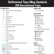
25K Recreational OnDemand Topo Cartographic Specifications - Structures
25K Recreational OnDemand Topo cartographic specifications including feature symbology and labels for Structures including emergency services, medical services, public services, recreation, and shelters.
Structures Feature Types
Table of Contents
Emergency / Medical
Public Service
Recreation
Shelter
EMERGENCY/MEDICAL
Fire Station
Subtype of Emergency / Medical
- FType: Emergency Response and Law Enforcement
- FCode: 74026
- Feature Description: A facility housing fire‑fighting equipment and/or personnel and a provider of emergency medical services.
- Feature Geometry: Point
Graphic Depiction
Media

Sources/Usage: Public Domain. View Media Details
- Point Graphic Depiction:
- Symbol: Fire Station
- Symbol Description: Dark gray shield with flame icon.
- Linear Graphic Depiction: Not applicable
- Polygon Graphic Depiction: Not applicable
Point Symbology Specifications
- Layer 1 (Flame)
- Size: 6.50 pt
- Color (R,G,B): 245,245,245
- Transparency: 0%
- Layer 2 (Shield)
- Size: 12.00 pt
- Color (R,G,B): 35,31,32
- Transparency: 0%
Labeling
- Labeling: Not applicable
Hospital
Subtype of Emergency / Medical
- FType: Health and Medical
- FCode: 80012
- Feature Description: A building or building complex providing inpatient services for medical or surgical care.
- Feature Geometry: Point
Graphic Depiction
Media

Sources/Usage: Public Domain. View Media Details
- Point Graphic Depiction:
- Symbol: Hospital
- Symbol Description: Dark gray shield with cross icon.
- Linear Graphic Depiction: Not applicable
- Polygon Graphic Depiction: Not applicable
Point Symbology Specifications
- Layer 1 (Cross)
- Size: 6.00 pt
- Color (R,G,B): 245,245,245
- Transparency: 0%
- Layer 2 (Shield)
- Size: 12.00 pt
- Color (R,G,B): 35,31,32
- Transparency: 0%
Labeling
- Labeling: Not applicable
Law Enforcement
Subtype of Emergency / Medical
- FType: Emergency Response and Law Enforcement
- FCode: 74034
- Feature Description: A facility housing law enforcement equipment and personnel.
- Feature Geometry: Point
Graphic Depiction
Media

Sources/Usage: Public Domain. View Media Details
- Point Graphic Depiction:
- Symbol: Law Enforcement
- Symbol Description: Dark gray shield with star icon.
- Linear Graphic Depiction: Not applicable
- Polygon Graphic Depiction: Not applicable
Point Symbology Specifications
- Layer 1 (Star)
- Size: 6.00 pt
- Color (R,G,B): 245,245,245
- Transparency: 0%
- Layer 2 (Shield)
- Size: 12.00 pt
- Color (R,G,B): 35,31,32
- Transparency: 0%
Labeling
- Labeling: Not applicable
PUBLIC SERVICE
Capitol
Subtype of Public Service
- FType: Government and Military
- FCode: 83006
- Feature Description: A building occupied by a state legislature.
- Feature Geometry: Point
Graphic Depiction
Media

Sources/Usage: Public Domain. View Media Details
- Point Graphic Depiction:
- Symbol: Capitol
- Symbol Description: Dark gray star.
- Linear Graphic Depiction: Not applicable
- Polygon Graphic Depiction: Not applicable
Point Symbology Specifications
- Layer 1 (Star)
- Size: 12.00 pt
- Color (R,G,B): 35,31,32
- Transparency: 0%
Labeling
- Labeling: Not applicable
US Capitol
Subtype of Public Service
- FType: Government and Military
- FCode: 83004
- Feature Description: A building occupied by a national legislature.
- Feature Geometry: Point
Graphic Depiction
Media
Sources/Usage: Public Domain. View Media Details
- Point Graphic Depiction:
- Symbol: Capitol
- Symbol Description: Dark gray star.
- Linear Graphic Depiction: Not applicable
- Polygon Graphic Depiction: Not applicable
Point Symbology Specifications
- Layer 1 (Star)
- Size: 12.00 pt
- Color (R,G,B): 35,31,32
- Transparency: 0%
Labeling
- Labeling: Not applicable
RECREATION
Cabin
Subtype of Recreation
- FType: Public Attractions and Landmark Building
- FCode: 82007
- Feature Description: A cabin is a small house, cottage or hut, usually of primitive design and often situated in a wild or remote area. Cabins are typically isolated and have some functional significance as a shelter.
- Feature Geometry: Point
Graphic Depiction
Media

Sources/Usage: Public Domain. View Media Details
- Point Graphic Depiction:
- Symbol: Cabin
- Symbol Description: Dark gray symbol depicting log cabin.
- Linear Graphic Depiction: Not applicable
- Polygon Graphic Depiction: Not applicable
Point Symbology Specifications
- Layer 1 (Cabin)
- Size: 12.00 pt
- Color (R,G,B): 35,31,32
- Transparency: 0%
Labeling
- Labeling: Not applicable
Campground
Subtype of Recreation
- FType: Public Attractions and Landmark Building
- FCode: 82008
- Feature Description: A developed, designated site for camping in tents and/or recreational vehicles.
- Feature Geometry: Point
Graphic Depiction
Media

Sources/Usage: Public Domain. View Media Details
- Point Graphic Depiction:
- Symbol: Campground
- Symbol Description: Dark gray symbol depicting camping tent.
- Linear Graphic Depiction: Not applicable
- Polygon Graphic Depiction: Not applicable
Point Symbology Specifications
- Layer 1 (Campground)
- Size: 11.00 pt
- Color (R,G,B): 35,31,32
- Transparency: 0%
Labeling
- Labeling: Not applicable
Headquarters
Subtype of Recreation
- FType: Government and Military
- FCode: 83023
- Feature Description: The primary administrative office of an organization, such as the National Park Service or Forest Service, as designated by the respective organization. This is often a center of operations from which orders are issued.
- Feature Geometry: Point
Graphic Depiction
Media

Sources/Usage: Public Domain. View Media Details
- Point Graphic Depiction:
- Symbol: Headquarters
- Symbol Description: Dark gray symbol depicting a building with a flag.
- Linear Graphic Depiction: Not applicable
- Polygon Graphic Depiction: Not applicable
Point Symbology Specifications
- Layer 1 (Headquarters)
- Size: 12.00 pt
- Color (R,G,B): 35,31,32
- Transparency: 0%
Labeling
- Labeling: Not applicable
Picnic Area
Subtype of Recreation
- FType: Public Attractions and Landmark Building
- FCode: 82040
- Feature Description: An established area for picnics which may include picnic tables and possibly other items related to eating outdoors, such as built‑in grills, water faucets, garbage containers, and restrooms.
- Feature Geometry: Point
Graphic Depiction
Media

Sources/Usage: Public Domain. View Media Details
- Point Graphic Depiction:
- Symbol: Picnic Area
- Symbol Description: Dark gray symbol depicting picnic table.
- Linear Graphic Depiction: Not applicable
- Polygon Graphic Depiction: Not applicable
Point Symbology Specifications
- Layer 1 (Picnic Area)
- Size: 12.00 pt
- Color (R,G,B): 35,31,32
- Transparency: 0%
Labeling
- Labeling: Not applicable
Ranger Station
Subtype of Recreation
- FType: Government and Military
- FCode: 83033
- Feature Description: A ranger station is a small building or a portion of a larger building typically where law enforcement or emergency services are available to visitors, such as where a Park Ranger or Forest Ranger is based.
- Feature Geometry: Point
Graphic Depiction
Media

Sources/Usage: Public Domain. View Media Details
- Point Graphic Depiction:
- Symbol: Ranger Station
- Symbol Description: Dark gray symbol depicting a park ranger standing in front of a building.
- Linear Graphic Depiction: Not applicable
- Polygon Graphic Depiction: Not applicable
Point Symbology Specifications
- Layer 1 (Ranger Station)
- Size: 12.00 pt
- Color (R,G,B): 35,31,32
- Transparency: 0%
Labeling
- Labeling: Not applicable
Trailhead
Subtype of Recreation
- FType: Public Attractions and Landmark Building
- FCode: 82047
- Feature Description: A designated area developed to provide transition from vehicle to foot, horse, or ATV travel. “Designated” means the responsible federal agency has marked the trailhead with ground signage, or it appears on a current and official visitor map, or is included in a GIS dataset provided by the responsible agency.
- Feature Geometry: Point
Graphic Depiction
Media

Sources/Usage: Public Domain. View Media Details
- Point Graphic Depiction:
- Symbol: Trailhead
- Symbol Description: Dark gray symbol depicting hiker.
- Linear Graphic Depiction: Not applicable
- Polygon Graphic Depiction: Not applicable
Point Symbology Specifications
- Layer 1 (Trailhead)
- Size: 12.00 pt
- Color (R,G,B): 35,31,32
- Transparency: 0%
Labeling
- Labeling: Not applicable
Visitor / Information Center
Subtype of Recreation
- FType: Public Attractions and Landmark Building
- FCode: 82048
- Feature Description: A building or building cluster associated with (and usually, but not always, geographically inside) a federal land unit such as a National Park or National Forest. The primary purpose of a visitor center is to serve the general public through direct contact with staff and dissemination of information about the land unit. Visitor centers commonly have educational exhibits, artifact displays, and public restroom facilities. Excludes administrative office buildings open to the public and open‑air structures such as amphitheaters, observation towers, or outdoor interpretive exhibits.
- Feature Geometry: Point
Graphic Depiction
Media

Sources/Usage: Public Domain. View Media Details
- Point Graphic Depiction:
- Symbol: Visitor / Information Center
- Symbol Description: Dark gray lower case “i”.
- Linear Graphic Depiction: Not applicable
- Polygon Graphic Depiction: Not applicable
Point Symbology Specifications
- Layer 1 (Visitor / Information Center)
- Font: Segoe UI (Modified)
- Size: 10.00 pt
- Color (R,G,B): 35,31,32
- Transparency: 0%
Labeling
- Labeling: Not applicable
SHELTER
Shelter
Subtype of Shelter
- FType: Not applicable
- FCode: 82008
- Feature Description: A designated shelter set up to provide warmth and refuge during adverse weather conditions.
- Feature Geometry: Point
Graphic Depiction
Media

Sources/Usage: Public Domain. View Media Details
- Point Graphic Depiction:
- Symbol: Shelter
- Symbol Description: Dark gray symbol depicting a primitive shelter structure.
- Linear Graphic Depiction: Not applicable
- Polygon Graphic Depiction: Not applicable
Point Symbology Specifications
- Layer 1 (Shelter)
- Size: 12.00 pt
- Color (R,G,B): 35,31,32
- Transparency: 0%
Labeling
- Labeling: Not applicable
Related Information
Related Information
-
25K Recreational OnDemand Topo Cartographic Specifications - Map Symbol Guide 25K Recreational OnDemand Topo Cartographic Specifications - Map Symbol Guide
25K Recreational OnDemand Topo cartographic specifications Map Symbol Guide.
25K Recreational OnDemand Topo Cartographic Specifications 25K Recreational OnDemand Topo Cartographic Specifications
This page and associated links define the U.S. Geological Survey (USGS) 25K Recreational OnDemand Topo cartographic specifications including feature symbology and labels. The specifications are organized by data sets and themes listed within.
25K Recreational OnDemand Topo Cartographic Specifications - Version History 25K Recreational OnDemand Topo Cartographic Specifications - Version History
This page highlights version history and details the refinements made to the published 25K Recreational Topo Cartographic Specifications.
25K Recreational OnDemand Topo Cartographic Specifications - Elevation 25K Recreational OnDemand Topo Cartographic Specifications - Elevation
25K Recreational OnDemand Topo cartographic specifications including feature symbology and labels for elevation generated contours and shaded relief.
25K Recreational OnDemand Topo Cartographic Specifications - Geographic Names 25K Recreational OnDemand Topo Cartographic Specifications - Geographic Names
25K Recreational OnDemand Topo cartographic specifications including feature symbology and labels for natural features, landforms, and populated places.
25K Recreational OnDemand Topo Cartographic Specifications - Government Units 25K Recreational OnDemand Topo Cartographic Specifications - Government Units
25K Recreational OnDemand Topo cartographic specifications including feature symbology and labels for Government Units including Counties or equivalent, Designated Areas, Federally Managed Lands (Bureau of Land Management, Forest Service, Grassland, National Monument, National Park, U.S. Fish and Wildlife Service, and Wilderness), International, Military, National Cemetery, and State boundaries.
25K Recreational OnDemand Topo Cartographic Specifications - Hydrography 25K Recreational OnDemand Topo Cartographic Specifications - Hydrography
25K Recreational OnDemand Topo cartographic specifications including feature symbology and labels for Hydrography including NHDArea, NHDFlowline, NHDLine, NHDPoint, NHDWaterbody, and National Wetland Inventory (NWI).
25K Recreational OnDemand Topo Cartographic Specifications - Land Cover 25K Recreational OnDemand Topo Cartographic Specifications - Land Cover
25K Recreational OnDemand Topo cartographic specifications including feature symbology and labels for Land Cover including Woodlands.-
25K Recreational OnDemand Topo Cartographic Specifications - Structures 25K Recreational OnDemand Topo Cartographic Specifications - Structures
25K Recreational OnDemand Topo cartographic specifications including feature symbology and labels for Structures including emergency services, medical services, public services, recreation, and shelters. 
25K Recreational OnDemand Topo Cartographic Specifications - Transportation 25K Recreational OnDemand Topo Cartographic Specifications - Transportation
25K Recreational OnDemand Topo cartographic specifications including feature symbology and labels for Transportation including Airport, National Trails, Standard Trails, Roads, Road Shields, and Forest Service Shields.