
7.5-Minute OnDemand Topo Cartographic Specifications - Version History
This page highlights version history and details the refinements made to the published 7.5-Minute Topo Cartographic Specifications.
Click a version number to jump to the associated history notes:
1.0 | 1.1 | 1.2 | 1.3 |
2026:
Version 1.3
Published: 2/3/2026
Summary: Refinements to map symbology and release of a new Map Symbol Guide.
Map Symbol Guide
- Version 2.3 released - a single-page, modernized symbol guide replacing previous symbol guides
Hydrography
Refinements to map symbology and cartographic specifications
- Foreshore
- Area of Complex Channels
- Ice Mass
Version History
- New Version History tracking page publicly released for 7.5-Minute Topo
Data Sources
- The Protected Areas Database of the United States (PAD-US) is now being used as the official source of federal lands shown in OnDemand Topo products.
2025:
Version 1.2
Published: 5/9/2025
Summary: Reformatted landing page with an image card layout with unique images for each cartographic specification theme.
Layout
- Image card layout redesign with links to each cartographic specification theme
- Added a side bar link to the topoBuilder application
Version 1.1
Published: 2/20/2025
Summary: Replaced all images and supplemented tags for improved display and content discovery for all cartographic specification themes including Elevation, Geographic Names, Government Units (Boundaries), Hydrography, Land Cover, Structures, and Transportation published on 2/20/2025.
Elevation
- Replaced all symbols with higher resolution images for an improved display on all platforms
- Supplemented tags to improve content discovery
- Spelling and general format improvements
Geographic Names
- Replaced all symbols with higher resolution images for an improved display on all platforms
- Supplemented tags to improve content discovery
- Spelling and general format improvements
Government Units (Boundaries)
- Replaced all symbols with higher resolution images for an improved display on all platforms
- Supplemented tags to improve content discovery
- Spelling and general format improvements
Hydrography
- Replaced all symbols with higher resolution images for an improved display on all platforms
- Supplemented tags to improve content discovery
- Spelling and general format improvements
Land Cover
- Replaced all symbols with higher resolution images for an improved display on all platforms
- Supplemented tags to improve content discovery
- Spelling and general format improvements
Structures
- Replaced all symbols with higher resolution images for an improved display on all platforms
- Supplemented tags to improve content discovery
- Spelling and general format improvements
Transportation
- Replaced all symbols with higher resolution images for an improved display on all platforms
- Supplemented tags to improve content discovery
- Spelling and general format improvements
2024:
Version 1.0
Published: 1/4/2024
Summary: Complete set of cartographic specifications for Elevation, Geographic Names, Government Units (Boundaries), Hydrography, Land Cover, Structures, and Transportation published on 1/4/2024.
Related Information
Related Information
-
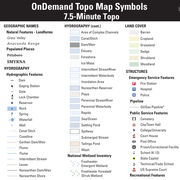
7.5-Minute OnDemand Topo Cartographic Specifications - Map Symbol Guide 7.5-Minute OnDemand Topo Cartographic Specifications - Map Symbol Guide
7.5-Minute OnDemand Topo cartographic specifications map symbol guide.
7.5-Minute OnDemand Topo Cartographic Specifications 7.5-Minute OnDemand Topo Cartographic Specifications
This page and associated links define the U.S. Geological Survey (USGS) 7.5-Minute OnDemand Topo cartographic specifications including feature symbology and labels. The specifications are organized by data sets and themes listed within.
7.5-Minute OnDemand Topo Cartographic Specifications - Elevation 7.5-Minute OnDemand Topo Cartographic Specifications - Elevation
7.5-Minute OnDemand Topo cartographic specifications for elevation generated contours.
7.5-Minute OnDemand Topo Cartographic Specifications - Geographic Names 7.5-Minute OnDemand Topo Cartographic Specifications - Geographic Names
7.5-Minute OnDemand Topo cartographic specifications for Geographic Names including Landforms and Populated Places.
7.5-Minute OnDemand Topo Cartographic Specifications - Government Units 7.5-Minute OnDemand Topo Cartographic Specifications - Government Units
7.5-Minute OnDemand Topo cartographic specifications for Government Units (Boundaries) including Bureau of Land Management, Counties or Equivalent, International, Military, Native American Areas, Public Land Survey System, States, Forest Service, and Wildlife Boundaries.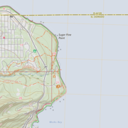
7.5-Minute OnDemand Topo Cartographic Specifications - Hydrography 7.5-Minute OnDemand Topo Cartographic Specifications - Hydrography
7.5-Minute OnDemand Topo cartographic specifications for Hydrography including NHDArea, NHDFlowline, NHDLine, NHDPoint, NHDWaterbody, and National Wetland Inventory (NWI).
7.5-Minute OnDemand Topo Cartographic Specifications - Land Cover 7.5-Minute OnDemand Topo Cartographic Specifications - Land Cover
7.5-Minute OnDemand Topo cartographic specifications for Land Cover including Barren, Cropland, Grassland, Sedge, Shrubland, and Woodland.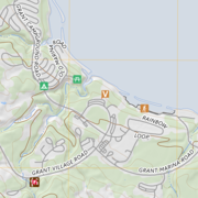
7.5-Minute OnDemand Topo Cartographic Specifications - Structures 7.5-Minute OnDemand Topo Cartographic Specifications - Structures
7.5-Minute OnDemand Topo cartographic specifications for Structures including Emergency Service Features, Pipelines, Public Service Features, and Recreation.
7.5-Minute OnDemand Topo Cartographic Specifications - Transportation 7.5-Minute OnDemand Topo Cartographic Specifications - Transportation
7.5-Minute OnDemand Topo cartographic specifications for Transportation including Airport Features, Rail Features, Route Features, and Trail Features.