
Elevation-Derived Hydrography Data Acquisition Specifications: Metadata Requirements
Elevation-Derived Hydrography Data Acquisition Specifications
Metadata Requirements
Two forms of metadata are required for elevation-derived hydrography deliveries.
Elevation-Derived Hydrography File Geodatabase Metadata
- Metadata for the elevation-derived hydrography file geodatabase shall be provided in Extensible Markup Language (XML) formatted files (Bray and others, 2008) compliant with the Federal Geographic Data Committee Content Standard for Digital Geospatial Metadata (Federal Geographic Data Committee, 1998a). The USGS may offer additional or alternative metadata formats in the future.
- Metadata shall document the following:
- Methods used to delineate features,
- Minimum feature length,
- Format of source elevation data (lidar or IfSAR),
- Source of elevation data (where the data were acquired),
- Date of source elevation data,
- Quality level of source elevation data,
- Ancillary datasets used, including source, date, and resolution,
- Spatial reference system, including horizontal and vertical units, and horizontal and vertical datum used,
- Results of relative accuracy assessment of hydrographic data,
- Method for relative accuracy assessment,
- Field definitions for tables associated with geospatial data (explanation of what type of information the field contains); and
- Contact information for data collector.
Elevation Source Spatial Metadata Requirements
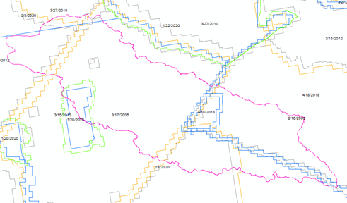
The 3DEP WESM is a USGS-maintained dataset of current lidar data availability and project information, including lidar quality level, data acquisition dates, and links to project-level metadata. Information about the source elevation data shall be stored in the template provided (Table 16). Overlapping portions of the 3DEP polygons shall be excluded based on the methods applied to resolve overlapping elevation source data. See the Source Data Section for guidance on selecting the appropriate overlapping lidar collection (Figure 30). The selected 3DEP WESM polygons provided as spatial metadata shall not include portions of the polygons that were not used in the final mosaicked DEM.
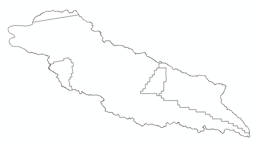
The FDPA shall be used to select and incorporate polygons from the 3DEP Work-Unit Extent Spatial Metadata (U.S. Geological Survey, 2024a) and shall be used as spatial metadata to document the portions of datasets used to create the DEM mosaic for elevation-derived hydrography deliverables (Figure 31). The 3DHP Service should be used when creating the FDPA to avoid including any portion of features from neighboring watersheds (U.S. Geological Survey, 2023).
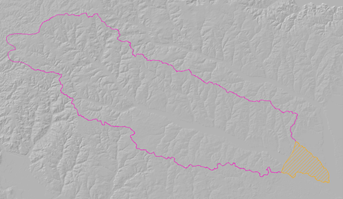
If any portion of the elevation data used to derive the hydrographic data is not from a 3DEP source, provide information about the additional source in the collection report. If any portions of the DEM were found to be unsuitable for deriving hydrography, a polygon shall be drawn around the area and provide an explanation in the attribute table describing the issue (Table 17, Figure 32). See Delineating Features in Areas with DEM Limitations.
The schema name shall include the work unit name of the project for which the DPA was created.