
Elevation-Derived Hydrography READ Rules: Sea/Ocean
The great body of saltwater covering most of the Earth’s surface (Figure 61).

Delineation
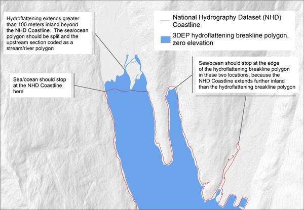
The land/sea interface of a Sea/ocean polygon feature shall match the Sea/ocean hydroflattened breakline polygon created from the source elevation data, except in locations where the hydroflattened breakline polygon is intersected by the NHD coastline feature, in which case, it shall terminate at the NHD coastline location (Figure 62). The basic method for determining the Sea/ocean extent shall include the following:
- Use the hydroflattened polygon collected with the elevation data as the Sea/ocean landward extent or land/sea interface.
- Use the NHD to determine if an NHD coastline feature overlaps the hydroflattened breakline polygon.
- If the hydroflattened breakline polygon extends inland beyond the NHD coastline feature:
- In CONUS, the Sea/ocean polygon shall terminate at the NHD coastline feature.
- In Alaska, the Sea/ocean polygon may terminate up to 100 meters inland beyond the NHD coastline feature.
- If portions of the hydroflattened area are excluded by the NHD coastline feature, they shall be coded as Lake/pond (FCode 39000) or Stream/river (FCode 46000) as appropriate.
- The seaward extent of the Sea/ocean polygon shall be the current WBD boundary.
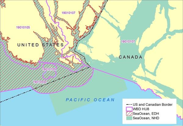
- In international waters, the seaward Sea/ocean polygon extent shall be the international border as defined in by the International Boundaries TIGER/Line Shapefile from the US Census Bureau.
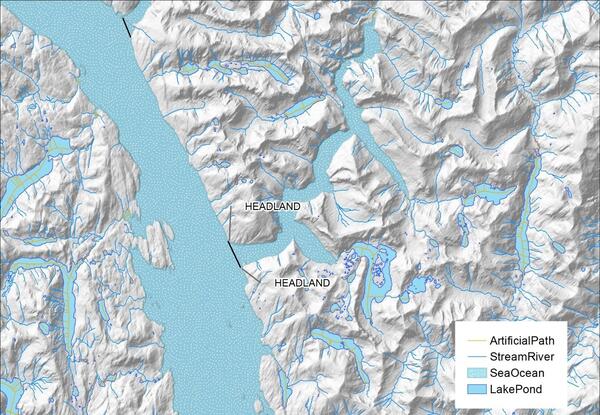
- The Sea/ocean polygon shall be split at major inlets where the distance between headlands is at least a width of 1 nautical mile, which is approximately 2 kilometers (Figure 63).
- Inlets shall be treated as entire features. The primary outlet point downstream of where the inlet reaches 2 kilometers in width shall be used as the split point.
- Space between islands shall not be split where it narrows to 2 kilometers or less. All water between and around islands shall be considered Sea/ocean.
- Sea/ocean polygons shall not contain Artificial path features, nor shall Artificial path features extend into the Sea/ocean polygon from the inland stream network. All inland Artificial path features shall end and snap at the landward edge of the Sea/ocean polygon. All lines and polygons that terminate at the Sea/ocean, shall end and snap at the Sea/ocean polygon boundary.
- The Sea/ocean polygon between the United States and other countries shall be delineated to the international border (Figure 64).
In areas where rivers enter Sea/ocean, the limit is where the conformation of the land and water makes the division obvious, or, if the land and water do not suggest an obvious limit, the limit is where the river reaches a width of 1 nautical mile (approximately 2 kilometers) without further constrictions.
A boundary waterbody is any waterbody that contains the boundary of the collection (meaning the opposite bank or shore is not being mapped). Boundary waterbodies may be a single water surface elevation (for example, lake) or gradient (for example, river). Boundary waterbodies shall contain either a centerline or the extent of the current WBD, depending on the circumstances.
Representation Rules
Delineate features as points, lines, or polygons based on their area or length along different axes (Table 30).
| Kind of feature object | Area | Shortest Axis | Longest Axis |
| 0-dimensional (point) | -- | -- | -- |
| 1-dimensional (line) | -- | -- | -- |
| 2-dimensional (polygon) | greater than 0 | -- | -- |
Special Conditions
None.
Data Extraction
Capture Conditions
If Sea/ocean is within the project area, capture all.
Attribute Information
FClass 1—Hydrography feature defined within the collection criteria of the elevation-derived hydrography specifications.
FCode 44500—Sea/ocean (the great body of saltwater that covers much of the Earth).
EClass 11— Polygon created using a hydroflattening breakline.
OR
FClass 1—Hydrography feature defined within the collection criteria of the elevation-derived hydrography specifications.
FCode 44500—Sea/ocean (the great body of saltwater that covers much of the Earth).
EClass 12— Polygon created from edited hydroflattening breakline on flattened elevation surface.
OR
FClass 1—Hydrography feature defined within the collection criteria of the elevation-derived hydrography specifications.
FCode 44500—Sea/ocean (the great body of saltwater that covers much of the Earth).
EClass 13—Polygon created for non-flattened waterbody features in the DEM.
Source Interpretation Guidelines
The minimum size for islands within Sea/ocean is 1 acre (4,000 square meters).
For examples of islands and intermittently submerged islands, which may be apparent on the elevation surface, see the “Additional Elevation-Derived Hydrography Treatments and Elevation Specific Features” section.