
Alaska Mapping Initiative
IfSAR data available statewide
5-meter resolution elevation grid available for download
Statewide 1:25,000-scale Alaska Topographic Maps
IfSAR Available for Kodiak and Western Aleutian Islands
And St. Lawrence, St. Matthew, St. Paul, and St. George Islands
The Alaska Mapping Initiative supports acquisition of new topographic map data and generation of updated maps for Alaska. These data and maps raise the accuracy of Alaska topographic mapping to levels commonly found in the conterminous United States.
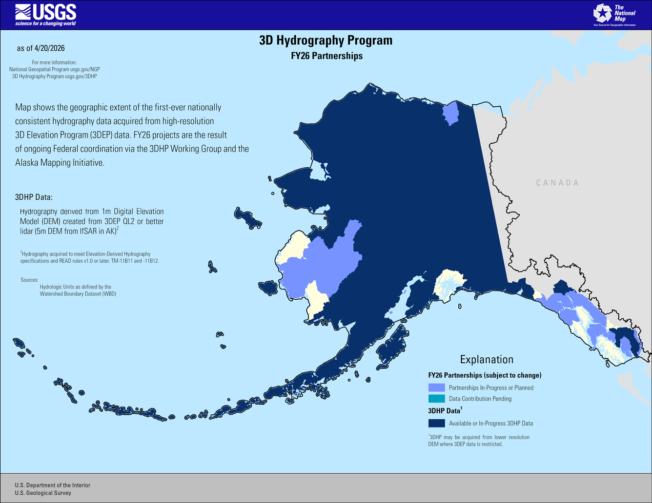
Terrestrial Hydrography Update
USGS and its partners are supporting a statewide update of terrestrial hydrography data (surface water, such as lakes and rivers) for Alaska. 3D Hydrography Program (3DHP) and Watershed Boundary Dataset (WBD) datasets for Alaska are being updated through collaborative Federal and State partnerships to meet accuracy and content specifications suitable for 1:25,000-scale mapping. Hydrographic features and watershed boundaries are being derived from the Alaska IfSAR elevation data using elevation-derived-hydrography methodology. 65% of statewide coverage has been contracted and work is progressing.
High-Resolution Elevation Data Available Statewide for Alaska
In 2011 the Alaska Congressional Delegation requested federal support to modernize Alaska map data. Collection of a 5-meter resolution elevation grid for Alaska began in 2012, replacing the former 60-meter statewide elevation grid. Radar technology called IfSAR (Interferometric Synthetic Aperture Radar) was used to collect the data because it can penetrate the clouds, smoke, and haze often present in Alaska. Statewide airborne IfSAR collection was completed in 2020 and all data are now processed and available for download. The data are free to the public for any use. Alaska IfSAR acquisition supports the broader national 3D Elevation Program.
Downloading Alaska IfSAR Data
Two convenient online portals are available for downloading Alaska IfSAR data. The State of Alaska offers 5-meter IfSAR by tiles for the entire State through their elevation portal found at elevation.alaska.gov. USGS offers the 5-meter IfSAR data tiles, and also provides seamless post-processed elevation data at approximately 10-meter, 30-meter, and 60-meter post spacing. These data can be found at The National Map Downloader. Bulk download instructions are also available.
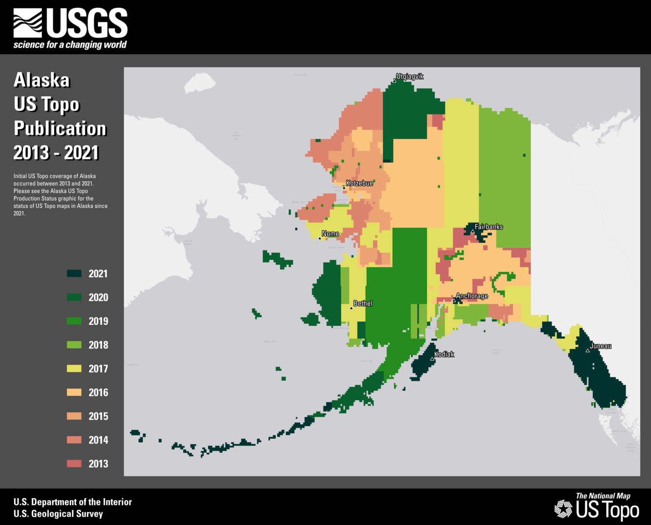
US Topo Maps Available Statewide for Alaska
US Topo is a digital topographic map produced by USGS. 11,278 new US Topo maps of Alaska were published by USGS from 2013 to 2021 and provide statewide map coverage at 1:25,000 map scale. The contours of each map are generated from the IfSAR elevation data. The maps are distributed for free download and use in a convenient PDF format that can be viewed on a computer or mobile device, or printed to paper. A second round of new US Topo map generation began in 2023.
Downloading US Topo Maps
Alaska US Topo maps are available for free download at The National Map Downloader. Paper copies can be purchased from the USGS store.