
Announcing Island of Hawai‘i Volcano Awareness Month Programs in January 2024!
January is Volcano Awareness Month on the Island of Hawai‘i! HVO, in cooperation with Hawai‘i Volcanoes National Park, the University of Hawai‘i at Hilo, and other partners, promotes the importance of understanding and respecting the volcanoes on which we live. Join us at one of the community talks, talk story tables, or guided walks being offered throughout January 2024.
January 2024 is the Island of Hawaiʻi's 15th annual Volcano Awareness Month! Please email askHVO@usgs.gov if you have questions about the programs being offered.
We invite you to the following programs:

Sunday, January 7, 9:30 a.m.
"Birth of Kahuku"
- Guided Hike. Hikes are free and Kahuku Unit entrance is free.
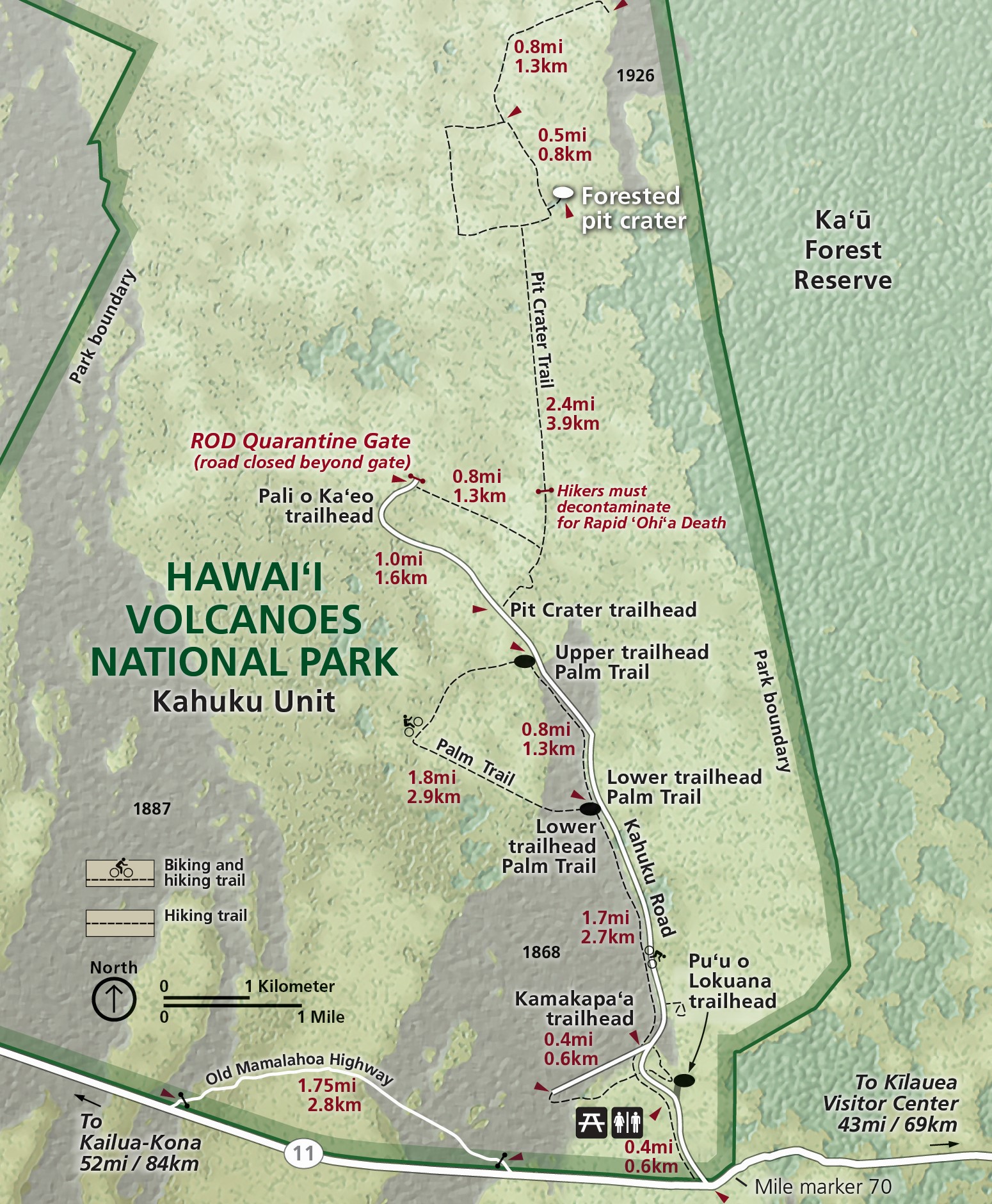
- Start/end location: Meet at the Visitor Contact Station in the Kahuku Unit of Hawaiʻi Volcanoes National Park (Map: https://www.nps.gov/havo/images/HAVO_Kahuku-Map.jpg
- Walk rating: easy, but includes 100-ft (30-m) elevation gain, and crosses rough, uneven lava surfaces
- For your safety: wear comfortable, closed-toe walking shoes; bring protective gear for sun and rain; bring drinking water
Join a National Park Service Ranger on a 1.5-mile walk in the Kahuku Unit of Hawai‘i Volcanoes National Park. Explore the rich geologic history of Kahuku. Traverse the vast 1868 lava flow, see different volcanic formations, including the Southwest Rift Zone of Mauna Loa. Learn about the Kānāwai o Pele, the natural laws of land building that govern Peleʻs realm. Estimated duration is 1.5 hours.

Tuesday, January 9, 7 p.m.
"Kīlauea’s crater-filling summit eruptions"
-
After Dark in the Park Program in Hawai‘i Volcanoes National Park
-
Kīlauea Visitor Center Auditorium, directions: http://www.nps.gov/havo/planyourvisit/directions.htm
- Park entrance fees apply.
Following the dramatic collapses in 2018, the summit of Kīlauea has been in a multi-year phase of crater filling. Five separate eruptions—ranging in duration from about a week to over a year—have filled Halema‘uma‘u crater with lava flows and lava lakes. These eruptions have been accompanied by ever changing geophysical signals recorded by the dense monitoring network. Join USGS Hawaiian Volcano Observatory geologist Matt Patrick as he summarizes the recent activity at Kīlauea summit and highlights its patterns of behavior and Hawaiian Volcano Observatory monitoring techniques.

Wednesday, January 10, 1-4 p.m.
Hawaiian Volcano Observatory Talk Story
- Nāʻālehu Public Library, 95-5669 Mamalahoa Hwy
- Directions: https://www.librarieshawaii.org/branch/naalehu-public-library/
Come talk story with USGS Hawaiian Volcano Observatory chief field engineer Kevan Kamibayashi as he hosts a table from 1:00–4:00 p.m. at the Nāʻālehu Public Library. Do you have questions about recent eruptions in Hawaii, volcanic hazards, how eruptions are monitored, or what it’s like working for a volcano observatory? Kevan, who has worked for the Hawaiian Volcano Observatory for over 25 years, will be available to answer those questions and more. Come talk story, browse resources, and learn more about the volcanoes in your backyard.
Saturday, January 13, 10:00 a.m.
Kīlauea Iki Crater
-
Guided Hike. Hikes are free, but Park entrance fees apply.
- Start/end location: Kīlauea Iki Overlook parking lot on Crater Rim Drive in Hawaiʻi Volcanoes National Park (Map: https://www.nps.gov/havo/planyourvisit/upload/HAVO-Unigrid-Brochure-2019.jpg)
- Hike rating: moderately difficult with an elevation gain of 400 feet (120 m)
- For your safety: wear sturdy, closed-toe walking shoes; bring protective gear for sun and rain; bring drinking water and snacks
The 4-mile (6.2 km) Kīlauea Iki Trail is one of the park’s iconic hiking trails, a popular destination for hikers who cross a steaming crater floor through the intersection of eruption and native rainforest. Delve into the secrets of Kīlauea Iki with Park Ranger Mequette Gallegos. Discover how fountains of lava from the giant brick-red cone, Pu‘u Pua‘i, jetted up 1,900 feet (579 m) in 1959 and left behind a 50-foot (15 m) bathtub ring of lava residue on the crater walls. Meet Ranger Mequette at the Kīlauea Iki Overlook parking lot. Estimated duration is 2 hours.

Monday, January 15, 11 a.m. - 4 p.m.
What’s it like being a geologist at the Hawaiian Volcano Observatory? Talk Story
- Hawaiʻi Keiki Museum, 74-5533 Luhia St. Building D
-
Directions: https://hawaii-keiki-museum.square.site/
Come talk story with RCUH-Hawaiian Volcano Observatory (HVO) geologist Katie Mulliken as she hosts a table at the Hawaiʻi Keiki Museum from 11 a.m.–4 p.m. in Kailua. Do you wonder what tools geologists use in the field to monitor and measure eruptions? Do you have questions about recent eruptions in Hawaii or volcanic hazards? Katie, who has worked for the Hawaiian Volcano Observatory for 5 years, will be available to answer those questions and more.
Tuesday, January 16, 7 p.m.

"Past eruptions near the summit of Kīlauea"
-
After Dark in the Park Program in Hawai‘i Volcanoes National Park
-
Kīlauea Visitor Center Auditorium, directions: http://www.nps.gov/havo/planyourvisit/directions.htm
- Park entrance fees apply.
Kīlauea has erupted five times (and counting!) since 2020 within Kaluapele, the caldera at the summit. Each eruption has been accompanied by a period of unrest in the form of earthquakes and ground deformation both within and outside the summit caldera. Join University of Hawai‘i at Hilo geology professor Steve Lundblad as he explores past eruptions near the summit of Kīlauea and structural features such as the Koa‘e fault zone. Learn what current monitoring observations and past eruptions can tell us about where we might expect to see future eruptions and where lava is less likely to erupt.
Wednesday, January 17, 7 p.m.

"Will you be my lab partner? Collaborative Observatory and University studies of Hawaii’s recent eruptions"
- University of Hawaiʻi at Hilo Talk
- Room 100, University Classroom Building (Bldg 301)
- Directions: http://www.hilo.hawaii.edu/uhh/maps.php
Since 2012, the USGS Hawaiian Volcano Observatory and the University of Hawai‘i at Hilo have worked closely together to monitor the geochemistry of lava erupted in Hawaii so that we may better understand how, where, and why these eruptive events occur. This laboratory partnership has been put to the test with six eruptions from both Kīlauea and Mauna Loa in past three years. Close work together conducting geochemical monitoring has also helped to advance instrumentation, develop new methodologies, and conduct new research on Hawaiian volcanoes. Join USGS Hawaiian Volcano Observatory geologist Kendra J. Lynn as she describes this exciting collaborative effort and how it has grown over the years.
Thursday, January 18, 6 p.m.
"Why are earthquakes happening deep beneath Pāhala?"
- Pāhala Community Center Talk
- 96-1149 Kamani Street
- Directions: https://www.hawaiizerowaste.org/mc-locations/pahala-community-center/
Since 2019, earthquakes have been occurring frequently in the region 12–25 miles below the town of Pāhala. Many of these earthquakes are felt by residents in the area, and the larger events are felt throughout the Island of Hawaiʻi. In 2022, scientists at the USGS Hawaiian Volcano Observatory worked with members of the community to deploy nearly 100 earthquake-detecting devices in the Pāhala area in an effort learn more about what is causing these events. Join USGS Hawaiian Volcano Observatory earthquake specialist Ninfa Bennington as she describes this ongoing earthquake activity and explains the experiment underway to determine if these events deep beneath Pāhala are related to volcanic activity at Kīlauea.

Friday, January 19, 3 p.m.
"Multi-platform mapping of active lava flows at Hawaiian volcanoes"
- Pāhoa Lava Zone Museum Talk
- 15-2961 Pāhoa Village Rd
- http://www.pahoalavazonemuseum.com/
The lava flows from Hawaiian volcanoes can be fast-moving, expansive, and destructive. Scientists at the USGS Hawaiian Volcano Observatory use a variety of tools to track their emergence from eruptive vents, advancement downslope, lateral spread, and eventual termination by either stalling or reaching the sea. In this presentation, USGS Hawaiian Volcano Observatory geologist and geospatial analyst Mike Zoeller describes some of these tools—including helicopter, UAS (drone), and satellite mapping—as well as their applications during recent eruptions at Kīlauea and Mauna Loa.
Saturday – January 20, 10:00 a.m.
"Hike back in time to the 1969-74 Maunaulu eruption"
- Guided Hike. Hikes are free, but Park entrance fees apply.
- Start/end location: Maunaulu parking lot on Chain of Craters Road in Hawaiʻi Volcanoes National Park (Map: https://www.nps.gov/havo/planyourvisit/upload/HAVO-Unigrid-Brochure-2019.jpg)
- Walk rating: easy, but crosses loose, gravel-like lava fragments and rough, uneven surfaces
- For your safety: wear sturdy closed-toe walking shoes; bring protective gear for sun and rain; bring drinking water
University of Hawaiʻi at Hilo professor Dr. Lis Gallant leads this1-mile and 2-hour guided walk along the fissure that started the Mauna Ulu eruption on May 24, 1969. The 5-year eruption ultimately built a lava shield, Maunaulu (“growing mountain”), a prominent landmark on Kīlauea’s East Rift Zone. It also sent lava flows to the coast and allowed for detailed observations of eruption processes. During the walk, Lis describes how fissures form, how lava fountains erupt, how these eruptions create the environment you see, and why some lava drained back into the ground. Meet at the Mauna Ulu parking lot before the 10:00 a.m. start time.
Tuesday, January 23, 7 p.m.

"A Brief History of Kīlauea’s Southwest Rift Zone"
-
After Dark in the Park Program in Hawai‘i Volcanoes National Park
-
Kīlauea Visitor Center Auditorium, directions: http://www.nps.gov/havo/planyourvisit/directions.htm
- Park entrance fees apply.
Kīlauea’s Southwest Rift Zone has shown increased earthquake activity during the fall of 2023. What is known about this region and eruptions that have occurred there over the past 200 years or more? William Ellis, an English missionary, provided the first written documentation of this area, including the “Great Crack” and the 1823 Keaīwa eruption. Older eruptions, such as those from the Kamakaiʻa Hills around 1815 have evolved chemistries not typical of Kīlauea. Other Southwest Rift Zone eruptions occurred in 1868, 1919 – 20 (Maunaiki), September 1971, and December 1974. Join USGS Hawaiian Volcano Observatory geologist Drew Downs as he discusses these topics and more.

Thursday, January 25, 2:30 p.m.
"How do we monitor volcanoes using earthquakes?"
-
Kailua-Kona Public Library Talk
- 75-138 Hualālai Rd., Kailua
- Directions: https://www.librarieshawaii.org/branch/kailua-kona-public-library/
Scientists use a variety of techniques to evaluate and understand earthquake activity and what it can tell us about the volcanic processes occurring underground. In this presentation, USGS Hawaiian Volcano Observatory earthquake specialist Arthur Jolly will describe how earthquake monitoring at volcanoes has evolved over the past 30 years. Come learn about the different monitoring signals and techniques that earthquake specialists use worldwide to understand volcanic unrest and eruptions. We will look at past volcanic eruptions throughout the Pacific basin, including recent eruptions at Kīlauea and Mauna Loa.
Saturday, January 27, 9:30 a.m.
"What happened in 1868?"

- Coffee Talk at the Kahuku Unit Visitor Contact Station, Hawai‘i Volcanoes National Park
- Directions: http://www.nps.gov/havo/planyourvisit/directions.htm
- Kahuku Unit entrance is free.
Join RCUH-Hawaiian Volcano Observatory (HVO) geologist Katie Mulliken as she shares information about Mauna Loa, Earth's largest active volcano, and tells the story of the destructive eruption and associated earthquakes in 1868. She will also share information on how HVO monitors Mauna Loa, which has erupted 34 times since 1843, most recently in 2022. During the talk, you learn about the eruptive history, structure, and current status of Mauna Loa.
Saturday, January 27, 10:00 a.m.
"Stroll Through Ha‘akulamanu (Sulphur Banks)"

- Guided Hike. Hikes are free, but Park entrance fees apply.
- Start/end location: Start at Kīlauea Visitor Center and end at Wahinekapu (Steaming Bluff) in Hawaiʻi Volcanoes National Park (Map: https://www.nps.gov/havo/planyourvisit/upload/HAVO-Unigrid-Brochure-2019.jpg)
- Walk rating: easy, mostly on paved trail
- For your safety: wear comfortable, closed-toe walking shoes; bring protective gear for sun and rain; bring drinking water
Join USGS Hawaiian Volcano Observatory gas specialists Tricia Nadeau and Christine Sealing on a 2-mile/2-hour walk through the fumarolic area of Kīlauea volcano’s summit known as Haʻakulamanu on the Sulphur Banks trail. Why do volcanoes emit volcanic gases? How does the composition of gases at Sulphur Banks differ from gases being emitted from within Kīlauea’s caldera? Come on this walk to learn the answers to these questions and more. We will meet at the Kīlauea Visitor Center and end at Wahinekapu (Steaming Bluff).
Sunday – January 28, 9:30 a.m.
"Puʻu o Lokuana Cinder Cone"
- Guided Hike. Hikes are free and Kahuku Unit entrance is free.
- Start/end location: Meet at the Visitor Contact Station in the Kahuku Unit of Hawaiʻi Volcanoes National Park (Map: https://www.nps.gov/havo/images/HAVO_Kahuku-Map.jpg)
- Walk rating: easy, but includes 100-ft (30-m) elevation gain, and crosses rough, uneven lava surfaces
- For your safety: wear sturdy closed-toe walking shoes; bring protective gear for sun and rain; bring drinking water
Join a National Park Service Ranger on a guided hike along the Pu‘u o Lokuana trail in the Kahuku Unit of Hawai‘i Volcanoes National Park. learn about how a cinder cone is formed and the various uses of this hill over time. Enjoy a breathtaking view of lower Ka‘ū from its peak. Why is (and was) it considered a kumu waiwai (a source of wealth) by the many different inhabitants of Kahuku. Distance is 0.5 miles and estimated duration is 1 hour.
Tuesday, January 30, 7 p.m.

"Measuring Mauna Loa"
- After Dark in the Park Program in Hawai‘i Volcanoes National Park
- Kīlauea Visitor Center Auditorium, directions: http://www.nps.gov/havo/planyourvisit/directions.htm
- Park entrance fees apply.
Mauna Loa's 2022 eruption occurred following a 38-year-long period of repose. Although the volcano appeared quiet, monitoring signals were tracking movement beneath the surface in the months leading to the eruption. Join USGS Hawaiian Volcano Observatory geologist Frank Trusdell and geophysicist Ingrid Johanson as they summarize the unrest before the twelve-day-long eruption that began within Mokuʻāweoweo (the summit caldera) and ended on Northeast Rift Zone. Learn how the 2022 eruption compared to previous Mauna Loa eruptions, and what the volcano has been doing in the year since the 2022 eruption ended.
Wednesday, January 31, 7 p.m.

"What do we know about American Samoa’s volcanoes?"
- University of Hawaiʻi at Hilo Talk
- Room 100, University Classroom Building (Bldg 301)
- Directions: http://www.hilo.hawaii.edu/uhh/maps.php
Did you know that the USGS Hawaiian Volcano Observatory monitors not only 6 Hawaiian volcanoes, but also the 3 volcanoes that make up the populated islands of American Samoa: Taʻū, Ofu-Olosega, and Tutuila volcanoes? Residents felt earthquakes that occurred on Taʻū volcano from late July to early October 2022; fortunately, no eruption occurred. Join USGS Hawaiian Volcano Observatory geologist Natalia Deligne as she journeys to the South Pacific to describe the easternmost islands of the volcanic archipelago formed by the Samoan hotspot. Learn how these volcanoes are monitored and what a future eruption in American Samoa might look like. Natalia will cover what’s known about the most recent eruption at each volcano, drawing on historical accounts of the 1866 eruption off the coast of Ofu-Olosega, what archeological records tell us about the last eruption on Tutuila about 1,500 years ago, and the limited information about the last eruption on Taʻū, thought to have occurred thousands of years ago. We extend a special invitation to the Samoan community living on the Island of Hawaiʻi.