



Volcano Watch — From aloha to talofa: USGS Hawaiian Volcano Observatory monitors American Samoa
During a two-week trip to American Samoa in August and September, USGS Hawaiian Volcano Observatory (HVO) staff repaired and serviced the volcano monitoring network and conducted joint K-12 outreach with local emergency management partners.
Volcano Watch is a weekly article and activity update written by U.S. Geological Survey Hawaiian Volcano Observatory scientists and affiliates. Today's article is by HVO geologist Natalia Deligne.
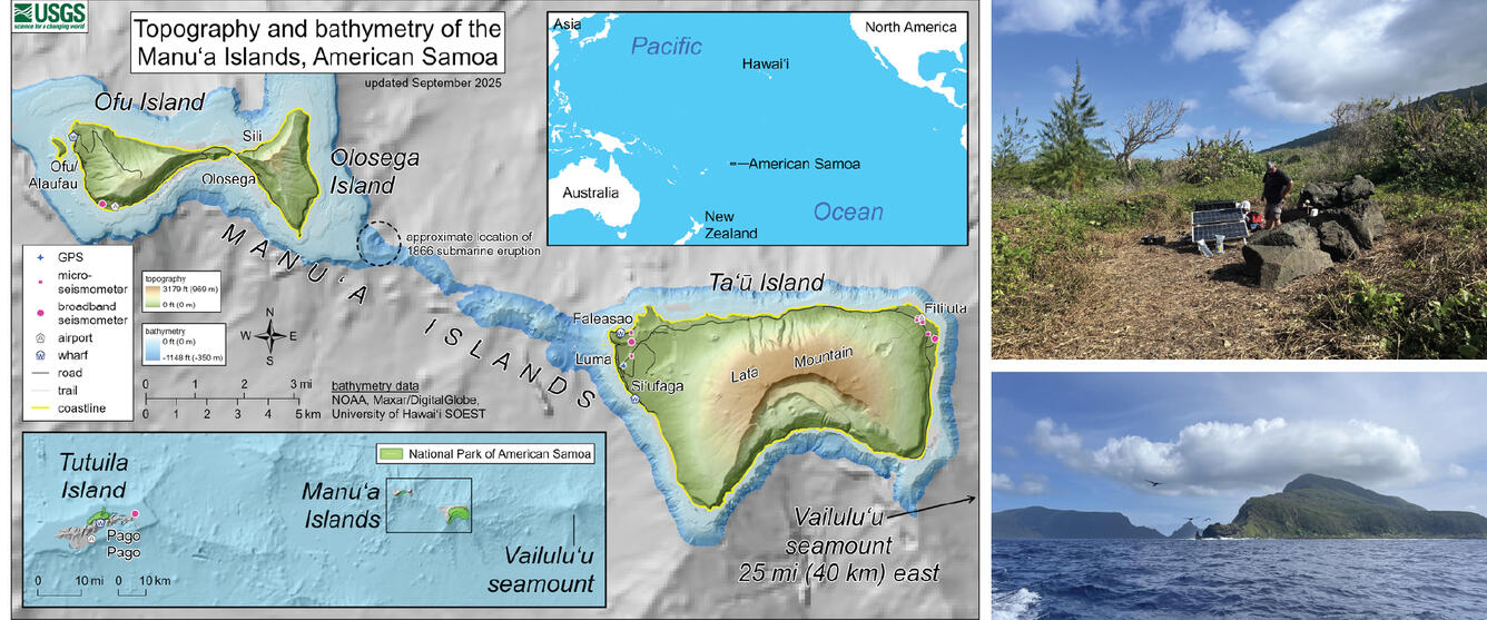
In July 2022, earthquakes at Taʻū volcano shook the remote Manuʻa Islands of American Samoa for 6 weeks as the volcano experienced volcanic unrest; fortunately for the communities of Taʻū Island and nearby Ofu-Olosega Islands (also a volcano), seismic unrest subsided and returned to background levels of activity in September 2022.
As American Samoa is within HVO’s area of responsibility (both the Hawaiian and the Samoan archipelagoes exist because of hot spot volcanism), HVO staff have returned at least once a year since 2022 to bolster collaborations with local partner and maintain the newly established volcano (and earthquake) monitoring network.
All five inhabited islands of American Samoa are volcanic. The main population center, Tutuila, and the nearby Aunuʻu Island, are both part of Tutuila volcano.
Tutuila last erupted around 1500 years ago. Archaeologists have found ceramics below and above volcanic ash associated with this eruption, indicating human settlement at the very least before and after the eruption.
Sixty miles (100 kilometers) to the east of Tutuila, Ofu-Olosega volcano erupted in 1866. Dr. Rev. Turner, a missionary travelling in the area in 1866, described the offshore eruption, which erupted ash through the ocean to altitudes of an estimated 2,000 feet (600 meters) above sea level. The most violent part of the 2-month-long eruption lasted for about three days, exposing the nearest community to ash and volcanic gas and causing them to retreat to a safer location on the island. Dr. Rev. Turner noted that there were no oral traditions recalling previous eruptive activity here (human settlement of the Manuʻa Islands is thought to have occurred about 3,000 years ago).
We do not currently know when the most recent eruption of Taʻū volcano was, but the seismic unrest in 2022 shows it remains potentially active. When unrest started in late July, there was no volcano or earthquake monitoring stations in American Samoa; HVO rapidly installed a seismic network by mid-August. Two GPS stations were installed in early September; one has since been removed. Analysis of the seismic data indicates unrest was centered underneath the northern distal flank of Taʻū volcano.
Similar to the Hawaiian Islands and Kamaʻehuakanaloa, Vailuluʻu is a submarine volcano about 30 miles (45 kilometers) east of Taʻū Island. Repeat oceanic surveys over the past several decades have recorded changes to the seamount consistent with eruptive activity. The most recent confirmed eruption was in 2003, although there may have been more recent activity since.
Although the volcanoes of American Samoa are all currently designated as low threat volcanoes (in contrast, both Kīlauea and Mauna Loa are very high threat volcanoes), the eruptive activity described above, coupled with the 2022 Taʻū unrest, point to the importance of volcano monitoring across the territory. The seismic network in American Samoa is also used by the USGS National Earthquake Information Center and the NOAA Pacific Tsunami Warning Center to locate earthquakes and assess for potential tsunami across the South Pacific.
What did HVO staff do in their most recent visit to American Samoa? Working closely with the NOAA National Weather Service (NWS) Weather Forecast Office of Pago Pago, they visited the Manuʻa Islands. The two agencies, along with the American Samoa Department of Homeland Security (ASDHS), did outreach in the three elementary schools and the sole high school of the Manuʻa Islands. HVO presented on volcanoes and earthquakes, NWS covered hurricanes and effects anticipated as the current El Nino event progresses, and ASDHS focused on tsunami preparedness.
HVO also performed critical maintenance of the monitoring network. Rapid vegetation growth and sea spray greatly affected one of the monitoring stations, requiring extensive vegetation clearing and the replacement of some station components. Both NWS and the NOAA Global Monitoring Laboratory (GML) American Samoa Atmospheric Baseline Observatory provided critical and greatly appreciated support to HVO staff in this undertaking.
Four years on from the 2022 Taʻū volcano unrest, HVO continues to strengthen bonds with local partners and communities. While most of the year HVO remotely keeps an eye on American Samoa, the annual visits are essential for maintaining and strengthening partnerships and the American Samoa monitoring network.
Volcano Activity Updates
Kīlauea has been erupting episodically within the summit caldera since December 23, 2024. Its USGS Volcano Alert level is WATCH.
Lava flows have intermittently erupted from the north vent since September 22, with glow and spatter sometimes visible in the south and west vents. The six new vents that erupted in Halemaʻumaʻu between September 14-16 are no longer active. Irregular summit region inflation, along with earthquakes in and around the caldera, have signaled that Kīlauea's summit region is at a high level of pressurization. Current conditions remain favorable for another fountaining episode or change in eruptive activity if inflation returns. No unusual activity has been noted along Kīlauea’s East Rift Zone or Southwest Rift Zone.
Mauna Loa is not erupting. Its USGS Volcano Alert Level is at NORMAL.
Four earthquakes were reported felt in the Hawaiian Islands during the past week: a M3.2 earthquake 14.5 km (9 mi) SSE of Honaunau-Napoopoo at 7 km (4 mi) depth occurred on September 23 at 2:05 p.m. HST, a M2.8 earthquake 9 km (5 mi) S of Waimea at 11 km (6 mi) depth on September 18 at 7:05 a.m. HST, a M2.5 earthquake 10 km (6 mi) E of Waikoloa at 8 km (5 mi) depth on September 18 at 7:03 a.m. HST, and a M4.1 earthquake 5 km (3 mi) S of Pāhala at 12 km (7 mi) depth on September 17 at 8:36 p.m. HST.
HVO continues to closely monitor Kīlauea and Mauna Loa.
Please visit HVO’s website for past Volcano Watch articles, Kīlauea and Mauna Loa updates, volcano photos, maps, recent earthquake information, and more. Email questions to askHVO@usgs.gov.