
A history of Yellowstone earthquakes
The Yellowstone region is one of the most seismically active areas in the United States, experiencing around 1,500 – 2,500 located earthquakes per year on average.
The majority of these earthquakes are too small to be felt by humans but are detected by sophisticated seismological monitoring equipment. But when did seismic monitoring start in the region? And what sort of earthquakes have been recorded over the past several decades?
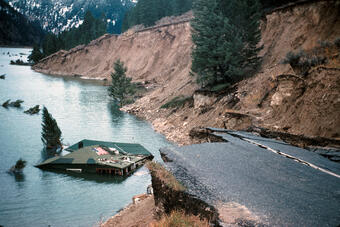
Interest in seismic monitoring of Yellowstone took off after the 1959 magnitude 7.3 Hebgen Lake earthquake, which was located just west of the park boundary and north of West Yellowstone, MT. The event occurred on August 17th, 1959, at 11:37 pm MST and is the largest earthquake to occur in historical times in the Intermountain West. The Hebgen Lake earthquake was responsible for 28 deaths and had a major impact on the hydrothermal systems of nearby Yellowstone National Park, including Old Faithful Geyser. The earthquake triggered a major landslide in Madison Canyon causing 50 million cubic yards of rock to fall to the canyon floor, damming the Madison River and creating Earthquake Lake. In addition, the earthquake triggered many smaller rockfalls in Yellowstone that blocked roadways. Major damage was sustained by many structures in nearby West Yellowstone.
Seismic monitoring in Yellowstone began in earnest during the early 1970's, when a seismic network was installed and operated by the United States Geological Survey (USGS). This network operated until the early 1980's when it was discontinued for budgetary reasons. The network was re-established and expanded by the University of Utah Seismograph Stations (UUSS) in 1984, and it has been operated by UUSS ever since. Over the years, the Yellowstone Seismic Network has been updated with modern digital seismic recording equipment, making it one of the most modern volcano-monitoring networks in the world.
Today, UUSS records data from 46 seismometers in the Yellowstone region. The data are transferred from Yellowstone to the University of Utah in real-time using a sophisticated radio and satellite telemetry system. Given that Yellowstone is a high plateau that experiences heavy snowfall and frigid temperatures much of the year, and that many of the data transmission sites are located on tall peaks, it is a challenge to keep the data flowing during the harsh winter months. It is not uncommon for seismometers to go down for short periods of time because the solar panels or antennas get covered in snow and ice. Sometimes, seismometers that go down during the winter cannot be accessed until the spring.

Since 1973, there have been over 48,000 earthquakes located in the Yellowstone region. Over 99% of those earthquakes are magnitude 2 or below and are not felt by anyone. During that time, there has been one magnitude 6 event—the 1975 M6.1 Norris earthquake located near Norris Geyser Basin (the largest earthquake ever located within Yellowstone National Park). There have also been 2 earthquakes in the magnitude 5 range, 29 earthquakes in the magnitude 4 range, and 379 earthquakes in the magnitude 3 range.
The most recent magnitude 4 event occurred on June 15, 2017, at 5:48 pm local time. The earthquake had a magnitude of 4.4 and was reported felt by over 120 people in Yellowstone National Park and the surrounding communities, including West Yellowstone, MT. The event was part of the Maple Creek Swarm (the 2nd largest swarm recorded in Yellowstone), a cluster of over 2,300 earthquakes that occurred in Yellowstone from June – September, 2017 (for more information, see the January 1, 2018, issue of Yellowstone Caldera Chronicles.
Earthquake swarms (earthquakes that cluster in time and space) account for about 50% of the total seismicity in Yellowstone and can occur anywhere in the Yellowstone region, but they are most common in the east-west band of seismicity between Hebgen Lake and the Norris Geyser Basin. Most swarms are small, containing 10-20 earthquakes, and short, lasting for 1–2 days. However, large swarms that can contain 1,000's of earthquakes and last for months do occur on occasion. Some of the larger swarms are:
| Start Date | End Date | Number of Earthquakes | Location |
| 10/03/85 | 02/17/86 | 3,156 | 5 miles E of West Yellowstone, MT |
| 06/25/95 | 07/09/95 | 439 | 9.6 miles E of West Yellowstone, MT |
| 06/13/99 | 07/16/99 | 722 | 8 miles NE of West Yellowstone, MT |
| 07/31/99 | 08/28/99 | 586 | 9.5 miles NE of West Yellowstone, MT |
| 11/30/01 | 01/09/02 | 480 | 8.8 miles NNE of West Yellowstone, MT |
| 04/12/04 | 04/20/04 | 429 | 9.3 miles NE of West Yellowstone, MT |
| 12/27/08 | 01/07/09 | 811 | 1 mile SE of Lake, WY, YNP |
| 01/15/10 | 02/13/10 | 2,287 | 9.9 miles SE of West Yellowstone, MT |
| 06/12/17 | late Sept, 2017 | >2,400 | 8.9 miles NNE of West Yellowstone, MT |
The UUSS website serves up all located earthquakes and real-time images of the seismic data (as seen on webicorders). You can follow UUSS on Twitter (@UUSS_Quake_Info), to view earthquake information as it happens, and on Facebook where content is regularly added. Check out these feeds for more information about earthquake activity in one of the most seismically active regions in the country!