
A frontal view of the USGS Water Science Center in Louisville, Kentucky.
All Multimedia
Access all multimedia to include images, video, audio, webcams, before-after imagery, and more. Filter and explore with filtering options to refine search.
Filter Total Items: 24923

USGS Louisville KY Main Office
A frontal view of the USGS Water Science Center in Louisville, Kentucky.

USGS scientists collect data from the surfaced Ecomapper AUV
USGS scientists collect data from the surfaced Ecomapper AUV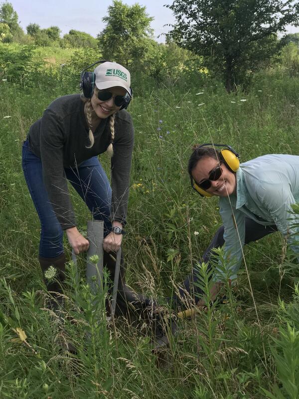
USGS scientists install a double ring infiltrometer
USGS scientists install a double ring infiltrometerIn this photo, USGS scientists Megan Haserodt (Hydrologist) and Jenelle Wempner (Student Intern) install a double ring infiltrometer along a recreated floodplain of Underwood Creek, a tributary to the Milwaukee River and Lake Michigan in Milwaukee, Wisconsin.

View of Half Dome from approximately 2,000’ up El Capitan (Mescalito)
View of Half Dome from approximately 2,000’ up El Capitan (Mescalito)Northeast Region Photo Contest, August 2019, People
View of Half Dome from approximately 2,000’ up El Capitan (Mescalito)
View of Half Dome from approximately 2,000’ up El Capitan (Mescalito)
View of Half Dome from approximately 2,000’ up El Capitan (Mescalito)Northeast Region Photo Contest, August 2019, People
View of Half Dome from approximately 2,000’ up El Capitan (Mescalito)

View South from Wolverine Glacier
View South from Wolverine Glacier
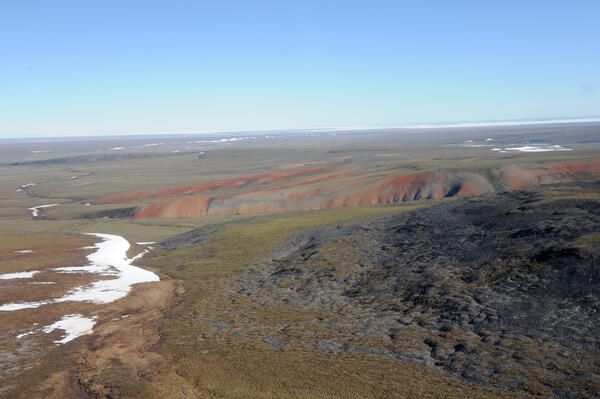
View to northeast from southwestern ANWR-1002 Area; ice in Camden Bay
View to northeast from southwestern ANWR-1002 Area; ice in Camden BayView to northeast from southwestern Arctic National Wildlife Refuge-1002 Area with ice in Camden Bay in distance. In foreground, red-weathering rocks are Hue Shale (oil-prone source rock with is present throughout 1002 Area) and dark gray rocks are Kemik Sandstone (lateral equivalent to Thomson sandstone, main reservoir in Pt. Thomson field).

View to the southeast from near the Canning River Delta
View to the southeast from near the Canning River DeltaView to the southeast from near the Canning River Delta. Visible in foreground are permafrost polygons cut by caribou trails.
Arctic National Wildlife Refuge
View to the southeast from near the Canning River Delta
View to the southeast from near the Canning River DeltaView to the southeast from near the Canning River Delta. Visible in foreground are permafrost polygons cut by caribou trails.
Arctic National Wildlife Refuge

Well head of Sourdough oil discovery on Alaska state lease
Well head of Sourdough oil discovery on Alaska state leaseWell head of Sourdough oil discovery on Alaska state lease less than one mile west of Arctic National Wildlife Refuge-1002 Area showing minimal disturbance of permafrost polygons.
Well head of Sourdough oil discovery on Alaska state lease
Well head of Sourdough oil discovery on Alaska state leaseWell head of Sourdough oil discovery on Alaska state lease less than one mile west of Arctic National Wildlife Refuge-1002 Area showing minimal disturbance of permafrost polygons.

Well on Restored Prairie
A well at a restored prairie on Lake Agassiz beach ridge, Glacial Ridge National Wildlife Refuge
A well at a restored prairie on Lake Agassiz beach ridge, Glacial Ridge National Wildlife Refuge

western ANWR-1002 Area with ice in Camden Bay
Northward view in western Arctic National Wildlife Refuge-1002 Area with ice in Camden Bay in distance. North sloping, tundra-covered surface is typical of coastal plain.
Northward view in western Arctic National Wildlife Refuge-1002 Area with ice in Camden Bay in distance. North sloping, tundra-covered surface is typical of coastal plain.

western Sadlerochit Mountains near the Tamayariak River
western Sadlerochit Mountains near the Tamayariak RiverView to northeast from western Sadlerochit Mountains near the Tamayariak River. This gently rolling topography is typical of the southern coastal plain.
western Sadlerochit Mountains near the Tamayariak River
western Sadlerochit Mountains near the Tamayariak RiverView to northeast from western Sadlerochit Mountains near the Tamayariak River. This gently rolling topography is typical of the southern coastal plain.

Wetlands, Glacial Ridge National Wildlife Refuge
Ephemeral wetlands at Glacial Ridge National Wildlife Refuge
Ephemeral wetlands at Glacial Ridge National Wildlife Refuge
")
What makes a wetland a wetland? (AD - Part 1)
Scientists at the U.S. Geological Survey Wetland and Aquatic Research Center study important aspects of wetlands, such as the flow and quality of water, the chemistry of soil, and the plants and animals which call this ecosystem home.
Scientists at the U.S. Geological Survey Wetland and Aquatic Research Center study important aspects of wetlands, such as the flow and quality of water, the chemistry of soil, and the plants and animals which call this ecosystem home.
")
What makes a wetland a wetland? (Part 1)
Scientists at the U.S. Geological Survey Wetland and Aquatic Research Center study important aspects of wetlands, such as the flow and quality of water, the chemistry of soil, and the plants and animals which call this ecosystem home.
Scientists at the U.S. Geological Survey Wetland and Aquatic Research Center study important aspects of wetlands, such as the flow and quality of water, the chemistry of soil, and the plants and animals which call this ecosystem home.

Why do wetlands matter?
Scientists at the U.S. Geological Survey Wetland and Aquatic Research Center (www.usgs.gov/warc) study important aspects of wetlands, such as the flow and quality of water, the chemistry of soil, and the plants and animals which call this ecosystem home.
Scientists at the U.S. Geological Survey Wetland and Aquatic Research Center (www.usgs.gov/warc) study important aspects of wetlands, such as the flow and quality of water, the chemistry of soil, and the plants and animals which call this ecosystem home.

Will Dougherty carrying snapping turtle
Northeast Region Photo Contest Winner | June 2019 | People
Will Dougherty carrying snapping turtle
Northeast Region Photo Contest Winner | June 2019 | People
Will Dougherty carrying snapping turtle

Wonderful Watery Wetlands - Part 2
Scientists at the U.S. Geological Survey Wetland and Aquatic Research Center (www.usgs.gov/warc) study important aspects of wetlands, such as the flow and quality of water, the chemistry of soil, and the plants and animals which call this ecosystem home.
Scientists at the U.S. Geological Survey Wetland and Aquatic Research Center (www.usgs.gov/warc) study important aspects of wetlands, such as the flow and quality of water, the chemistry of soil, and the plants and animals which call this ecosystem home.
")
Wonderful Watery Wetlands - Part 2 (AD)
Scientists at the U.S. Geological Survey Wetland and Aquatic Research Center (www.usgs.gov/warc) study important aspects of wetlands, such as the flow and quality of water, the chemistry of soil, and the plants and animals which call this ecosystem home.
Scientists at the U.S. Geological Survey Wetland and Aquatic Research Center (www.usgs.gov/warc) study important aspects of wetlands, such as the flow and quality of water, the chemistry of soil, and the plants and animals which call this ecosystem home.

Yosemite toad caught on camera crossing beneath "toad road" structure
Yosemite toad caught on camera crossing beneath "toad road" structureThis is remote capture image of a Yosemite toad seen crossing beneath "toad road" structure built atop a forest road in the Sierra National Forest. Reseachers are exploring tools, such as this elevated road structure, or "toad road," to reduce vehicle strikes to this threatened species.

Young Moose, Glacial Ridge National Wildlife Refuge
Young Moose, Glacial Ridge National Wildlife RefugeYoung moose near Benoit, Minnesota, Glacial Ridge National Wildlife Refuge
Young Moose, Glacial Ridge National Wildlife Refuge
Young Moose, Glacial Ridge National Wildlife RefugeYoung moose near Benoit, Minnesota, Glacial Ridge National Wildlife Refuge

Taking water quality samples in Alaska
Earl Alstrom and Carol Hasburgh taking water quality samples near St. Mary’s, Alaska.
Earl Alstrom and Carol Hasburgh taking water quality samples near St. Mary’s, Alaska.