
Gas hydrate is sometimes called “the ice that burns” because the warming hydrates release enough methane to sustain a flame. Credit: USGS
Images
Explore our planet through photography and imagery, including climate change and water all the way back to the 1800s when the USGS was surveying the country by horse and buggy.
Filter Total Items: 21351
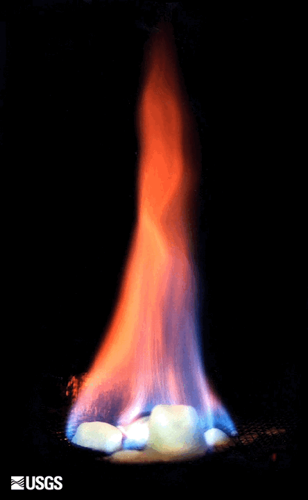
Burning Gas Hydrate
Gas hydrate is sometimes called “the ice that burns” because the warming hydrates release enough methane to sustain a flame. Credit: USGS

California Horizontal ADVM mount 1
Protective housing prevents damage to ADVM and allows for adjustment of heading and roll.
Protective housing prevents damage to ADVM and allows for adjustment of heading and roll.

California Horizontal ADVM mount 2
Protective housing prevents damage to ADVM and allows for adjustment of heading and roll.
Protective housing prevents damage to ADVM and allows for adjustment of heading and roll.

Camden Bay from west-central ANWR-1002 Area
Northward view towards Camden Bay from west-central Arctic National Wildlife Refuge-1002 Area near the Katakturuk River. Patterns in foreground are permafrost polygons.
Northward view towards Camden Bay from west-central Arctic National Wildlife Refuge-1002 Area near the Katakturuk River. Patterns in foreground are permafrost polygons.

Camden Bay from west-central ANWR-1002 Area
View to the northeast towards Camden Bay from west-central Arctic National Wildlife Refuge-1002 Area. The tundra and lakes in this area displays a variety of patterns caused by permafrost.
View to the northeast towards Camden Bay from west-central Arctic National Wildlife Refuge-1002 Area. The tundra and lakes in this area displays a variety of patterns caused by permafrost.

Canning River Delta with thin barrier island and ice pack
Canning River Delta with thin barrier island and ice packNorthward view to coast of Canning River Delta with thin barrier island and ice pack beyond.
Canning River Delta with thin barrier island and ice pack
Canning River Delta with thin barrier island and ice packNorthward view to coast of Canning River Delta with thin barrier island and ice pack beyond.

central ANWR-1002 Area near the Sadlerochit River
Northward view in central Arctic National Wildlife Refuge-1002 Area near the Sadlerochit River showing gently rolling topography typical of the southern coastal plain.
Northward view in central Arctic National Wildlife Refuge-1002 Area near the Sadlerochit River showing gently rolling topography typical of the southern coastal plain.

Closeup view of oil-saturated Oligocene sandstone in the Sagavanirktok
Closeup view of oil-saturated Oligocene sandstone in the SagavanirktokCloseup view of oil-saturated Oligocene sandstone in the Sagavanirktok Formation exposed on Marsh Creek anticline near Katakturuk River in western Arctic National Wildlife Refuge-1002 Area. Weathered surface is light gray and freshly broken surface is brown.

Collection samples hourly at a private domestic bedrock well
Collection samples hourly at a private domestic bedrock wellAssessing the variability of arsenic over multiple time scales project.
Collection samples hourly at a private domestic bedrock well, Seabrook, New Hampshire.
Collection samples hourly at a private domestic bedrock well
Collection samples hourly at a private domestic bedrock wellAssessing the variability of arsenic over multiple time scales project.
Collection samples hourly at a private domestic bedrock well, Seabrook, New Hampshire.

Color-shaded topographic relief map of Yellowstone Plateau Snake River
Color-shaded topographic relief map of Yellowstone Plateau Snake RiverColor-shaded topographic relief map of the Yellowstone Plateau-Snake River Plain volcanic province showing the track of the Yellowstone hot spot.
Color-shaded topographic relief map of Yellowstone Plateau Snake River
Color-shaded topographic relief map of Yellowstone Plateau Snake RiverColor-shaded topographic relief map of the Yellowstone Plateau-Snake River Plain volcanic province showing the track of the Yellowstone hot spot.

Contrasting photos of Heart Spring from 1988 and 2019 Yellowstone
Contrasting photos of Heart Spring from 1988 and 2019 YellowstoneContrasting photos of Heart Spring on Geyser Hill in the Upper Geyser Basin from 1998 (left) and 2019 (right). Can you spot differences in the hot spring? Photos courtesy of the National Park Service.

Custom Boogie Board 1
Photograph of custom boogie board for ADCP deploymet, view of bottom.
Photograph of custom boogie board for ADCP deploymet, view of bottom.

Custom Boogie Board 2
Photograph of custom boogie board for ADCP deploymet, view of bottom.
Photograph of custom boogie board for ADCP deploymet, view of bottom.

Custom Boogie Board 3
Photograph of custom boogie board for ADCP deploymet, view of bottom.
Photograph of custom boogie board for ADCP deploymet, view of bottom.

Densmore uses ultrasound
Dr. Christine Densmore, DVM uses an ultrasound on fish as part of a health assessment.
Dr. Christine Densmore, DVM uses an ultrasound on fish as part of a health assessment.

Digital elevation model from the 2019 LiDAR survey of Kīlauea
Digital elevation model from the 2019 LiDAR survey of KīlaueaA sample of the digital elevation model from the 2019 LiDAR survey of Kīlauea, showing the vicinity of the former HVO office and Jaggar Museum in Hawaiʻi Volcanoes National Park.

Earth MRI - Common Uses of Rare Earth Elements
Earth MRI - Common Uses of Rare Earth Elements

Earth MRI - Forty mile River Watershed
Earth MRI - Forty mile River Watershed

Earth MRI - High Grade Rare Earth Elements Bearing Phosphorite
Earth MRI - High Grade Rare Earth Elements Bearing PhosphoriteEarth MRI - High Grade Rare Earth Elements Bearing Phosphorite
Earth MRI - High Grade Rare Earth Elements Bearing Phosphorite
Earth MRI - High Grade Rare Earth Elements Bearing PhosphoriteEarth MRI - High Grade Rare Earth Elements Bearing Phosphorite

Earth MRI - Rare Earth Elements Deposit
Earth MRI - Rare Earth Elements Deposit

Earth MRI Geologic map of the Castle Rock quadrangle AZ
Earth MRI Geologic map of the Castle Rock quadrangle AZEarth MRI Geologic map of the Castle Rock quadrangle AZ
Earth MRI Geologic map of the Castle Rock quadrangle AZ
Earth MRI Geologic map of the Castle Rock quadrangle AZEarth MRI Geologic map of the Castle Rock quadrangle AZ