



A mid-ocean ridge revealed by 3D magnetic modeling: New geologic map of Escanaba Trough
Nearly two hundred miles offshore of the Oregon/California border lies Escanaba Trough, a unique mid-ocean ridge covered in deep sediment up to 500 meters thick, dotted with active hydrothermal vent systems. Detailed study of its geologic structure has long been hindered by those thick layers of sediment—until now.
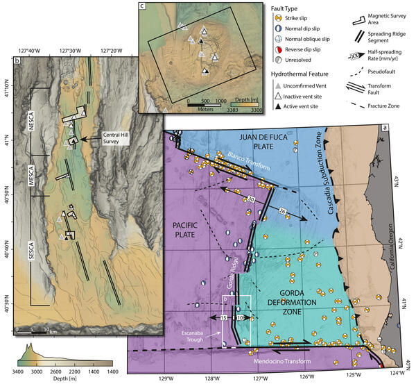
A new study from USGS and partners uses advanced remote-sensing techniques to provide a high-resolution view of this deep-sea volcanic setting. The research combines new geologic mapping with three-dimensional magnetic modeling to reveal how submarine volcanoes, magma intrusions, and hydrothermal vents formed along one of the world's few sediment-covered mid-ocean ridges.
A mid-ocean ridge unlike most others
Mid-ocean ridges form the longest volcanic mountain chains on Earth, stretching tens of thousands of miles across the ocean floor where tectonic plates slowly move apart.
Most are relatively free of sediment, allowing volcanic features to remain exposed on the seafloor. Escanaba Trough, however, is different.
Its proximity to the North American continent means that rivers and continental-shelf erosion have buried much of the ridge beneath thick deposits of sediment, creating a distinctive hydrothermal environment where magma-heated seawater interacts with layers of mud and sand, supporting specialized chemosynthetic ecosystems and in some cases leading to the formation of large mineral deposits known as seafloor massive sulfides.
Mapping a buried hydrothermal system

Using multiple remote-sensing datasets collected during a 2022 expedition, researchers developed a new geologic map of Escanaba Trough that allowed them to estimate the volume of volcanic material emplaced below the seafloor and better understand why volcanic activity is concentrated within three distinct volcanic centers at the site.
For the three-dimensional magnetic modeling, the autonomous underwater vehicle Sentry flew close to the seafloor, recording subtle variations in Earth's magnetic field created by volcanic rocks beneath the sediments.
From these observations, scientists developed six 3D magnetic models that revealed the emplacement and geometry of buried magma intrusions, volcanic structures, and hydrothermal vent systems. These models provide one of the clearest views yet of volcanic plumbing hidden beneath a heavily sedimented mid-ocean ridge.
With the underlying magma bodies revealed, researchers could now better understand why Escanaba Trough’s hydrothermal vent systems occur where they do. Understanding these relationships is important for studying submarine volcanism, mineral formation, and the unique biological communities that thrive around deep-sea vents. The combination of high-resolution geologic mapping and near-bottom magnetic surveys demonstrates how emerging remote-sensing technologies can create detailed models of volcanic systems that traditional seafloor mapping cannot fully resolve.
Related

Global Seabed Mineral Resources
Related