
Using Distant Seismometers to Monitor and Analyze Volcanic Eruptions
Before a volcano erupts, there are typically precursory activities that can be detected on seismometers. Thus, monitoring volcanoes with nearby seismometers is a good way to know when a volcanic eruption may be imminent. Placing these instruments around every volcano is, however, not possible due to logistical constraints, nor is it necessary in many locations far away from a population center.
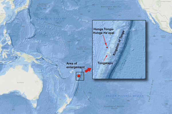
Indeed, there are more than 1000 active volcanoes on the planet that are not locally monitored, and some of them are very near potentially impacted populations. One such location is the Tongan capital of Nukuʻalofa, where the only warnings before the nearby (70 km south; 44 mi) Hunga Tonga-Hunga Haʻapai (HTHH) volcano violently erupted on January 15, 2022, were some observed low-energy eruptions starting December 20, 2021, on the islands that form the northwest rim of the submerged caldera.
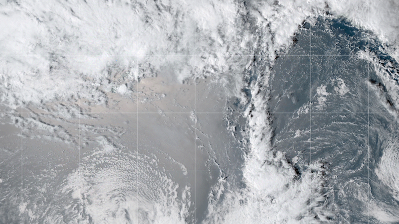
With a Volcanic Explosivity Index (VEI) of about 6, the 2022 HTHH eruption was one of the largest volcanic eruptions in the past century. The underwater explosion caused a tsunami and a huge plume 58 km (36 mi) high, “two and a half times higher than any thunderstorm ever observed,” reported NASA. The tsunami destroyed homes on nearby islands and then continued out across the ocean. The explosion created abundant local lightning, a sonic boom that was heard as far away as Alaska, and rare atmospheric shock waves that circled the planet.
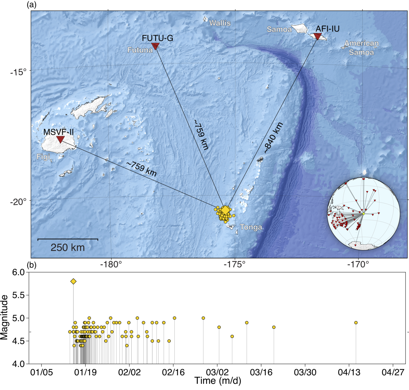
Earthquakes typically occur before and during an explosive eruption. When the earthquakes became larger and more frequent after the main HTHH eruption, it appeared a second violent eruption may be on the way. With the closest seismometer about 750 km (466 mi) away, however, it was difficult to analyze the seismic activity and impossible to even record the small earthquakes. A nearby seismometer, or better yet, several nearby seismometers, would have made it possible to quickly detect and record all the details that would give clues about what was going on in the caldera. For example, a precursory earthquake occurred five days earlier that was initially undetected by the standard processing techniques.
Without any local seismometers, seismologists at the National Earthquake Information Center (NEIC) had to rely solely on data recorded on the distant seismometers. Although not as straightforward as using nearby recordings, the scientists were able to glean important information about the activity going on beneath and around the caldera before, during, and after the main eruption. The methods they developed could be used for other volcanoes that do not have local monitoring in the event they become more active and threaten a local population.
Usually, the largest and most numerous earthquakes occur before and during the main eruption and then decrease in size and frequency. When the size and frequency of earthquakes remained high after the violent HTHH eruption, there was concern that another large eruption may occur. But without accurate measurements of locations and magnitudes of all the earthquake activity in the area, it was difficult to determine what was going on in the caldera and what the consequences may be. Fortunately, the seismicity decayed after several weeks without a further significant eruptive episode.
By combining all the data and using mathematical tools to detect, locate, and estimate the magnitude of earthquakes associated with the volcano, the scientists were able to reconstruct the complex sequence of events surrounding the eruption. There were 4 shallow pre-eruption seismic events: one on January 10 that had not been identified before this research, one on January 14, and two within 10 minutes of the initiation of the main eruption. In the year preceding the eruption there had been no shallow earthquakes recorded within 50 km of the volcano.
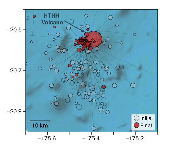
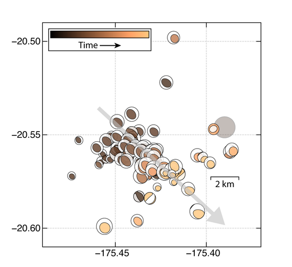
The initial activity associated with the eruption was focused in a 25 km2 (16 mi2) area near the volcanic vent, increased in frequency and magnitude to about 20 earthquakes per day of magnitude 4.5 or greater, peaked on January 18, 2021, and then decreased. Within a few days after the eruption, the locations of the earthquakes migrated to the southeast of the vent. [F5a.pdf] The scientists think this earthquake behavior indicates the collapse of the caldera followed by subsequent rapid magma movement to refill the vacated shallow (<10 km; <6 mi) magma chamber.
The scientists who completed this study suggest that their techniques could be more broadly used to monitor additional volcanoes that do not have nearby seismic stations. The use of more distant seismic instruments to monitor volcanic activity could help detect precursory earthquakes that are typical before large explosive eruptions. Remote monitoring of the seismicity following eruptions could also help determine the level and nature of subsequent remaining hazards. In the absence of local volcano monitoring, this technique may provide the warning needed to save lives in the nearby vicinity of an active volcano.
~ written by Lisa Wald, November 30, 2022
For More Information
- Jonas A. Kintner, William L. Yeck, Paul S. Earle, Stephanie Prejean, Jeremy D. Pesicek; High-Precision Characterization of Seismicity from the 2022 Hunga Tonga-Hunga Ha'apai Volcanic Eruption. Seismological Research Letters 2022.
- In depth: Surprising tsunamis caused by explosive eruption in Tonga
The Scientists Behind the Science
The USGS scientists who co-authored this research are below.
Will Yeck is a research geophysicist at the USGS National Earthquake Information Center. His research is aimed at improving our ability to rapidly and accurately characterize earthquakes as well as interpret the seismotectonics of significant events. He has led the development of many core NEIC earthquake processing elements. In his free time, Will likes to trail-run, climb, and read.

Paul Earle’s primary responsibility is oversight of 24/7 earthquake monitoring. He guides the development and implementation of new policies and procedures used during earthquake response and catalog production. He also serves in the rotating role of National Earthquake Information Center (NEIC) event coordinator, overseeing the production of near-real-time products following earthquake disasters around the globe. When he’s not responding to an earthquake, he can often be found doing long-distance skate-boarding.

Stephanie Prejean joined the USGS in 2002 immediately after completing her Ph.D. in geophysics at Stanford University. In 2015 she started working with the USGS-USAID Volcano Disaster Assistance Program, which assists local scientists with volcanic unrest all around the world. Her research is focused on eruption forecasting and understanding the physical processes that trigger seismicity at active volcanoes. Outside of work, she enjoys spending time gardening and hiking with her dog, Ginger.
Jeremy Pesicek is a research geophysicist at the USGS-USAID Volcano Disaster Assistance Program. He studies earthquakes and earthquake sequences that occur near active volcanoes around the world in order to better understand their internal structures and improve eruption forecasts. In his free time, Jeremy can be found fly fishing, backpacking, and canoeing in the Pacific Northwest.
Jonas A Kintner, the first author, is a scientist at Los Alamos National Laboratory.
Before a volcano erupts, there are typically precursory activities that can be detected on seismometers. Thus, monitoring volcanoes with nearby seismometers is a good way to know when a volcanic eruption may be imminent. Placing these instruments around every volcano is, however, not possible due to logistical constraints, nor is it necessary in many locations far away from a population center.
Indeed, there are more than 1000 active volcanoes on the planet that are not locally monitored, and some of them are very near potentially impacted populations. One such location is the Tongan capital of Nukuʻalofa, where the only warnings before the nearby (70 km south; 44 mi) Hunga Tonga-Hunga Haʻapai (HTHH) volcano violently erupted on January 15, 2022, were some observed low-energy eruptions starting December 20, 2021, on the islands that form the northwest rim of the submerged caldera.
With a Volcanic Explosivity Index (VEI) of about 6, the 2022 HTHH eruption was one of the largest volcanic eruptions in the past century. The underwater explosion caused a tsunami and a huge plume 58 km (36 mi) high, “two and a half times higher than any thunderstorm ever observed,” reported NASA. The tsunami destroyed homes on nearby islands and then continued out across the ocean. The explosion created abundant local lightning, a sonic boom that was heard as far away as Alaska, and rare atmospheric shock waves that circled the planet.
Earthquakes typically occur before and during an explosive eruption. When the earthquakes became larger and more frequent after the main HTHH eruption, it appeared a second violent eruption may be on the way. With the closest seismometer about 750 km (466 mi) away, however, it was difficult to analyze the seismic activity and impossible to even record the small earthquakes. A nearby seismometer, or better yet, several nearby seismometers, would have made it possible to quickly detect and record all the details that would give clues about what was going on in the caldera. For example, a precursory earthquake occurred five days earlier that was initially undetected by the standard processing techniques.
Without any local seismometers, seismologists at the National Earthquake Information Center (NEIC) had to rely solely on data recorded on the distant seismometers. Although not as straightforward as using nearby recordings, the scientists were able to glean important information about the activity going on beneath and around the caldera before, during, and after the main eruption. The methods they developed could be used for other volcanoes that do not have local monitoring in the event they become more active and threaten a local population.
Usually, the largest and most numerous earthquakes occur before and during the main eruption and then decrease in size and frequency. When the size and frequency of earthquakes remained high after the violent HTHH eruption, there was concern that another large eruption may occur. But without accurate measurements of locations and magnitudes of all the earthquake activity in the area, it was difficult to determine what was going on in the caldera and what the consequences may be. Fortunately, the seismicity decayed after several weeks without a further significant eruptive episode.
By combining all the data and using mathematical tools to detect, locate, and estimate the magnitude of earthquakes associated with the volcano, the scientists were able to reconstruct the complex sequence of events surrounding the eruption. There were 4 shallow pre-eruption seismic events: one on January 10 that had not been identified before this research, one on January 14, and two within 10 minutes of the initiation of the main eruption. In the year preceding the eruption there had been no shallow earthquakes recorded within 50 km of the volcano.
The initial activity associated with the eruption was focused in a 25 km2 (16 mi2) area near the volcanic vent, increased in frequency and magnitude to about 20 earthquakes per day of magnitude 4.5 or greater, peaked on January 18, 2021, and then decreased. Within a few days after the eruption, the locations of the earthquakes migrated to the southeast of the vent. [F5a.pdf] The scientists think this earthquake behavior indicates the collapse of the caldera followed by subsequent rapid magma movement to refill the vacated shallow (<10 km; <6 mi) magma chamber.
The scientists who completed this study suggest that their techniques could be more broadly used to monitor additional volcanoes that do not have nearby seismic stations. The use of more distant seismic instruments to monitor volcanic activity could help detect precursory earthquakes that are typical before large explosive eruptions. Remote monitoring of the seismicity following eruptions could also help determine the level and nature of subsequent remaining hazards. In the absence of local volcano monitoring, this technique may provide the warning needed to save lives in the nearby vicinity of an active volcano.
~ written by Lisa Wald, November 30, 2022
For More Information
- Jonas A. Kintner, William L. Yeck, Paul S. Earle, Stephanie Prejean, Jeremy D. Pesicek; High-Precision Characterization of Seismicity from the 2022 Hunga Tonga-Hunga Ha'apai Volcanic Eruption. Seismological Research Letters 2022.
- In depth: Surprising tsunamis caused by explosive eruption in Tonga
The Scientists Behind the Science
The USGS scientists who co-authored this research are below.
Will Yeck is a research geophysicist at the USGS National Earthquake Information Center. His research is aimed at improving our ability to rapidly and accurately characterize earthquakes as well as interpret the seismotectonics of significant events. He has led the development of many core NEIC earthquake processing elements. In his free time, Will likes to trail-run, climb, and read.
Paul Earle’s primary responsibility is oversight of 24/7 earthquake monitoring. He guides the development and implementation of new policies and procedures used during earthquake response and catalog production. He also serves in the rotating role of National Earthquake Information Center (NEIC) event coordinator, overseeing the production of near-real-time products following earthquake disasters around the globe. When he’s not responding to an earthquake, he can often be found doing long-distance skate-boarding.
Stephanie Prejean joined the USGS in 2002 immediately after completing her Ph.D. in geophysics at Stanford University. In 2015 she started working with the USGS-USAID Volcano Disaster Assistance Program, which assists local scientists with volcanic unrest all around the world. Her research is focused on eruption forecasting and understanding the physical processes that trigger seismicity at active volcanoes. Outside of work, she enjoys spending time gardening and hiking with her dog, Ginger.
Jeremy Pesicek is a research geophysicist at the USGS-USAID Volcano Disaster Assistance Program. He studies earthquakes and earthquake sequences that occur near active volcanoes around the world in order to better understand their internal structures and improve eruption forecasts. In his free time, Jeremy can be found fly fishing, backpacking, and canoeing in the Pacific Northwest.
Jonas A Kintner, the first author, is a scientist at Los Alamos National Laboratory.