
2024 Pedersen Glacier Lagoon Landslide-Generated Tsunami
A 4.6-million-cubic-meter (equivalent to over 184 Olympic-sized swimming pools) landslide produced a tsunami in Pedersen Glacier lagoon, southwest of Seward, Alaska on Wednesday, August 7th, 2024, at approximately 04:55 AKDT / 12:55 UTC. Surveying indicated that the landslide generated tsunami runup of at least 17 meters (approx. 56 ft) in the upper Pedersen Glacier lagoon*, reducing to about one meter high (approx. 3 feet) in the lower Pedersen Glacier lagoon. No injuries or fatalities were reported.
The LASER response team has been deactivated after concluding our requested emergency response tasks. This page may be updated with new findings and publications related to the event. Last update: 04/27/26.
Satellite imagery, an overflight, geophysical data, and field reconnaissance provided the observations for the following summary.
* The geography of Alaska’s coast is everchanging as glaciers rapidly retreat, and not all geographic locations may have recorded names. On this event page, Pedersen Glacier’s proglacial lake is referred to as “upper Pedersen Glacier lagoon” and “the upper lagoon,” and the associated, tidally-influenced lower lagoon is referred to here as “lower Pedersen Glacier lagoon” and “the lower lagoon.”
Field Photos | Findings | More Information | Publications | Data
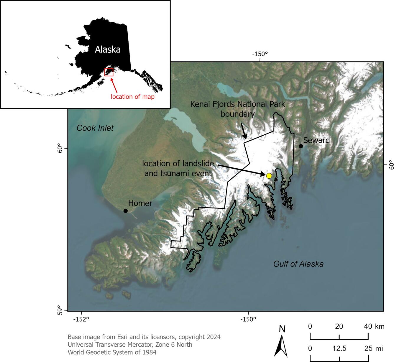
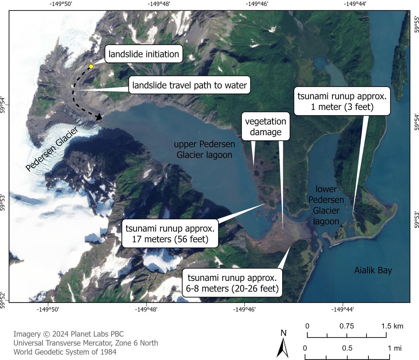
A landslide occurred in the early morning on Wednesday, August 7th, 2024, at a latitude/longitude of approximately 59.9038°N, 149.8246°W (all coordinates in World Geodetic System 1983), on a southwest-facing slope above the terminus of Pedersen Glacier. The landslide traveled downslope and then along the glacier and entered upper Pedersen Glacier lagoon, producing a local tsunami that traveled across the upper lagoon to the lower lagoon, where it damaged wooden boardwalks in the tidal zone at a lodge and affected a National Park Service campsite easement by damaging a food storage box. No known injuries or fatalities were reported. Witnesses at the lodge reported a loud "thunderous sound" and witnessed "a two-to-three-foot wave or set of waves that flowed up to the cabins" (as reported by Kirk Hoessle of Alaska Wildland Adventures on August 10, 2024). The tide was ebbing and reportedly 3 meters (approx. 10 feet) at the time of the event. Photos from an overflight on August 9th, 2024 confirmed the landslide occurrence and location.
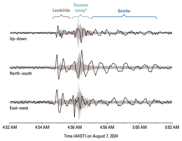
Ground-based surveying by the National Park Service indicated that the tsunami runup was about 17 meters high (approx. 56 ft) at a distal portion of the lagoon (59.9029°N, 149.8016°W), traveled across a portion of the landform between the two lagoons, and reduced to about one meter high (approx. 2-3 feet) in eastern portions of the lower lagoon. Seismic detection by the USGS and the Alaska Earthquake Center indicated that the landslide occurred at 04:54:49 AKDT / 12:54:49 UTC. During the tsunami event, seismic signals indicate that a seiche, or an oscillating wave, likely formed.


The National Park Service has estimated the landslide volume to be 4.6 million meters (+/-0.7 million cubic meters) (approx. 6 million cubic yards). This estimate was made by creating a post-event terrain elevation model based on processing numerous photographs taken by helicopter and comparing that to the pre-event terrain elevations. The aerial photographs and resulting post-landslide terrain model used to make this estimate are available for download from the NPS DataStore.1
The landslide occurred in a rock unit called the Chugach flysch, which is composed of tectonically deformed and metamorphosed sandstone and siltstone that formed 145 to 66 million years ago.2
In June 2025, the National Park Service conducted a water depth survey in the fjord to better inform tsunami modeling and found it reached a maximum depth of 187 meters (approx. 205 yards).3
Regional Background
Landslides that form above, and which could fail into waterbodies including lakes, fjords, and bays, are relatively common in the steep and glaciated mountains of Alaska.4,5,6 According to the National Park Service, upper Pedersen Glacier lagoon has experienced at least one other landslide-generated tsunami in April 2022, which is not known to have reached the lodge on the eastern shore of the lower Pedersen Glacier lagoon. As populations, infrastructure, recreation, and commercial activities expand into lakes and coastal waterways where landslides are common, risks increase. The U.S. Geological Survey (USGS) and our partners at the Alaska Division of Geological & Geophysical Surveys (DGGS), National Oceanic and Atmospheric Administration (NOAA), Alaska Earthquake Center (AEC), and National Park Service (NPS) are engaged in scientific studies to better understand the extent and magnitude of the hazard presented by landslides and landslide-generated tsunami in Alaska’s coastal waterways and large lakes.


Data Release link:
Orthomosaics and Digital Surface Models: https://irma.nps.gov/DataStore/Reference/Profile/2310424https://irma.nps.gov/DataStore/Reference/Profile/2310424
Contributors to this page include Lauren Schaefer (USGS), Marísa Macías (USGS), Liam Toney (USGS), Stephen Slaughter (USGS), Dennis Staley (USGS), Matt Haney (USGS), Nicole Abib (NPS), Sarah Venator (NPS), Ezgi Karasözen (AEC), and Kirk Hoessle and Jeff Pedersen (Alaska Wildland Adventures).
More Information
Read the Kenai Fjords National Park press release.
Learn more about the Kenai Fjords National Park.
Learn more about the Landslide Hazards Program.
Learn more about USGS Landslide Response.
References
1Kennedy, T., Hults, C., Venator, S., Abib, N., and Cusick, J, 2025, 2024 KEFJ Pedersen Lagoon Landslide SfM Imagery and GNSS. National Park Service. Pedersen Lagoon, Kenai Fjords National Park. https://doi.org/10.57830/2310424
2Wilson, F.H., Hults, C.P., Mull, C.G, and Karl, S.M, 2015, Geologic map of Alaska: U.S. Geological Survey Scientific Investigations Map 3340, pamphlet 196 p., 2 sheets, scale 1:1,584,000. https://doi.org/10.3133/sim3340
3Laroch, N. and LaFrance Bartley, M, 2025, Pedersen lagoon bathymetric survey June 2025, Kenai Fjords National Park. National Park Service. https://irma.nps.gov/DataStore/Reference/Profile/2315908
4Miller, D.J, 1960, The Alaska earthquake of July 10, 1958: Giant wave in Lituya Bay: Bulletin of the Seismological Society of America 50(2): 253-266. https://doi.org/10.1785/BSSA0500020253
5Coe, J.A., Bessette-Kirton, E.K., and Geertsema, M., 2018, Increasing rock-avalanche size and mobility in Glacier Bay National Park and Preserve, Alaska detected from 1984 to 2016 Landsat imagery: Landslides 15, 393–407. https://doi.org/10.1007/s10346-017-0879-7
6Schaefer, L.N., Kim, J., Staley, D.M., Lu, Z., and Barnhart, K.R., 2024, Satellite interferometry landslide detection and preliminary tsunamigenic plausibility assessment in Prince William Sound, southcentral Alaska: U.S. Geological Survey Open-File Report 2023–1099, 22 p., https://doi.org/10.3133/ofr20231099
A 4.6-million-cubic-meter (equivalent to over 184 Olympic-sized swimming pools) landslide produced a tsunami in Pedersen Glacier lagoon, southwest of Seward, Alaska on Wednesday, August 7th, 2024, at approximately 04:55 AKDT / 12:55 UTC. Surveying indicated that the landslide generated tsunami runup of at least 17 meters (approx. 56 ft) in the upper Pedersen Glacier lagoon*, reducing to about one meter high (approx. 3 feet) in the lower Pedersen Glacier lagoon. No injuries or fatalities were reported.
The LASER response team has been deactivated after concluding our requested emergency response tasks. This page may be updated with new findings and publications related to the event. Last update: 04/27/26.
Satellite imagery, an overflight, geophysical data, and field reconnaissance provided the observations for the following summary.
* The geography of Alaska’s coast is everchanging as glaciers rapidly retreat, and not all geographic locations may have recorded names. On this event page, Pedersen Glacier’s proglacial lake is referred to as “upper Pedersen Glacier lagoon” and “the upper lagoon,” and the associated, tidally-influenced lower lagoon is referred to here as “lower Pedersen Glacier lagoon” and “the lower lagoon.”
Field Photos | Findings | More Information | Publications | Data
A landslide occurred in the early morning on Wednesday, August 7th, 2024, at a latitude/longitude of approximately 59.9038°N, 149.8246°W (all coordinates in World Geodetic System 1983), on a southwest-facing slope above the terminus of Pedersen Glacier. The landslide traveled downslope and then along the glacier and entered upper Pedersen Glacier lagoon, producing a local tsunami that traveled across the upper lagoon to the lower lagoon, where it damaged wooden boardwalks in the tidal zone at a lodge and affected a National Park Service campsite easement by damaging a food storage box. No known injuries or fatalities were reported. Witnesses at the lodge reported a loud "thunderous sound" and witnessed "a two-to-three-foot wave or set of waves that flowed up to the cabins" (as reported by Kirk Hoessle of Alaska Wildland Adventures on August 10, 2024). The tide was ebbing and reportedly 3 meters (approx. 10 feet) at the time of the event. Photos from an overflight on August 9th, 2024 confirmed the landslide occurrence and location.
Ground-based surveying by the National Park Service indicated that the tsunami runup was about 17 meters high (approx. 56 ft) at a distal portion of the lagoon (59.9029°N, 149.8016°W), traveled across a portion of the landform between the two lagoons, and reduced to about one meter high (approx. 2-3 feet) in eastern portions of the lower lagoon. Seismic detection by the USGS and the Alaska Earthquake Center indicated that the landslide occurred at 04:54:49 AKDT / 12:54:49 UTC. During the tsunami event, seismic signals indicate that a seiche, or an oscillating wave, likely formed.
The National Park Service has estimated the landslide volume to be 4.6 million meters (+/-0.7 million cubic meters) (approx. 6 million cubic yards). This estimate was made by creating a post-event terrain elevation model based on processing numerous photographs taken by helicopter and comparing that to the pre-event terrain elevations. The aerial photographs and resulting post-landslide terrain model used to make this estimate are available for download from the NPS DataStore.1
The landslide occurred in a rock unit called the Chugach flysch, which is composed of tectonically deformed and metamorphosed sandstone and siltstone that formed 145 to 66 million years ago.2
In June 2025, the National Park Service conducted a water depth survey in the fjord to better inform tsunami modeling and found it reached a maximum depth of 187 meters (approx. 205 yards).3
Regional Background
Landslides that form above, and which could fail into waterbodies including lakes, fjords, and bays, are relatively common in the steep and glaciated mountains of Alaska.4,5,6 According to the National Park Service, upper Pedersen Glacier lagoon has experienced at least one other landslide-generated tsunami in April 2022, which is not known to have reached the lodge on the eastern shore of the lower Pedersen Glacier lagoon. As populations, infrastructure, recreation, and commercial activities expand into lakes and coastal waterways where landslides are common, risks increase. The U.S. Geological Survey (USGS) and our partners at the Alaska Division of Geological & Geophysical Surveys (DGGS), National Oceanic and Atmospheric Administration (NOAA), Alaska Earthquake Center (AEC), and National Park Service (NPS) are engaged in scientific studies to better understand the extent and magnitude of the hazard presented by landslides and landslide-generated tsunami in Alaska’s coastal waterways and large lakes.
Data Release link:
Orthomosaics and Digital Surface Models: https://irma.nps.gov/DataStore/Reference/Profile/2310424https://irma.nps.gov/DataStore/Reference/Profile/2310424
Contributors to this page include Lauren Schaefer (USGS), Marísa Macías (USGS), Liam Toney (USGS), Stephen Slaughter (USGS), Dennis Staley (USGS), Matt Haney (USGS), Nicole Abib (NPS), Sarah Venator (NPS), Ezgi Karasözen (AEC), and Kirk Hoessle and Jeff Pedersen (Alaska Wildland Adventures).
More Information
Read the Kenai Fjords National Park press release.
Learn more about the Kenai Fjords National Park.
Learn more about the Landslide Hazards Program.
Learn more about USGS Landslide Response.
References
1Kennedy, T., Hults, C., Venator, S., Abib, N., and Cusick, J, 2025, 2024 KEFJ Pedersen Lagoon Landslide SfM Imagery and GNSS. National Park Service. Pedersen Lagoon, Kenai Fjords National Park. https://doi.org/10.57830/2310424
2Wilson, F.H., Hults, C.P., Mull, C.G, and Karl, S.M, 2015, Geologic map of Alaska: U.S. Geological Survey Scientific Investigations Map 3340, pamphlet 196 p., 2 sheets, scale 1:1,584,000. https://doi.org/10.3133/sim3340
3Laroch, N. and LaFrance Bartley, M, 2025, Pedersen lagoon bathymetric survey June 2025, Kenai Fjords National Park. National Park Service. https://irma.nps.gov/DataStore/Reference/Profile/2315908
4Miller, D.J, 1960, The Alaska earthquake of July 10, 1958: Giant wave in Lituya Bay: Bulletin of the Seismological Society of America 50(2): 253-266. https://doi.org/10.1785/BSSA0500020253
5Coe, J.A., Bessette-Kirton, E.K., and Geertsema, M., 2018, Increasing rock-avalanche size and mobility in Glacier Bay National Park and Preserve, Alaska detected from 1984 to 2016 Landsat imagery: Landslides 15, 393–407. https://doi.org/10.1007/s10346-017-0879-7
6Schaefer, L.N., Kim, J., Staley, D.M., Lu, Z., and Barnhart, K.R., 2024, Satellite interferometry landslide detection and preliminary tsunamigenic plausibility assessment in Prince William Sound, southcentral Alaska: U.S. Geological Survey Open-File Report 2023–1099, 22 p., https://doi.org/10.3133/ofr20231099