



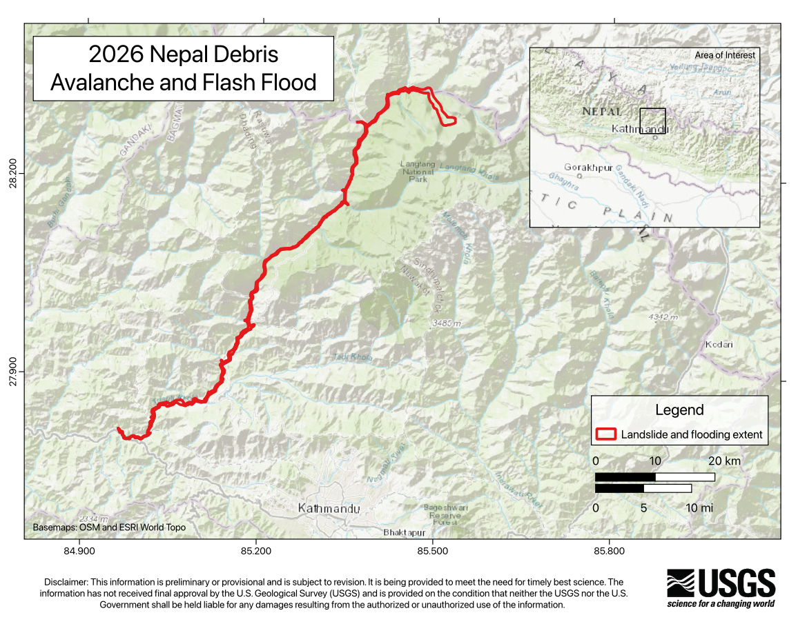
On Wednesday morning (local time), 26 August 2026, a catastrophic debris flow and flood was likely triggered by rapid slope failure involving a glacier in Lāṅṭāṇ National Park, Nepal, near the border with China. This debris flow and flooding travelled nearly 100 km and impacted populated areas downstream along the Lende Kholā and Trishuli̇̄ Kholā rivers, including the Rasuwāgaḍhi̇̄ border post between China and Nepal. Preliminary media reports and imagery analysis indicate many buildings and infrastructure have likely been buried or destroyed, including a vital highway connecting China and Nepal.
Our primary focus is supporting response and recovery efforts through hazard mapping using satellite imagery.
This landslide event page was developed for the 2026 Nepal Debris Avalanche and Flash Flood response (August 27th to August 28th, 2026) to communicate timely preliminary information to the public and partner agencies. Following the conclusion of the immediate response, the page will no longer be updated. Last update: 8/28/2026.
Our thoughts go out to the people affected by the 2026 Nepal Debris Avalanche and the significant flooding that continues to impact the region.
Findings | More Information | Data | Publications
What we are doing
USGS geologists are mapping the inundation boundary of the debris flow and flood by using satellite imagery. By comparing images taken before and after the event, geologists can identify newly affected areas, trace the limits of inundation, and disturbed surfaces from undisturbed terrain.
Findings (as of 8/28/26):
The slope failure involving a glacier generated energy equivalent to a M5.2 earthquake. The debris flow and flood travelled approximately 100 kilometers (approximately 62 miles). A second seismic event was recorded approximately 3-hours later, generating energy equivalent to a M4.2 earthquake.
At this time, it is unclear if the initial slope failure was a landslide incorporating part of a glacier or a glacial collapse. A glacial collapse is where a portion of a glacier breaks off, and the debris rapidly moves downslope. The glacial debris contained water and ice that rapidly melted, picking up more material and water as it flowed downslope in the existing stream and river channels, creating a fast-moving, far-traveled landslide and flood laden with boulders and other rubble.
Regional Background
The geology of the area is composed of high-grade metamorphic rocks (gneisses, quartzites, marbles). This mountain was previously the source of another large debris avalanche in 2015 caused by a M7.8 earthquake. There, several million cubic meters of ice and debris collapsed, starting at 5,000-meter elevation, and fell nearly 1,900 meters, burying a village, and killing more than 200.
Contributors to this page include Stephen Slaughter, Corina Cerovski-Darriau, Jenny Riker, Steven Sobieszczyk, Lauren Schaefer, Elaine Collins, Elizabeth Eiden, and Marísa Macías.
The views and conclusions contained in links external to the U.S. Geological Survey below are those of non-U.S. Geological Survey authors and should not be interpreted as necessarily representing the views or official policies, either expressed or implied, of the U.S. Government.
View the USGS earthquake event page for the primary seismic event.
View the USGS earthquake event page for the secondary seismic event.
View the Center for Land Surface Hazards August 2026 Nepal Trishuli Flood story map.
Learn more about landslides.
Learn more about landslide preparedness.
Learn more about the National Landslide Susceptibility Map.
Learn more about the Landslide Hazards Program.
Learn more about USGS Landslide Response.
| Disclaimer: This information is preliminary or provisional and is subject to revision. It is being provided to meet the need for timely best science. The information has not received final approval by the U.S. Geological Survey (USGS) and is provided on the condition that neither the USGS nor the U.S. Government shall be held liable for any damages resulting from the authorized or unauthorized use of the information. |
Landslide Safety
Landslide Preparedness
On Wednesday morning (local time), 26 August 2026, a catastrophic debris flow and flood was likely triggered by rapid slope failure involving a glacier in Lāṅṭāṇ National Park, Nepal, near the border with China. This debris flow and flooding travelled nearly 100 km and impacted populated areas downstream along the Lende Kholā and Trishuli̇̄ Kholā rivers, including the Rasuwāgaḍhi̇̄ border post between China and Nepal. Preliminary media reports and imagery analysis indicate many buildings and infrastructure have likely been buried or destroyed, including a vital highway connecting China and Nepal.
Our primary focus is supporting response and recovery efforts through hazard mapping using satellite imagery.
This landslide event page was developed for the 2026 Nepal Debris Avalanche and Flash Flood response (August 27th to August 28th, 2026) to communicate timely preliminary information to the public and partner agencies. Following the conclusion of the immediate response, the page will no longer be updated. Last update: 8/28/2026.
Our thoughts go out to the people affected by the 2026 Nepal Debris Avalanche and the significant flooding that continues to impact the region.
Findings | More Information | Data | Publications
What we are doing
USGS geologists are mapping the inundation boundary of the debris flow and flood by using satellite imagery. By comparing images taken before and after the event, geologists can identify newly affected areas, trace the limits of inundation, and disturbed surfaces from undisturbed terrain.
Findings (as of 8/28/26):
The slope failure involving a glacier generated energy equivalent to a M5.2 earthquake. The debris flow and flood travelled approximately 100 kilometers (approximately 62 miles). A second seismic event was recorded approximately 3-hours later, generating energy equivalent to a M4.2 earthquake.
At this time, it is unclear if the initial slope failure was a landslide incorporating part of a glacier or a glacial collapse. A glacial collapse is where a portion of a glacier breaks off, and the debris rapidly moves downslope. The glacial debris contained water and ice that rapidly melted, picking up more material and water as it flowed downslope in the existing stream and river channels, creating a fast-moving, far-traveled landslide and flood laden with boulders and other rubble.
Regional Background
The geology of the area is composed of high-grade metamorphic rocks (gneisses, quartzites, marbles). This mountain was previously the source of another large debris avalanche in 2015 caused by a M7.8 earthquake. There, several million cubic meters of ice and debris collapsed, starting at 5,000-meter elevation, and fell nearly 1,900 meters, burying a village, and killing more than 200.
Contributors to this page include Stephen Slaughter, Corina Cerovski-Darriau, Jenny Riker, Steven Sobieszczyk, Lauren Schaefer, Elaine Collins, Elizabeth Eiden, and Marísa Macías.
The views and conclusions contained in links external to the U.S. Geological Survey below are those of non-U.S. Geological Survey authors and should not be interpreted as necessarily representing the views or official policies, either expressed or implied, of the U.S. Government.
View the USGS earthquake event page for the primary seismic event.
View the USGS earthquake event page for the secondary seismic event.
View the Center for Land Surface Hazards August 2026 Nepal Trishuli Flood story map.
Learn more about landslides.
Learn more about landslide preparedness.
Learn more about the National Landslide Susceptibility Map.
Learn more about the Landslide Hazards Program.
Learn more about USGS Landslide Response.
| Disclaimer: This information is preliminary or provisional and is subject to revision. It is being provided to meet the need for timely best science. The information has not received final approval by the U.S. Geological Survey (USGS) and is provided on the condition that neither the USGS nor the U.S. Government shall be held liable for any damages resulting from the authorized or unauthorized use of the information. |