Landsliding follows signatures of wildfire history and vegetative regrowth in a steep coastal shrubland
Dynamic feedbacks between river meandering and landsliding in northwestern Washington glacial terraces
Constraining landslide frequency across the United States to inform county-level risk reduction
Landslide Hazards Program
The primary objective of the National Landslide Hazards Program is to reduce long-term losses from landslide hazards by improving our understanding of the causes of ground failure and suggesting mitigation strategies.
Landslide Basics
Landslide Basics

What is a landslide? Where do they happen and what causes them? Learn all about the basics of landslides here.
U.S. and Puerto Rico Landslide Hazard Map
U.S. and Puerto Rico Landslide Hazard Map

New high-resolution map of landslide susceptibility for the entire U.S. and Puerto Rico.
Quick Links
Quick Links
Here is where to find some of our most popular content:
News
Hurricane Helene’s Deadly Landslide Legacy
Hurricane Helene’s Deadly Landslide Legacy
USGS Awards a Dozen Landslide Risk Reduction Grants to Enhance Public Safety and Hazard Preparedness Nationwide
USGS Awards a Dozen Landslide Risk Reduction Grants to Enhance Public Safety and Hazard Preparedness Nationwide
USGS Seeks Landslide Risk Reduction Proposals (FY25)
USGS Seeks Landslide Risk Reduction Proposals (FY25)
Publications
Multi-site evaluation of a postfire debris-flow runout forecast method Multi-site evaluation of a postfire debris-flow runout forecast method
Postfire debris flows pose a hazard to human life, property, and infrastructure when they travel from steep source areas to urbanized alluvial fans or other developed areas. Existing methods for rapid (
Landsliding follows signatures of wildfire history and vegetative regrowth in a steep coastal shrubland Landsliding follows signatures of wildfire history and vegetative regrowth in a steep coastal shrubland
Five years after the deadly and destructive 9 January 2018 Montecito debris flows (Santa Barbara County, California, USA), an atmospheric river storm on 9 January 2023 triggered widespread landsliding that affected many of the same drainages in the Santa Ynez Mountains. Using high-resolution aerial imagery, we identified >10,000 landslides over an ∼160 km2 area. Most of the landslides...
Dynamic feedbacks between river meandering and landsliding in northwestern Washington glacial terraces Dynamic feedbacks between river meandering and landsliding in northwestern Washington glacial terraces
Landsliding in river valleys poses unique risks for cascading hazards and can damage infrastructure and cause fatalities. In postglacial valleys, many landslides are posited to occur in relation to lateral river erosion, but the dynamics of fluvial-hillslope interactions are not well understood. Here, we investigate a section of the Nooksack River in western Washington State where the...
Science
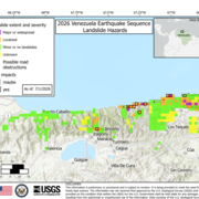
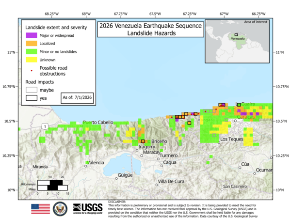
2026 Venezuela Sequence Earthquake-Triggered Landslide Hazards
On Wednesday, June 24th, 2026, a pair of earthquakes of Magnitude 7.2 and Magnitude 7.5 occurred in northern Venezuela, west of Caracas. The U.S. Geological Survey (USGS) Ground Failure product estimated that landslides triggered by this earthquake would likely be significant in number and/or spatial extent. This landslide event page serves to communicate timely science information to our partners...

Postfire Monitoring and Data Collection
The USGS collects data after wildfires and following storm events to better understand debris-flow hazards and their impacts.
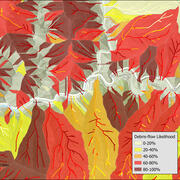
Postfire debris-flow hazard maps
Wildfires can dramatically alter how water moves across the landscape. As a result, even modest rainstorms can trigger dangerous flash floods and debris flows in steep burned areas. In response, the USGS produces postfire debris-flow hazard assessments for recently burned areas. These hazard assessments estimate the likelihood, volume, and combined hazard of debris-flows in recently burned. This...