
Knife Ridge, Elliott State Forest, Oregon Landslide Monitoring Site
Recent Monitoring Data
Rainfall | Ground Water Pressure - Tensiometers | Ground-water and Atmospheric Pressure - Piezometers | Soil Temperature | Soil Water Content | Battery Voltage
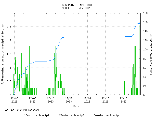
Rainfall
Rainfall is measured at the monitoring site using two 8-inch-diameter tipping-bucket rain gauges that measure 0.01 inch of rainfall per tip. Rainfall data are collected and transmitted every 15 minutes. The graph also shows 15-minute rainfall in millimeters and cumulative rainfall, also in millimeters.
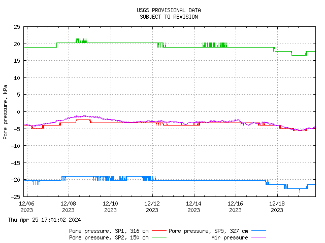
Ground Water Pressure (Tensiometers and Pressure Tranducers)
There are three soil pits located at the site: SP4, SP5, and SP6. Each soil pit area has either a tensiometer or a pressure transducer. The tensiometers can measure pore-water pressures in the range of -85 kPa to 100 kPa, whereas the pressure sensor can measure positve pore-water pressures in the range of 0 to 21 kPa. The location and depth of the instruments are indicated on the graph.
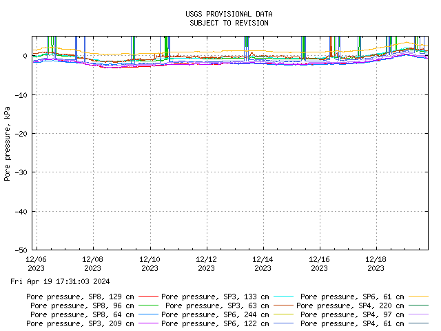
Ground Water Pressure - Tensionmeters
Each instrument array (SP1-SP8) at the monitoring site is equipped with three tensiometers located at various depths. The tensiometers are connected with current transducers that can measure pore-water pressures in the range of +850 hPa to -1000 hPa. The location and depth of the porous tips of each of the tensiometers are indicated on the graphs. Pore-water pressures are reported in hectoPascals (hPa). One hectoPascal is roughly equivalent to the pressure exerted by a 1-cm-deep column of water.
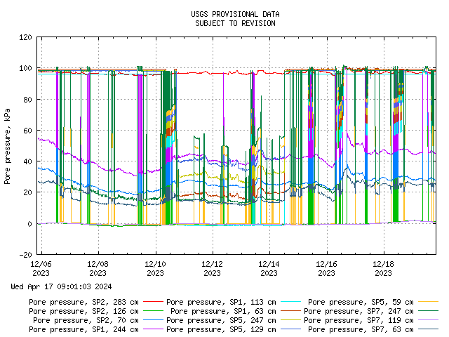
Ground-water and Atmospheric Pressure - Piezometers
The monitoring site is equipped with four piezometers. Three were installed in boreholes at various depths below the ground surface, one at each of the monitoring arrays along the axis of the catchment (SP2, SP1, SP5). The fourth was placed in an enclosure near array SP1 to measure changes in atmospheric pressure. Pore-water pressures are reported in hectoPascals (hPa). One hectoPascal is roughly equivalent to the pressure exerted by a 1-cm-deep column of water.
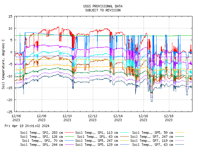
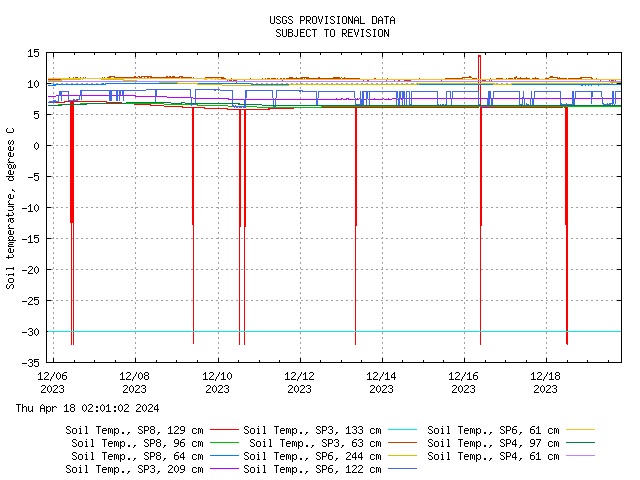
Soil Temperature
Each tensiometer and piezometer has a built-in temperature sensor, either a thermistor or Resistive Temperature Device (RTD). Soil temperature measurements are used to correct measurements by the other instruments and to provide an indication of when the ground is frozen. The location and depth of the instruments are indicated on the graph.
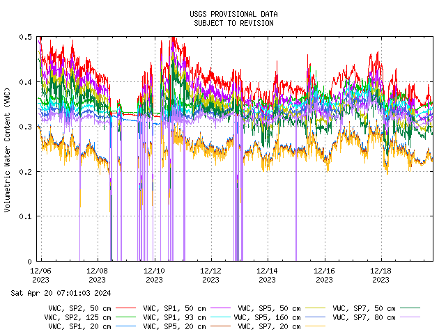
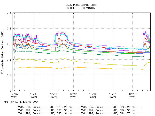
Soil Water Content
Each instrument array (SP1-SP8) at the monitoring site is equipped with three capacitance-based instruments to measure the volumetric water content of the soil. The location and depth of the instruments are indicated on the graphs.
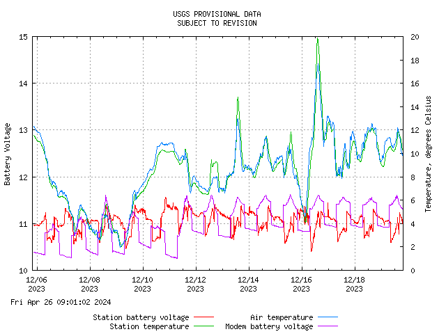
Battery Voltage
Battery voltage is monitored for identifying problems with the power system due to solar panel or battery failures.
Recent Monitoring Data
Rainfall | Ground Water Pressure - Tensiometers | Ground-water and Atmospheric Pressure - Piezometers | Soil Temperature | Soil Water Content | Battery Voltage
Rainfall
Rainfall is measured at the monitoring site using two 8-inch-diameter tipping-bucket rain gauges that measure 0.01 inch of rainfall per tip. Rainfall data are collected and transmitted every 15 minutes. The graph also shows 15-minute rainfall in millimeters and cumulative rainfall, also in millimeters.
Ground Water Pressure (Tensiometers and Pressure Tranducers)
There are three soil pits located at the site: SP4, SP5, and SP6. Each soil pit area has either a tensiometer or a pressure transducer. The tensiometers can measure pore-water pressures in the range of -85 kPa to 100 kPa, whereas the pressure sensor can measure positve pore-water pressures in the range of 0 to 21 kPa. The location and depth of the instruments are indicated on the graph.
Ground Water Pressure - Tensionmeters
Each instrument array (SP1-SP8) at the monitoring site is equipped with three tensiometers located at various depths. The tensiometers are connected with current transducers that can measure pore-water pressures in the range of +850 hPa to -1000 hPa. The location and depth of the porous tips of each of the tensiometers are indicated on the graphs. Pore-water pressures are reported in hectoPascals (hPa). One hectoPascal is roughly equivalent to the pressure exerted by a 1-cm-deep column of water.
Ground-water and Atmospheric Pressure - Piezometers
The monitoring site is equipped with four piezometers. Three were installed in boreholes at various depths below the ground surface, one at each of the monitoring arrays along the axis of the catchment (SP2, SP1, SP5). The fourth was placed in an enclosure near array SP1 to measure changes in atmospheric pressure. Pore-water pressures are reported in hectoPascals (hPa). One hectoPascal is roughly equivalent to the pressure exerted by a 1-cm-deep column of water.
Soil Temperature
Each tensiometer and piezometer has a built-in temperature sensor, either a thermistor or Resistive Temperature Device (RTD). Soil temperature measurements are used to correct measurements by the other instruments and to provide an indication of when the ground is frozen. The location and depth of the instruments are indicated on the graph.
Soil Water Content
Each instrument array (SP1-SP8) at the monitoring site is equipped with three capacitance-based instruments to measure the volumetric water content of the soil. The location and depth of the instruments are indicated on the graphs.
Battery Voltage
Battery voltage is monitored for identifying problems with the power system due to solar panel or battery failures.