
Mariaco, Puerto Rico Landslide Monitoring Station
Completed
By Landslide Hazards Program
February 13, 2023
Mariaco, Puerto Rico Landslide Monitoring Station. The Maricao monitoring site is the westernmost station within the network. The station is situated in a heavily vegetated area underlain by Tertiary-Cretaceous volcanic rock.
Media

Mariaco, Puerto Rico landslide monitoring site. The Maricao monitoring site is the westernmost station within the network. The station is situated in a heavily vegetated area underlain by Tertiary-Cretaceous volcanic rock.
Sources/Usage: Public Domain. View Media Details
Media

Soil suction sensors (right of measuring tape), soil moisture sensors (left of tape), and piezometer (pit base) at the Mariaco, Puerto Rico landslide monitoring site.
Sources/Usage: Public Domain. View Media Details
Media

Corina Cerovski-Darriau and Mason Einbund wire installed sensors to Campbell Scientific datalogger during heavy rainfall event at the Mariaco, Puerto Rico landslide monitoring site.
Sources/Usage: Public Domain. View Media Details
Rainfall | Soil Water Content, Soil Suction, and Ground Water Pressure | Battery Voltage
Rainfall
Media
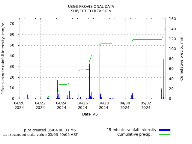
Remote image Url
Sources/Usage: Public Domain. View Media Details
Soil-Water Content, Soil Suction, and Ground Water Pressure
Media
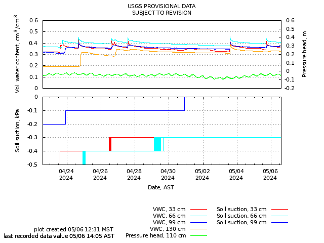
Remote image Url
Sources/Usage: Public Domain. View Media Details
Battery Voltage
Media
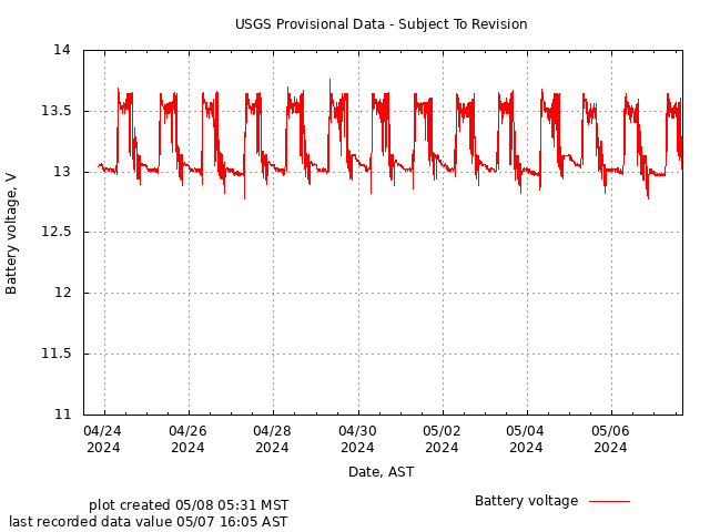
Remote image Url
Sources/Usage: Public Domain. View Media Details
Mariaco, Puerto Rico Landslide Monitoring Station. The Maricao monitoring site is the westernmost station within the network. The station is situated in a heavily vegetated area underlain by Tertiary-Cretaceous volcanic rock.
Media
Mariaco, Puerto Rico landslide monitoring site. The Maricao monitoring site is the westernmost station within the network. The station is situated in a heavily vegetated area underlain by Tertiary-Cretaceous volcanic rock.
Sources/Usage: Public Domain. View Media Details
Media
Soil suction sensors (right of measuring tape), soil moisture sensors (left of tape), and piezometer (pit base) at the Mariaco, Puerto Rico landslide monitoring site.
Sources/Usage: Public Domain. View Media Details
Media
Corina Cerovski-Darriau and Mason Einbund wire installed sensors to Campbell Scientific datalogger during heavy rainfall event at the Mariaco, Puerto Rico landslide monitoring site.
Sources/Usage: Public Domain. View Media Details
Rainfall | Soil Water Content, Soil Suction, and Ground Water Pressure | Battery Voltage
Rainfall
Media
Remote image Url
Sources/Usage: Public Domain. View Media Details
Soil-Water Content, Soil Suction, and Ground Water Pressure
Media
Remote image Url
Sources/Usage: Public Domain. View Media Details
Battery Voltage
Media
Remote image Url
Sources/Usage: Public Domain. View Media Details