
Maunabo, Puerto Rico Landslide Monitoring Station
Active
By Landslide Hazards Program
February 14, 2023
Maunabo, Puerto Rico Landslide Monitoring Station. The Maunabo monitoring site is in the southeast portion of the island. Also densely vegetated, this station is situated in an area of steep slopes underlain by Cretaceous granodiorite-quartz diorite.
Media

Maunabo, Puerto Rico landslide monitoring site. The Maunabo monitoring site is in the southeast portion of the island. Also densely vegetated, this station is situated in an area of steep slopes underlain by Cretaceous granodiorite-quartz diorite.
Sources/Usage: Public Domain. View Media Details
Media

Bill Schulz, Stephen Hughes, Mason Einbund, Kelli Baxstrom, and Tania Figueroa pose next to the completed Maunabo monitoring station at Maunabo, Puerto Rico landslide monitoring site.
Sources/Usage: Public Domain. View Media Details
Media

Bill Schulz checks to make sure installed sensors at the Maunabo monitoring station are successfully collecting values, Maunoba, Puerto Rico landslide monitoring site.
Sources/Usage: Public Domain. View Media Details
Media

View of some of the installed soil moisture sensors (white), soil suction sensors (black), and piezometer (silver) in pit at the Maunoba, Puerto Rico landslide monitoring site.
Sources/Usage: Public Domain. View Media Details
Rainfall | Soil Water Content, Soil Suction, and Ground Water Pressure | Battery Voltage
Rainfall
Media
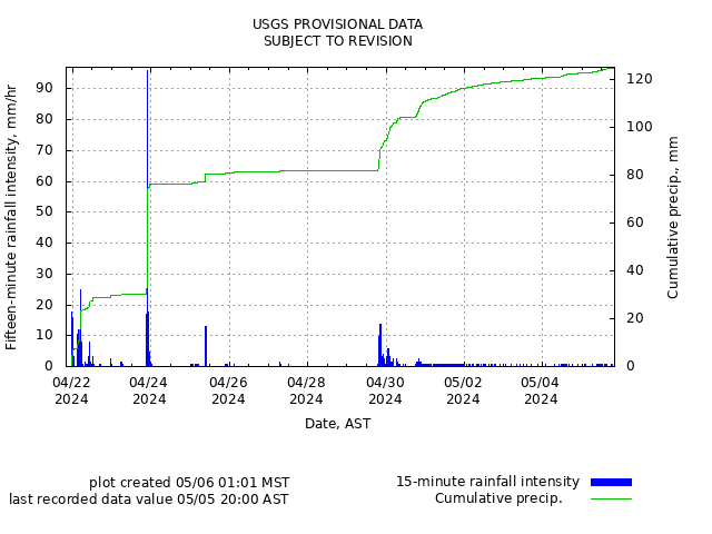
Remote image Url
Sources/Usage: Public Domain. View Media Details
Soil-Water Content, Soil Suction, and Ground Water Pressure
Media
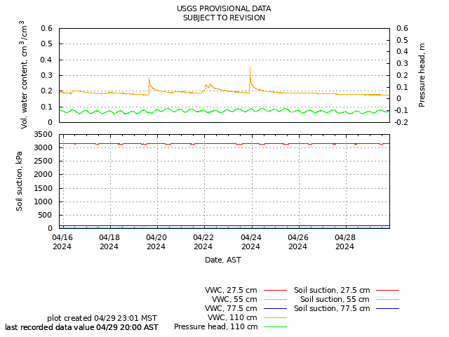
Remote image Url
Sources/Usage: Public Domain. View Media Details
Battery Voltage
Media
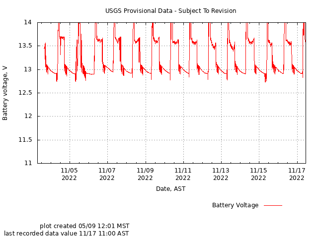
Remote image Url
Sources/Usage: Public Domain. View Media Details
Maunabo, Puerto Rico Landslide Monitoring Station. The Maunabo monitoring site is in the southeast portion of the island. Also densely vegetated, this station is situated in an area of steep slopes underlain by Cretaceous granodiorite-quartz diorite.
Media
Maunabo, Puerto Rico landslide monitoring site. The Maunabo monitoring site is in the southeast portion of the island. Also densely vegetated, this station is situated in an area of steep slopes underlain by Cretaceous granodiorite-quartz diorite.
Sources/Usage: Public Domain. View Media Details
Media
Bill Schulz, Stephen Hughes, Mason Einbund, Kelli Baxstrom, and Tania Figueroa pose next to the completed Maunabo monitoring station at Maunabo, Puerto Rico landslide monitoring site.
Sources/Usage: Public Domain. View Media Details
Media
Bill Schulz checks to make sure installed sensors at the Maunabo monitoring station are successfully collecting values, Maunoba, Puerto Rico landslide monitoring site.
Sources/Usage: Public Domain. View Media Details
Media
View of some of the installed soil moisture sensors (white), soil suction sensors (black), and piezometer (silver) in pit at the Maunoba, Puerto Rico landslide monitoring site.
Sources/Usage: Public Domain. View Media Details
Rainfall | Soil Water Content, Soil Suction, and Ground Water Pressure | Battery Voltage
Rainfall
Media
Remote image Url
Sources/Usage: Public Domain. View Media Details
Soil-Water Content, Soil Suction, and Ground Water Pressure
Media
Remote image Url
Sources/Usage: Public Domain. View Media Details
Battery Voltage
Media
Remote image Url
Sources/Usage: Public Domain. View Media Details