
These projects highlight the important research conducted through the GLGMC.
Title
Description
Since its inception in 1998, the GLGMC has conducted over 100 projects crucial to understanding the glaciated terrain of the Great Lakes region. Locations of the most recent work conducted with NCGMP GLGMC are shown on the map at left. These projects range from broadly used state-wide maps to 7.5' quadrangles with a more local focus.
Click the numbered circles on the map to learn more about these exciting GLGMC projects! You can also view photos and geologic map products related to some of these projects below.
Great Lakes Geologic Mapping Coalition (GLGMC)
The Great Lakes Geologic Mapping Coalition (GLGMC) advances the understanding of the three-dimensional distribution of the glacial sediments that overlie the bedrock of the glaciated terrain of the Great Lakes Region. This region includes 8 U.S. States (Illinois, Indiana, Michigan, Minnesota, New York, Ohio, Pennsylvania, and Wisconsin) and the Canadian Province of Ontario.
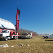
GLGMC Science in Action
The testimonials below demonstrate the impact of recent geologic mapping projects carried out by the GLGMC.

Quaternary Geologic Mapping of the Glaciated Regions Project
Quaternary Geologic Mapping of the Glaciated Regions Project

FEDMAP
FEDMAP develops new ways to understand basic earth science processes and produces high-quality, multipurpose digital geologic maps, regional analyses, and multidimensional geologic models.

STATEMAP
Through the STATEMAP component of the NCGMP, state partners are developing a national geologic framework driven by areas of economic, social, or scientific interest. STATEMAP mapping priorities are established by State Geological Surveys in consultation with a multi-representational State Mapping Advisory Committee. These priorities are based on multiple factors including a) state requirements for...

EDMAP
As the educational component of the National Cooperative Geologic Mapping Program (NCGMP), EDMAP partners with colleges and universities to train the next generation of geologic mappers. To receive information related to the EDMAP Program, click on the button below:
Great Lakes Geologic Mapping Coalition (GLGMC)
The Great Lakes Geologic Mapping Coalition (GLGMC) advances the understanding of the three-dimensional distribution of the glacial sediments that overlie the bedrock of the glaciated terrain of the Great Lakes Region. This region includes 8 U.S. States (Illinois, Indiana, Michigan, Minnesota, New York, Ohio, Pennsylvania, and Wisconsin) and the Canadian Province of Ontario.
GLGMC Science in Action
The testimonials below demonstrate the impact of recent geologic mapping projects carried out by the GLGMC.
Quaternary Geologic Mapping of the Glaciated Regions Project
Quaternary Geologic Mapping of the Glaciated Regions Project
FEDMAP
FEDMAP develops new ways to understand basic earth science processes and produces high-quality, multipurpose digital geologic maps, regional analyses, and multidimensional geologic models.
STATEMAP
Through the STATEMAP component of the NCGMP, state partners are developing a national geologic framework driven by areas of economic, social, or scientific interest. STATEMAP mapping priorities are established by State Geological Surveys in consultation with a multi-representational State Mapping Advisory Committee. These priorities are based on multiple factors including a) state requirements for...
EDMAP
As the educational component of the National Cooperative Geologic Mapping Program (NCGMP), EDMAP partners with colleges and universities to train the next generation of geologic mappers. To receive information related to the EDMAP Program, click on the button below: