
Great Lakes Geologic Mapping Coalition (GLGMC)
Work done by GLGMC member states has been used to make wise decisions at all levels.
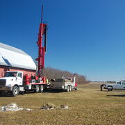
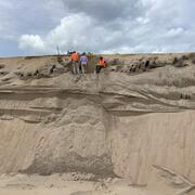
GLGMC projects range from core drilling to creating detailed 3D subsurface maps of glacial sediments in the region.
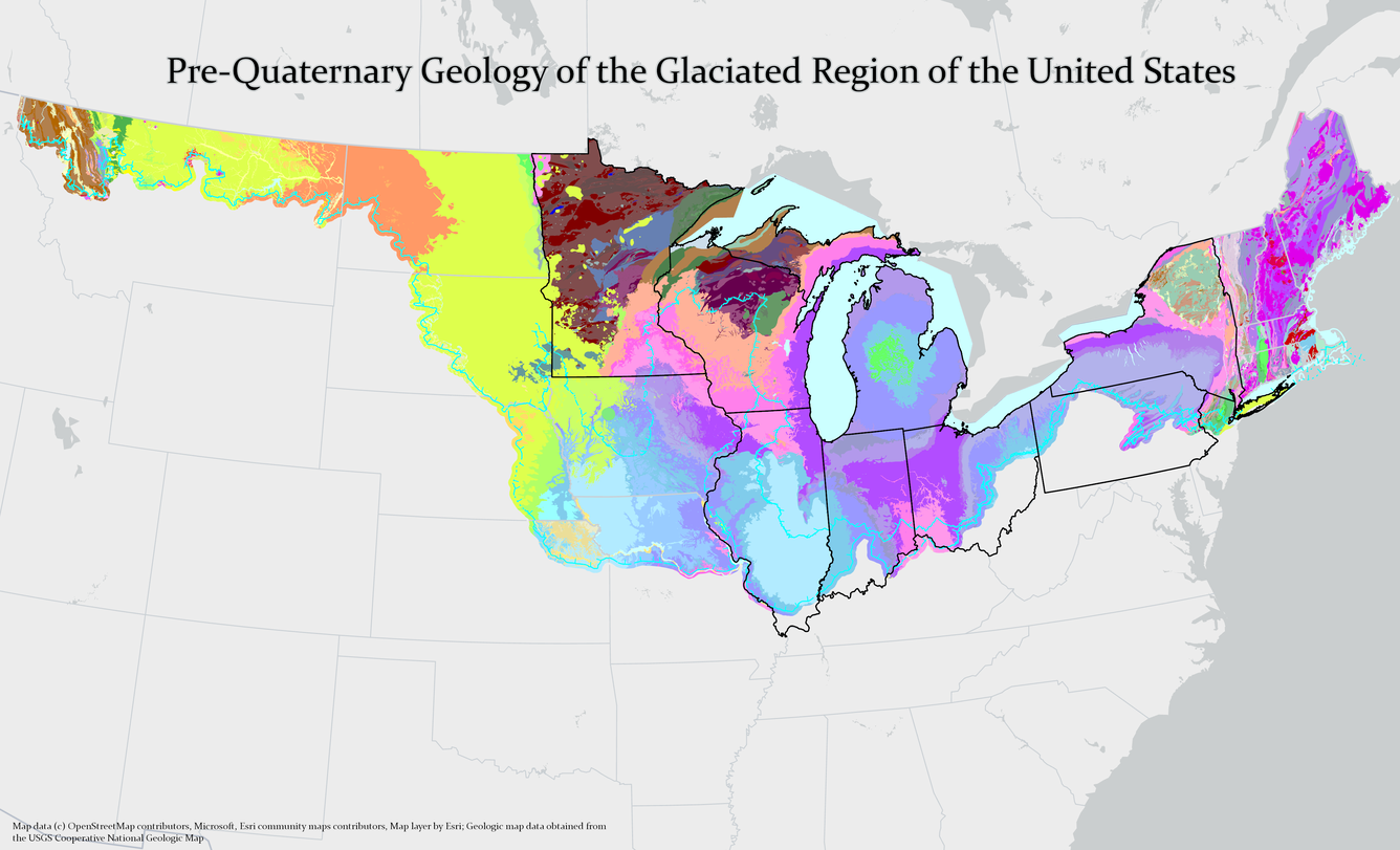
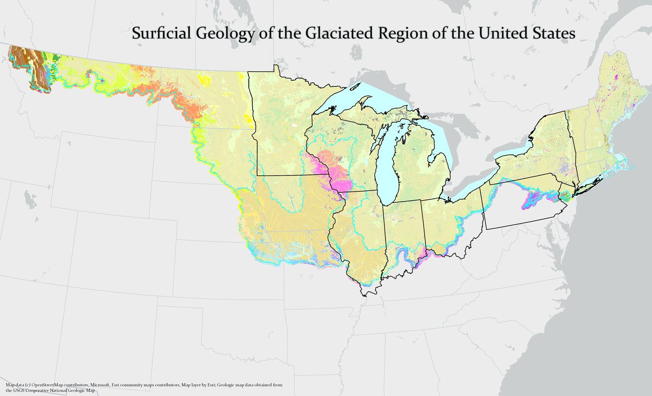
The Great Lakes Geologic Mapping Coalition (GLGMC) advances the understanding of the three-dimensional distribution of the glacial sediments that overlie the bedrock of the glaciated terrain of the Great Lakes Region. This region includes 8 U.S. States (Illinois, Indiana, Michigan, Minnesota, New York, Ohio, Pennsylvania, and Wisconsin) and the Canadian Province of Ontario.
Over the last million years, the Great Lakes region has experienced repeated glacial advances and retreats, leaving behind extensive sediments, abundant natural resources, and widespread effects on the underlying bedrock geology. The unique geological characteristics of the region lead to the realization that surficial geologic mapping needed to be supplemented by mapping of the subsurface. Subsurface and bedrock maps would provide critical information about sand, gravel, minerals, and groundwater unique to the glacial deposits in the region.
In response to the need for detailed sub-surface geologic mapping of the region, the states surrounding the Great Lakes worked together to form the Great Lakes Geologic Mapping Coalition, or "the Coalition." It was formed on December 17, 1998, as a collaboration between the Illinois State Geological Survey, Indiana Geological Survey, Michigan Geological Survey, Ohio Division of Geological Survey, and the USGS. Further expanding in January of 2009, the Coalition added the Minnesota Geological Survey, New York State Geological Survey, Pennsylvania Geologic Survey, and the Wisconsin Geological and Natural History Survey. At this time it was also officially placed within the National Cooperative Geologic Mapping Program. In 2012 the Ontario Geological Survey was included as a non-funded member.
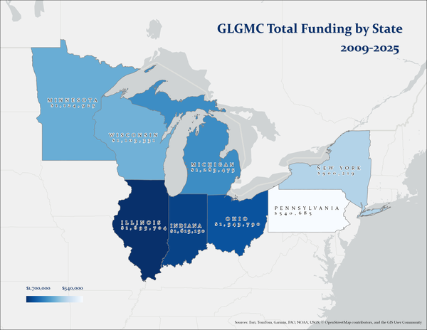
Since its inception, the Coalition has received funding for over 100 geologic mapping projects in the Great Lakes region which has aided in the expansion of knowledge regarding crucial economic and water resources in the area. Since the Coalition's placement within the NCGMP in 2009, NCGMP has funded over \$9.8M US dollars in geologic mapping projects in the region. The map at the right shows the total distribution of those funds per state between 2009 and 2025.
The eight Coalition member states are linked by commonalities of:
- glaciation history
- sand and gravel resources
- Great Lakes ecology
- industrial agriculture
- legacy automotive, coal, steel, and manufacturing industries
GLGMC scientists work collaboratively to advance the understanding of the three-dimensional (3-D) distribution of the glacial sediments overlying the bedrock of the region. Using established field methods and modern techniques, scientists are able to interpret the subsurface geology of the region and in turn produce detailed geologic maps, models and diagrams. As one Coalition geologist stated
"Geologic maps are like journal articles in graphic form."
-Richard Berg, Illinois State Geological Survey
making the essential information they contain accessible to a wide range of audiences from scientists to decision makers and industry partners, to the general public. Insights from geologic maps and subsurface models enable informed decisions on the exploration, use, and protection of vital resources, such as critical minerals, industrial materials, and aquifers, thereby supporting economic prosperity and the well-being of the citizens of the region
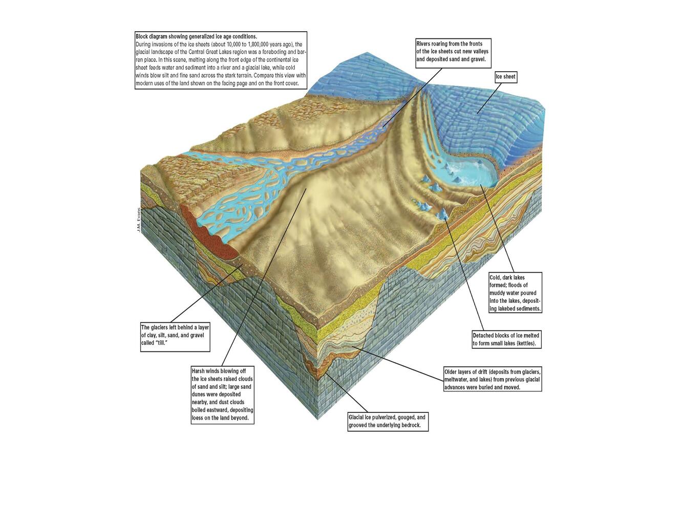
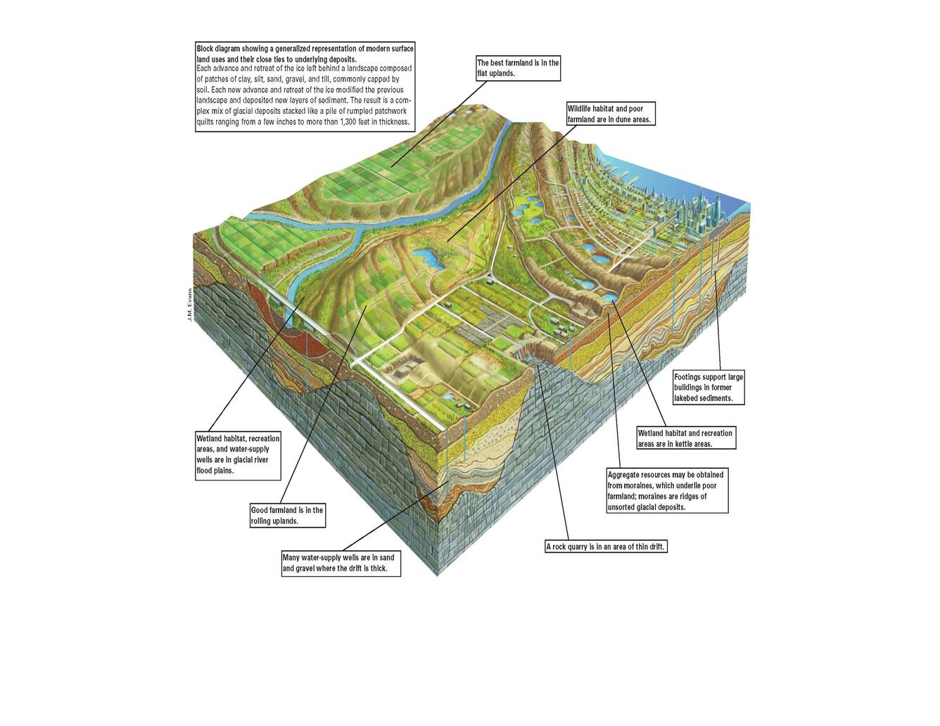
The block diagrams below compare artistic illustrations of what the Earth's surface would have looked like during the last ice age with present day land usage. Scroll between the two to explore how we benefit today from sediments left behind when the glaciers retreated.
Click the images below to learn more about the critical science projects being conducted by our GLGMC partners.
Current Projects
GLGMC Science in Action
Below are other science projects associated with this project.

Quaternary Geologic Mapping of the Glaciated Regions Project
GLGMC Science in Action
GLGMC Current Projects

FEDMAP

STATEMAP

EDMAP
The National Geologic Map Database (NGMDB)
The Great Lakes Geologic Mapping Coalition (GLGMC) advances the understanding of the three-dimensional distribution of the glacial sediments that overlie the bedrock of the glaciated terrain of the Great Lakes Region. This region includes 8 U.S. States (Illinois, Indiana, Michigan, Minnesota, New York, Ohio, Pennsylvania, and Wisconsin) and the Canadian Province of Ontario.
Over the last million years, the Great Lakes region has experienced repeated glacial advances and retreats, leaving behind extensive sediments, abundant natural resources, and widespread effects on the underlying bedrock geology. The unique geological characteristics of the region lead to the realization that surficial geologic mapping needed to be supplemented by mapping of the subsurface. Subsurface and bedrock maps would provide critical information about sand, gravel, minerals, and groundwater unique to the glacial deposits in the region.
In response to the need for detailed sub-surface geologic mapping of the region, the states surrounding the Great Lakes worked together to form the Great Lakes Geologic Mapping Coalition, or "the Coalition." It was formed on December 17, 1998, as a collaboration between the Illinois State Geological Survey, Indiana Geological Survey, Michigan Geological Survey, Ohio Division of Geological Survey, and the USGS. Further expanding in January of 2009, the Coalition added the Minnesota Geological Survey, New York State Geological Survey, Pennsylvania Geologic Survey, and the Wisconsin Geological and Natural History Survey. At this time it was also officially placed within the National Cooperative Geologic Mapping Program. In 2012 the Ontario Geological Survey was included as a non-funded member.
Since its inception, the Coalition has received funding for over 100 geologic mapping projects in the Great Lakes region which has aided in the expansion of knowledge regarding crucial economic and water resources in the area. Since the Coalition's placement within the NCGMP in 2009, NCGMP has funded over \$9.8M US dollars in geologic mapping projects in the region. The map at the right shows the total distribution of those funds per state between 2009 and 2025.
The eight Coalition member states are linked by commonalities of:
- glaciation history
- sand and gravel resources
- Great Lakes ecology
- industrial agriculture
- legacy automotive, coal, steel, and manufacturing industries
GLGMC scientists work collaboratively to advance the understanding of the three-dimensional (3-D) distribution of the glacial sediments overlying the bedrock of the region. Using established field methods and modern techniques, scientists are able to interpret the subsurface geology of the region and in turn produce detailed geologic maps, models and diagrams. As one Coalition geologist stated
"Geologic maps are like journal articles in graphic form."
-Richard Berg, Illinois State Geological Survey
making the essential information they contain accessible to a wide range of audiences from scientists to decision makers and industry partners, to the general public. Insights from geologic maps and subsurface models enable informed decisions on the exploration, use, and protection of vital resources, such as critical minerals, industrial materials, and aquifers, thereby supporting economic prosperity and the well-being of the citizens of the region
The block diagrams below compare artistic illustrations of what the Earth's surface would have looked like during the last ice age with present day land usage. Scroll between the two to explore how we benefit today from sediments left behind when the glaciers retreated.
Click the images below to learn more about the critical science projects being conducted by our GLGMC partners.
Current Projects
GLGMC Science in Action
Below are other science projects associated with this project.
Quaternary Geologic Mapping of the Glaciated Regions Project
GLGMC Science in Action
GLGMC Current Projects
FEDMAP
STATEMAP